FAA INFORMATION EFFECTIVE 30 OCTOBER 2025
Location
| FAA Identifier: | 58M |
| Lat/Long: | 39-34-27.0000N 075-52-11.2000W
39-34.450000N 075-52.186667W
39.5741667,-75.8697778
(estimated) |
| Elevation: | 106.4 ft. / 32.4 m (surveyed) |
| Variation: | 12W (2000) |
| From city: | 3 miles SW of ELKTON, MD |
| Time zone: | UTC -5 (UTC -4 during Daylight Saving Time) |
| Zip code: | 21921 |
Airport Operations
| Airport use: | Open to the public |
| Activation date: | 05/1977 |
| Control tower: | no |
| ARTCC: | NEW YORK CENTER |
| FSS: | LEESBURG FLIGHT SERVICE STATION |
| NOTAMs facility: | DCA (NOTAM-D service available) |
| Attendance: | 0900-1600 |
| Wind indicator: | lighted |
| Segmented circle: | no |
| Lights: | ACTVT REIL RWY 13 & 31; PAPI RWY 13 & 31; MIRL RWY 13/31 - 123.0. |
| Beacon: | white-green (lighted land airport)
ACTVT ROTG BCN - 123.0. |
Airport Communications
| CTAF/UNICOM: | 122.8 |
| PHILADELPHIA APPROACH: | 118.35 |
| PHILADELPHIA DEPARTURE: | 118.35 |
| WX AWOS-3 at EVY (7 nm SE): | 132.325 (302-378-2063) |
| WX ASOS at ILG (14 nm NE): | 123.95 (302-217-3317) |
| WX AWOS-3PT at 0W3 (15 nm W): | 132.725 (667-340-6003) |
- APCH/DEP SVC PRVDD BY PHILADELPHIA (PHL) APCH CTL ON 118.35/323.1
Nearby radio navigation aids
| VOR radial/distance | | VOR name | | Freq | | Var |
|---|
| DQOr253/13.6 | | DUPONT VORTAC | | 114.00 | | 10W |
| MXEr213/22.6 | | MODENA VORTAC | | 113.20 | | 09W |
| ENOr330/26.3 | | SMYRNA VORTAC | | 111.40 | | 09W |
| OODr272/26.5 | | WOODSTOWN VORTAC | | 112.80 | | 10W |
| LRPr158/38.1 | | LANCASTER VOR/DME | | 117.30 | | 09W |
| NDB name | | Hdg/Dist | | Freq | | Var | | ID |
|---|
| HADIN | | 278/11.8 | | 248 | | 10W | | IL | .. .-.. |
| RAINBOW | | 296/35.3 | | 363 | | 11W | | RNB | .-. -. -... |
Airport Services
| Fuel available: | 100LL
100LL:SELF SERVE. |
| Parking: | tiedowns |
| Airframe service: | MINOR |
| Powerplant service: | MINOR |
Runway Information
Runway 13/31
| Dimensions: | 2989 x 70 ft. / 911 x 21 m |
| Surface: | asphalt/aggregate friction seal coat, in fair condition
UNFILLED CRACKS, ALLIGATOR CRACKING, LATERAL & LONGL CRACKING, VEG GROWTH, OXIDATION. |
| Runway edge lights: | medium intensity |
| Runway edge markings: | FADED. |
| Operational restrictions: | RWY 13/31 NO TGL. |
| RUNWAY 13 | | RUNWAY 31 |
| Latitude: | 39-34.556898N | | 39-34.344713N |
| Longitude: | 075-52.473985W | | 075-51.900218W |
| Elevation: | 106.4 ft. | | 62.2 ft. |
| Traffic pattern: | left | | left |
| Runway heading: | 128 magnetic, 116 true | | 308 magnetic, 296 true |
| Displaced threshold: | 288 ft. | | 601 ft. |
| Markings: | basic, in fair condition | | nonprecision, in fair condition |
| Visual slope indicator: | 2-light PAPI on right (5.00 degrees glide path) | | 2-light PAPI on left (4.00 degrees glide path) |
| Runway end identifier lights: | yes | | yes |
| Touchdown point: | yes, no lights | | yes, no lights |
| Obstructions: | 49 ft. trees, 803 ft. from runway, 28 ft. left of centerline, 12:1 slope to clear
APCH SLOPE 20:1 TO DSPLCD THR AT CNTRLN. | | 102 ft. trees, 476 ft. from runway, 110 ft. right of centerline, 2:1 slope to clear
PLINE, MKD 10 FT, 40 FT FM THR. TREES 35 FT, 145 FT FM THR. |
Airport Ownership and Management from official FAA records
| Ownership: | Privately-owned |
| Owner: | CJ FLIGHT CLA LLC
P.O. BOX 445
ELKTON, MD 21922
Phone (410) 398-0234
CJ FLIGHT CLA LLC DBA CLAREMONT AIRPORT. |
| Manager: | MARY HALL
P.O. BOX 445
ELKTON, MD 21922
Phone (410) 398-0234 |
Additional Remarks
| - | DEER & BIRDS ON & INVOF ARPT. |
| - | REDUCED BRAKING ACTION RWY 13 DOWNHILL 1.5 DEG. |
| - | CALM/LIGHT WIND USE RWY 31. |
| - | FOR CD CTC PHILADELPHIA APCH AT (800) 354-9884. |
Instrument Procedures
NOTE: All procedures below are presented as PDF files. If you need a reader for these files, you should download the free Adobe Reader.NOT FOR NAVIGATION. Please procure official charts for flight.
FAA instrument procedures published for use from 30 October 2025 at 0901Z to 27 November 2025 at 0900Z.
IAPs - Instrument Approach Procedures |
|---|
| RNAV (GPS)-B **CHANGED** | |
download (232KB) |
| NOTE: Special Take-Off Minimums/Departure Procedures apply | |
download (210KB) |
Other nearby airports with instrument procedures:
KEVY - Summit Airport (7 nm SE)
KILG - New Castle Airport (14 nm NE)
KAPG - Phillips Army Airfield (15 nm SW)
0W3 - Harford County Airport (15 nm W)
N57 - New Garden Airport (16 nm N)
|
|

Road maps at:
MapQuest
Bing
Google
| Aerial photo |
|---|
WARNING: Photo may not be current or correct
 Photo taken 14-Oct-2016
looking south.
Photo taken 14-Oct-2016
looking south.
Do you have a better or more recent aerial photo of Claremont Airport that you would like to share? If so, please send us your photo.
|
| Sectional chart |
|---|
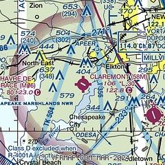
|
| Airport distance calculator |
|---|
|
|
| Sunrise and sunset |
|---|
|
Times for 26-Nov-2025
| | Local
(UTC-5) | | Zulu
(UTC) |
|---|
| Morning civil twilight | | 06:31 | | 11:31 |
| Sunrise | | 07:01 | | 12:01 |
| Sunset | | 16:41 | | 21:41 |
| Evening civil twilight | | 17:10 | | 22:10 |
|
| Current date and time |
|---|
| Zulu (UTC) | 26-Nov-2025 08:40:28 |
|---|
| Local (UTC-5) | 26-Nov-2025 03:40:28 |
|---|
|
| METAR |
|---|
KAPG
11nm SW | 252155Z COR 06004KT 10SM OVC050 11/08 A3002 RMK SLP169 T01060082 $ COR 2156
|
KILG
14nm NE | 260751Z AUTO 20003KT 4SM BR BKN080 BKN110 11/10 A2990 RMK AO2 SLP123 T01110100 $
|
|
| TAF |
|---|
KILG
14nm NE | 260529Z 2606/2706 22005KT 6SM BR OVC006 FM260800 22004KT 5SM BR OVC005 FM261500 23007KT P6SM OVC008 FM261700 23009KT P6SM BKN020 FM261900 24008KT P6SM BKN035 FM270000 28015G25KT P6SM SCT070
|
|
| NOTAMs |
|---|
NOTAMs are issued by the DoD/FAA and will open in a separate window not controlled by AirNav.
|
|

