FAA INFORMATION EFFECTIVE 18 APRIL 2024
Location
| FAA Identifier: | 6K3 |
| Lat/Long: | 42-28-16.6000N 097-53-05.1000W
42-28.276667N 097-53.085000W
42.4712778,-97.8847500
(estimated) |
| Elevation: | 1653 ft. / 503.8 m (surveyed) |
| Variation: | 05E (2010) |
| From city: | 1 mile E of CREIGHTON, NE |
| Time zone: | UTC -5 (UTC -6 during Standard Time) |
| Zip code: | 68729 |
Airport Operations
| Airport use: | Open to the public |
| Activation date: | 05/1947 |
| Control tower: | no |
| ARTCC: | MINNEAPOLIS CENTER |
| FSS: | COLUMBUS FLIGHT SERVICE STATION |
| NOTAMs facility: | OLU (NOTAM-D service available) |
| Attendance: | UNATNDD |
| Wind indicator: | lighted |
| Segmented circle: | yes |
| Lights: | DUSK-2300. FOR MIRL RY 13/31 AFT 2300 ACTVT - CTAF. ACTVT PAPI RY 13-31 - CTAF. |
| Beacon: | white-green (lighted land airport)
Operates sunset to sunrise. |
Airport Communications
- APCH/DEP SVC PRVDD BY MINNEAPOLIS ARTCC ON FREQS 128.0/257.95 (O'NEILL RCAG).
Nearby radio navigation aids
| VOR radial/distance | | VOR name | | Freq | | Var |
|---|
| OFKr317/35.2 | | NORFOLK VOR/DME | | 109.60 | | 08E |
| ONLr080/35.5 | | O'NEILL VORTAC | | 113.90 | | 10E |
| NDB name | | Hdg/Dist | | Freq | | Var | | ID |
|---|
| WAGNER | | 145/39.8 | | 392 | | 08E | | AGZ | .- --. --.. |
Airport Services
| Fuel available: | 100LL
100LL:SELF SVR CC 24 HR |
| Parking: | hangars and tiedowns |
| Airframe service: | NONE |
| Powerplant service: | NONE |
| Bottled oxygen: | NONE |
| Bulk oxygen: | NONE |
Runway Information
Runway 13/31
| Dimensions: | 3700 x 60 ft. / 1128 x 18 m |
| Surface: | concrete, in excellent condition |
| Weight bearing capacity: | |
| Runway edge lights: | medium intensity |
| RUNWAY 13 | | RUNWAY 31 |
| Latitude: | 42-28.500827N | | 42-28.106700N |
| Longitude: | 097-53.408218W | | 097-52.780625W |
| Elevation: | 1641.8 ft. | | 1644.0 ft. |
| Traffic pattern: | left | | left |
| Runway heading: | 125 magnetic, 130 true | | 305 magnetic, 310 true |
| Markings: | nonprecision, in good condition | | nonprecision, in good condition |
| Visual slope indicator: | 2-light PAPI on left (3.00 degrees glide path) | | 2-light PAPI on left (3.00 degrees glide path) |
| Touchdown point: | yes, no lights | | yes, no lights |
Runway 18/36
| Dimensions: | 2100 x 200 ft. / 640 x 61 m |
| Surface: | turf, in fair condition |
| RUNWAY 18 | | RUNWAY 36 |
| Latitude: | 42-28.400582N | | 42-28.060225N |
| Longitude: | 097-53.024990W | | 097-53.107708W |
| Elevation: | 1653.0 ft. | | 1628.0 ft. |
| Traffic pattern: | left | | left |
| Runway heading: | 185 magnetic, 190 true | | 005 magnetic, 010 true |
| Touchdown point: | yes, no lights | | yes, no lights |
| Obstructions: | 33 ft. tree, 249 ft. from runway, 150 ft. left of centerline, 7:1 slope to clear
OBSTN LCTD 150 FT L OF RWY CNTRLN EXTDD. | | 15 ft. road, 320 ft. from runway, 21:1 slope to clear
OBSTN LCTD EITHER SIDE OF RWY CNTRLN EXTDD. |
Airport Ownership and Management from official FAA records
| Ownership: | Publicly-owned |
| Owner: | CREIGHTON AIRPORT AUTHORITY
PO BOX 188
CREIGHTON, NE 68729-0188
Phone (402) 358-3557 |
| Manager: | ROBERT BORGMANN
P.O. BOX 51
CREIGHTON, NE 68729-0051
Phone (402) 360-2916
MANAGER HOME PHONE 402-358-3343. |
Airport Operational Statistics
| Aircraft based on the field: | | 11 | | Single engine airplanes: | | 11 |
| |  | |
| Aircraft operations: avg 44/week * | | 91% | local general aviation | | 9% | transient general aviation | | * for 12-month period ending 28 June 2022 | |
Additional Remarks
| A57-13 | RWY 13 OBST CLNC SLOPE 41:1; TREE 34 ABV; 1,484 OUT; 325R. |
| - | FOR CD CTC MINNEAPOLIS ARTCC AT 651-463-5588. |
| A58-13 | CROPS AT END OF RWY. |
| A58-31 | CROPS AT END OF RWY. |
Instrument Procedures
NOTE: All procedures below are presented as PDF files. If you need a reader for these files, you should download the free Adobe Reader.NOT FOR NAVIGATION. Please procure official charts for flight.
FAA instrument procedures published for use from 18 April 2024 at 0901Z to 16 May 2024 at 0900Z.
IAPs - Instrument Approach Procedures |
|---|
| RNAV (GPS) RWY 13 | |
download (210KB) |
| RNAV (GPS) RWY 31 | |
download (202KB) |
| NOTE: Special Take-Off Minimums/Departure Procedures apply | |
download (192KB) |
Other nearby airports with instrument procedures:
4V9 - Antelope County Airport (23 nm S)
0B4 - Hartington Municipal Airport / Bud Becker Field (29 nm E)
KYKN - Chan Gurney Municipal Airport (35 nm NE)
KOFK - Norfolk Regional Airport/Karl Stefan Memorial Field (35 nm SE)
KONL - The O'Neill Municipal Airport-John L Baker Field (36 nm W)
|
|

Road maps at:
MapQuest
Bing
Google
| Aerial photo |
|---|
WARNING: Photo may not be current or correct
 Photo by Steve Hamilton
Photo taken 01-Oct-2005
Photo by Steve Hamilton
Photo taken 01-Oct-2005
Do you have a better or more recent aerial photo of Creighton Municipal Airport that you would like to share? If so, please send us your photo.
|
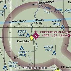
| Sectional chart |
|---|
|
| Airport distance calculator |
|---|
|
|
| Sunrise and sunset |
|---|
|
Times for 19-Apr-2024
| | Local
(UTC-5) | | Zulu
(UTC) |
|---|
| Morning civil twilight | | 06:14 | | 11:14 |
| Sunrise | | 06:43 | | 11:43 |
| Sunset | | 20:18 | | 01:18 |
| Evening civil twilight | | 20:47 | | 01:47 |
|
| Current date and time |
|---|
| Zulu (UTC) | 19-Apr-2024 06:14:48 |
|---|
| Local (UTC-5) | 19-Apr-2024 01:14:48 |
|---|
|
| METAR |
|---|
KONL
35nm W | 190555Z AUTO 28007KT 10SM CLR 01/M05 A3023 RMK AO2 T00141052 10084 20008 400920008
|
KYKN
35nm NE | 190556Z AUTO 29005KT 10SM CLR 02/M03 A3021 RMK AO2 SLP251 T00171028 10083 20017 400940017 56003 FZRANO
|
KOFK
35nm SE | 190556Z AUTO 20006KT 10SM CLR 00/M02 A3022 RMK AO2 SLP243 T00001022 10100 20000 401220000 57002
|
KBVN
45nm S | 190555Z AUTO 00000KT 10SM CLR M01/M03 A3024 RMK AO2 T10101033 10091 21013 401101013
|
|
| TAF |
|---|
KOFK
35nm SE | 190520Z 1906/2006 28005KT P6SM SCT240 FM191700 31016G24KT P6SM BKN200 FM200000 32010KT P6SM SKC
|
|
| NOTAMs |
|---|
NOTAMs are issued by the DoD/FAA and will open in a separate window not controlled by AirNav.
|
|

