FAA INFORMATION EFFECTIVE 09 JULY 2026
Location
| FAA Identifier: | 8D4 |
| Lat/Long: | 43-07-38.7750N 085-40-44.8680W
43-07.646250N 085-40.747800W
43.1274375,-85.6791300
(estimated) |
| Elevation: | 774.7 ft. / 236.1 m (surveyed) |
| Variation: | 04W (1980) |
| From city: | 2 miles SE of SPARTA, MI |
| Time zone: | UTC -4 (UTC -5 during Standard Time) |
| Zip code: | 49345 |
Airport Operations
| Airport use: | Open to the public |
| Activation date: | 12/1944 |
| Control tower: | no |
| ARTCC: | CHICAGO CENTER |
| FSS: | LANSING FLIGHT SERVICE STATION |
| NOTAMs facility: | 8D4 (NOTAM-D service available) |
| Attendance: | MON-FRI 0800-1700 |
| Wind indicator: | lighted |
| Segmented circle: | yes |
| Lights: | ACTVT REIL RWY 07 & 25; PAPI RWY 07 & 25; MIRL RWY 07/25 - CTAF. |
| Beacon: | white-green (lighted land airport)
Operates sunset to sunrise. |
Airport Communications
| CTAF/UNICOM: | 122.8 |
| WX AWOS-3PT: | 126.650 (616-887-6314) |
| GREAT LAKES APPROACH: | 124.6 |
| GREAT LAKES DEPARTURE: | 124.6 |
| WX ASOS at GRR (16 nm SE): | PHONE 616-986-5029 |
- APCH/DEP SVC PRVDD BY CHICAGO ARTCC (ZAU) ON FREQ 128.4 (GRAND RAPIDS RCAG) WHEN GREAT LAKES APCH CTL CLSD.
Nearby radio navigation aids
| VOR radial/distance | | VOR name | | Freq | | Var |
|---|
| VIOr343/22.0 | | VICTORY VOR/DME | | 115.95 | | 04W |
Airport Services
| Fuel available: | 100LL JET-A+ MOGAS
100LL:100LL & JET A+ AVBL H24 SELF SVC VIA CREDIT CARD. |
| Parking: | hangars and tiedowns |
| Airframe service: | MINOR
RPRS AVBL ON CALL 616-706-4421. |
| Powerplant service: | MINOR |
| Bottled oxygen: | NONE |
| Bulk oxygen: | NONE |
Runway Information
Runway 7/25
| Dimensions: | 4033 x 75 ft. / 1229 x 23 m |
| Surface: | asphalt, in good condition |
| Weight bearing capacity: | |
| Runway edge lights: | medium intensity |
| RUNWAY 7 | | RUNWAY 25 |
| Latitude: | 43-07.492777N | | 43-07.799700N |
| Longitude: | 085-41.149545W | | 085-40.346005W |
| Elevation: | 774.4 ft. | | 744.7 ft. |
| Traffic pattern: | left | | left |
| Runway heading: | 066 magnetic, 062 true | | 246 magnetic, 242 true |
| Markings: | nonprecision, in good condition | | nonprecision, in good condition |
| Visual slope indicator: | 4-light PAPI on left (3.50 degrees glide path) | | 4-light PAPI on right (3.50 degrees glide path) |
| Runway end identifier lights: | yes | | yes |
| Touchdown point: | yes, no lights | | yes, no lights |
| Obstructions: | 27 ft. tree, 471 ft. from runway, 166 ft. left of centerline, 10:1 slope to clear | | 34 ft. tree, 716 ft. from runway, 342 ft. right of centerline, 15:1 slope to clear |
Airport Ownership and Management from official FAA records
| Ownership: | Publicly-owned |
| Owner: | CITY OF SPARTA
156 E DIVISION ST
SPARTA, MI 49345-1330
Phone 616-887-8251 |
| Manager: | MICHAEL KRZCIOK
9100 VINTON AVE NW
SPARTA, MI 49345-9423
Phone 616-240-4295
CELL 616-240-4295. |
Additional Remarks
| - | DEER & LRG BIRDS ON & INVOF ARPT. |
| - | ADMIN BLDG ACES: 5-3-2-1. |
| - | FOR CD CTC GREAT LAKES APCH AT 269-459-3344, WHEN APCH CLSD CTC CHICAGO ARTCC AT 630-906-8921. |
Instrument Procedures
NOTE: All procedures below are presented as PDF files. If you need a reader for these files, you should download the free Adobe Reader.NOT FOR NAVIGATION. Please procure official charts for flight.
FAA instrument procedures published for use from 09 July 2026 at 0901Z to 06 August 2026 at 0900Z.
IAPs - Instrument Approach Procedures |
|---|
| RNAV (GPS) RWY 07 **CHANGED** | |
download (194KB) |
| RNAV (GPS) RWY 25 **CHANGED** | |
download (212KB) |
| NOTE: Special Alternate Minimums apply | |
download (57KB) |
| NOTE: Special Take-Off Minimums/Departure Procedures apply | |
download (376KB) |
Other nearby airports with instrument procedures:
KGRR - Gerald R Ford International Airport (16 nm SE)
6D6 - Greenville Municipal Airport (19 nm E)
Z98 - Ottawa Executive Airport (22 nm SW)
KFFX - Fremont Municipal Airport (23 nm NW)
3GM - Grand Haven Memorial Airpark (23 nm W)
|
|

Road maps at:
MapQuest
Bing
Google
| Aerial photo |
|---|
WARNING: Photo may not be current or correct
 Photo by Tal Reichert
Photo taken 29-Jul-2012
looking northeast.
Photo by Tal Reichert
Photo taken 29-Jul-2012
looking northeast.
Do you have a better or more recent aerial photo of Paul C Miller/Sparta Airport that you would like to share? If so, please send us your photo.
|
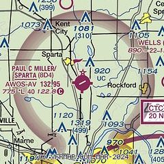
| Sectional chart |
|---|
|
| Airport distance calculator |
|---|
|
|
| Sunrise and sunset |
|---|
|
Times for 15-Jul-2026
| | Local
(UTC-4) | | Zulu
(UTC) |
|---|
| Morning civil twilight | | 05:44 | | 09:44 |
| Sunrise | | 06:18 | | 10:18 |
| Sunset | | 21:20 | | 01:20 |
| Evening civil twilight | | 21:54 | | 01:54 |
|
| Current date and time |
|---|
| Zulu (UTC) | 15-Jul-2026 22:42:11 |
|---|
| Local (UTC-4) | 15-Jul-2026 18:42:11 |
|---|
|
| METAR |
|---|
KGRR
16nm SE | 152153Z 27011KT 10SM FEW050 BKN250 33/22 A3001 RMK AO2 SLP155 T03330217
|
KFFX
23nm NW | 152215Z AUTO 32009KT 8SM CLR 31/22 A3002 RMK AO2
|
KMKG
24nm W | 152155Z 29010KT 10SM BKN250 29/22 A3003 RMK AO2 SLP164 T02890222
|
KBIV
29nm SW | 152153Z AUTO 30007KT 10SM CLR 29/22 A3004 RMK AO2 SLP166 T02890217
|
KY70
29nm SE | 152215Z AUTO 28012G18KT 10SM FEW046 SCT049 BKN060 34/23 A2999 RMK AO2
|
|
| TAF |
|---|
KGRR
16nm SE | 151732Z 1518/1618 28007KT P6SM SCT250 FM152300 28010KT 5SM FU SCT250 FM160400 04004KT 3SM FU SCT250
|
|
| NOTAMs |
|---|
NOTAMs are issued by the DoD/FAA and will open in a separate window not controlled by AirNav.
|
|

