FAA INFORMATION EFFECTIVE 22 JANUARY 2026
Location
| FAA Identifier: | 6D6 |
| Lat/Long: | 43-08-31.7000N 085-15-13.9000W
43-08.528333N 085-15.231667W
43.1421389,-85.2538611
(estimated) |
| Elevation: | 854.6 ft. / 260.5 m (surveyed) |
| Variation: | 05W (2000) |
| From city: | 3 miles S of GREENVILLE, MI |
| Time zone: | UTC -5 (UTC -4 during Daylight Saving Time) |
| Zip code: | 48838 |
Airport Operations
| Airport use: | Open to the public |
| Activation date: | 03/1941 |
| Control tower: | no |
| ARTCC: | CHICAGO CENTER |
| FSS: | LANSING FLIGHT SERVICE STATION |
| NOTAMs facility: | LAN (NOTAM-D service available) |
| Attendance: | MON-FRI 0800-1700, ALL SAT 0800-1200, ALL SUN ON CALL
UNATNDD MAJOR HOLS. FOR SVC SUNDAYS CALL AMGR. |
| Wind indicator: | lighted |
| Segmented circle: | no |
| Lights: | ACTVT REIL RWY 28; PAPI RWY 10 & 28; MIRL RWY 10/28 - CTAF. |
| Beacon: | white-green (lighted land airport)
Operates sunset to sunrise. |
Airport Communications
| CTAF/UNICOM: | 122.8 |
| GREAT LAKES APPROACH: | 124.6 |
| GREAT LAKES DEPARTURE: | 124.6 |
| WX AWOS-3 at Y70 (15 nm SE): | 118.9 (616-523-1852) |
| WX AWOS-3PT at 8D4 (19 nm W): | 126.650 (616-887-6314) |
| WX ASOS at GRR (20 nm SW): | PHONE 616-986-5029 |
- APCH/DEP SVC PRVDD BY CHICAGO ARTCC (ZAU) ON FREQ 128.4 (GRAND RAPIDS RCAG) WHEN GREAT LAKES APCH CTL CLSD.
Nearby radio navigation aids
| VOR radial/distance | | VOR name | | Freq | | Var |
|---|
| VIOr031/23.8 | | VICTORY VOR/DME | | 115.95 | | 04W |
| MOPr223/36.6 | | MOUNT PLEASANT VOR/DME | | 110.60 | | 05W |
Airport Services
| Fuel available: | 100LL JET-A+
100LL:100LL & JET A+ AVBL SELF SVC ONLY. |
| Parking: | hangars and tiedowns |
| Airframe service: | MAJOR |
| Powerplant service: | MAJOR |
| Bottled oxygen: | NONE |
| Bulk oxygen: | NONE |
Runway Information
Runway 10/28
| Dimensions: | 4199 x 75 ft. / 1280 x 23 m |
| Surface: | asphalt, in good condition |
| Weight bearing capacity: | |
| Runway edge lights: | medium intensity |
| RUNWAY 10 | | RUNWAY 28 |
| Latitude: | 43-08.555330N | | 43-08.500672N |
| Longitude: | 085-15.682677W | | 085-14.741530W |
| Elevation: | 854.6 ft. | | 835.9 ft. |
| Traffic pattern: | left | | left |
| Runway heading: | 100 magnetic, 095 true | | 280 magnetic, 275 true |
| Markings: | nonprecision, in good condition | | nonprecision, in good condition |
| Visual slope indicator: | 4-light PAPI on left (3.50 degrees glide path) | | 4-light PAPI on left (3.00 degrees glide path) |
| Runway end identifier lights: | no | | yes |
| Touchdown point: | yes, no lights | | yes, no lights |
| Obstructions: | 17 ft. trees, 227 ft. from runway, 258 ft. right of centerline, 1:1 slope to clear | | 38 ft. trees, 656 ft. from runway, 176 ft. right of centerline, 12:1 slope to clear |
Runway 18/36
| Dimensions: | 1730 x 200 ft. / 527 x 61 m |
| Surface: | turf, in poor condition
RWY SFC ROUGH & UNEVEN; MAY BE SOFT IN SPRING. |
| Runway edge markings: | RWY & DTHR MKD WITH 3 FT YELLOW CONES. |
| RUNWAY 18 | | RUNWAY 36 |
| Latitude: | 43-08.669763N | | 43-08.385875N |
| Longitude: | 085-15.264425W | | 085-15.295163W |
| Elevation: | 851.1 ft. | | 839.9 ft. |
| Traffic pattern: | left | | left |
| Runway heading: | 190 magnetic, 185 true | | 010 magnetic, 005 true |
| Displaced threshold: | no | | 378 ft. |
| Runway end identifier lights: | no | | no |
| Touchdown point: | yes, no lights | | yes, no lights |
| Obstructions: | 52 ft. trees, 125 ft. right of centerline
CTLG OBSTN EXCEEDS A 45 DEG SLP. | | 40 ft. trees, 364 ft. from runway, 173 ft. right of centerline, 9:1 slope to clear |
Airport Ownership and Management from official FAA records
| Ownership: | Publicly-owned |
| Owner: | CITY OF GREENVILLE
411 S LAFAYETTE ST
GREENVILLE, MI 48838-2899
Phone 616-754-5645 |
| Manager: | PETER R JEPPESEN
10593 SW GREENVILLE RD
GREENVILLE, MI 48838-8743
Phone 616-754-5534
CELL 989-287-2629. |
Additional Remarks
| - | RWY 18/36 NO SNOW REMOVAL. |
| - | DEER & BIRDS ON & INVOF ARPT. |
| - | ADMIN BLDG ACES 5-3-2-1-*(STAR). |
| - | FOR CD CTC GREAT LAKES APCH AT 269-459-3344, WHEN APCH CLSD CTC CHICAGO ARTCC AT 630-906-8921. |
Instrument Procedures
NOTE: All procedures below are presented as PDF files. If you need a reader for these files, you should download the free Adobe Reader.NOT FOR NAVIGATION. Please procure official charts for flight.
FAA instrument procedures published for use from 22 January 2026 at 0901Z to 19 February 2026 at 0900z.
IAPs - Instrument Approach Procedures |
|---|
| RNAV (GPS) RWY 10 | |
download (225KB) |
| RNAV (GPS) RWY 28 | |
download (215KB) |
| NOTE: Special Take-Off Minimums/Departure Procedures apply | |
download (255KB) |
Other nearby airports with instrument procedures:
Y70 - Ionia County Airport (15 nm SE)
13C - Lakeview Airport/Griffith Field (19 nm N)
8D4 - Paul C Miller/Sparta Airport (19 nm W)
KGRR - Gerald R Ford International Airport (20 nm SW)
KAMN - Gratiot Community Airport (27 nm NE)
|
|

Road maps at:
MapQuest
Bing
Google
| Aerial photo |
|---|
WARNING: Photo may not be current or correct

Do you have a better or more recent aerial photo of Greenville Municipal Airport that you would like to share? If so, please send us your photo.
|
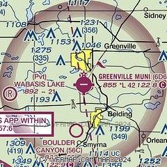
| Sectional chart |
|---|
|
| Airport distance calculator |
|---|
|
|
| Sunrise and sunset |
|---|
|
Times for 24-Jan-2026
| | Local
(UTC-5) | | Zulu
(UTC) |
|---|
| Morning civil twilight | | 07:34 | | 12:34 |
| Sunrise | | 08:05 | | 13:05 |
| Sunset | | 17:41 | | 22:41 |
| Evening civil twilight | | 18:12 | | 23:12 |
|
| Current date and time |
|---|
| Zulu (UTC) | 25-Jan-2026 00:34:08 |
|---|
| Local (UTC-5) | 24-Jan-2026 19:34:08 |
|---|
|
| METAR |
|---|
KY70
15nm SE | 250015Z AUTO 07006KT 10SM SCT080 OVC090 M16/M22 A3055 RMK AO2
|
KGRR
19nm SW | 242353Z 09008KT 10SM OVC095 M16/M22 A3055 RMK AO2 SLP371 4/008 T11561222 11150 21161 56009
|
KAMN
27nm NE | 250015Z AUTO 11003KT 10SM CLR M16/M22 A3056 RMK AO2
|
|
| TAF |
|---|
KGRR
19nm SW | 241720Z 2418/2518 14006KT P6SM BKN035 FM250900 09005KT P6SM BKN060 PROB30 2509/2515 5SM -SN FM251500 05007KT 4SM -SN BKN035
|
|
| NOTAMs |
|---|
NOTAMs are issued by the DoD/FAA and will open in a separate window not controlled by AirNav.
|
|

