FAA INFORMATION EFFECTIVE 09 JULY 2026
Location
| FAA Identifier: | ACT |
| Lat/Long: | 31-36-43.9000N 097-13-49.1000W
31-36.731667N 097-13.818333W
31.6121944,-97.2303056
(estimated) |
| Elevation: | 516.1 ft. / 157.3 m (surveyed) |
| Variation: | 07E (1985) |
| From city: | 5 miles NW of WACO, TX |
| Time zone: | UTC -5 (UTC -6 during Standard Time) |
| Zip code: | 76708 |
Airport Operations
| Airport use: | Open to the public |
| Activation date: | 07/1943 |
| Control tower: | yes |
| ARTCC: | FORT WORTH CENTER |
| FSS: | FORT WORTH FLIGHT SERVICE STATION |
| NOTAMs facility: | ACT (NOTAM-D service available) |
| Attendance: | 0600-2200 |
| Wind indicator: | lighted |
| Segmented circle: | yes |
| Lights: | WHEN ATCT CLSD: MALSR RWY 19; HIRL RWY 01/19 PRESET LOW INTST, TO INCR INTST ACTVT - CTAF. REIL RWY 14; MIRL RWY 14/32; TWY LGTS PRESET LOW INTST WHEN WIND FAVORS, OTRW NOT AVBL. |
| Beacon: | white-green (lighted land airport)
Operates sunset to sunrise. |
| Landing fee: | yes, LDG FEE FOR ACRFT OVR 7500 LBS. |
| Fire and rescue: | ARFF index B |
| Airline operations: | PPR FOR UNSKED ACR OPNS CALL AMGR 254-750-8657. |
Airport Communications
| CTAF: | 119.3 |
| UNICOM: | 122.95 |
| ATIS: | 123.85 |
| WX ASOS: | PHONE 254-218-3267 |
| WACO GROUND: | 121.9 [0600-0000] |
| WACO TOWER: | 119.3 257.8 [0600-0000] |
| WACO APPROACH: | 127.65 227.125 [0600-0000] |
| WACO DEPARTURE: | 126.125 227.125 [0600-0000] |
| ASR: | 132.525 |
| EMERG: | 121.5 243.0 |
| WX AWOS-3PT at CNW (8 nm E): | 134.225 (254-867-3880) |
| WX AWOS-3PT at PWG (9 nm SW): | 135.525 (254-848-4581) |
- APCH/DEP CTL SVC PRVDD BY FORT WORTH ARTCC (ZFW) ON FREQS 133.3/269.5 (WACO RCAG) WHEN WACO APCH CTL (ACT) CLSD.
Nearby radio navigation aids
| VOR radial/distance | | VOR name | | Freq | | Var |
|---|
| ACTr138/3.6 | | WACO VORTAC | | 115.30 | | 09E |
Airport Services
| Fuel available: | 100LL JET-A UL94 |
| Parking: | hangars and tiedowns |
| Airframe service: | MAJOR |
| Powerplant service: | MAJOR |
| Bottled oxygen: | NONE |
| Bulk oxygen: | HIGH |
Runway Information
Runway 1/19
| Dimensions: | 7107 x 150 ft. / 2166 x 46 m |
| Surface: | asphalt/grooved, in good condition |
| Weight bearing capacity: | | Single wheel: | 120.0 | | Double wheel: | 220.0 | | Double tandem: | 374.0 | | Dual double tandem: | 882.0 |
|
| Runway edge lights: | high intensity |
| RUNWAY 1 | | RUNWAY 19 |
| Latitude: | 31-36.212025N | | 31-37.348218N |
| Longitude: | 097-13.797248W | | 097-13.460597W |
| Elevation: | 508.4 ft. | | 502.3 ft. |
| Traffic pattern: | left | | left |
| Runway heading: | 007 magnetic, 014 true | | 187 magnetic, 194 true |
| Displaced threshold: | 102 ft. | | no |
| Declared distances: | TORA:7107 TODA:7107 ASDA:7107 LDA:7005 | | TORA:7107 TODA:7107 ASDA:6605 LDA:6605 |
| Markings: | nonprecision, in good condition | | precision, in good condition |
| Visual slope indicator: | 4-light PAPI on right (3.00 degrees glide path) | | |
| RVR equipment: | rollout | | touchdown |
| Approach lights: | | | MALSR: 1,400 foot medium intensity approach lighting system with runway alignment indicator lights |
| Touchdown point: | yes, no lights | | yes, no lights |
| Instrument approach: | | | ILS/DME |
| Obstructions: | 10 ft. road, 650 ft. from runway, 45:1 slope to clear | | none |
Runway 14/32
| Dimensions: | 5103 x 150 ft. / 1555 x 46 m |
| Surface: | asphalt/grooved, in good condition |
| Weight bearing capacity: | | Single wheel: | 114.0 | | Double wheel: | 190.0 | | Double tandem: | 332.0 | | Dual double tandem: | 773.0 |
|
| Runway edge lights: | medium intensity |
| RUNWAY 14 | | RUNWAY 32 |
| Latitude: | 31-37.025608N | | 31-36.302402N |
| Longitude: | 097-14.334358W | | 097-13.831305W |
| Elevation: | 508.6 ft. | | 511.7 ft. |
| Traffic pattern: | left | | left |
| Runway heading: | 142 magnetic, 149 true | | 322 magnetic, 329 true |
| Declared distances: | TORA:5103 TODA:5103 ASDA:5103 LDA:5103 | | TORA:5103 TODA:5103 ASDA:5103 LDA:5103 |
| Markings: | nonprecision, in fair condition | | nonprecision, in fair condition |
| Visual slope indicator: | 4-light PAPI on left (3.00 degrees glide path) | | 4-light PAPI on left (3.00 degrees glide path) |
| Runway end identifier lights: | yes | | |
| Touchdown point: | yes, no lights | | yes, no lights |
| Obstructions: | none | | 10 ft. road, 550 ft. from runway, 35:1 slope to clear |
Airport Ownership and Management from official FAA records
| Ownership: | Publicly-owned |
| Owner: | CITY OF WACO
PO BOX 2570
WACO, TX 76702-2570
Phone 254-750-5640 |
| Manager: | JAMES C. HARRIS
7909 KARL MAY DRIVE, 2ND FLOOR, ADMINISTRATION OFFICE
WACO, TX 76708
Phone 254-750-8656 |
Additional Remarks
| A39-01/19 | PCR VALUE: 547/F/B/W/T |
| A39-14/32 | PCR VALUE: 462/F/B/W/T |
| - | FOR CD CTC WACO APCH AT 121.9 OR CTC FORT WORTH ARTCC AT 817-858-7584. |
| - | PPR RQRD FOR UNSKED ACR OPNS. CALL ARPT OPS AT 254-750-8656 OR SUBMIT ONLINE AT HTTPS://PORTAL.AEROSIMPLE.COM/FORMS/US/2E387A38-D506-11EB-946D-0A58A9FEAC02 |
Instrument Procedures
NOTE: All procedures below are presented as PDF files. If you need a reader for these files, you should download the free Adobe Reader.NOT FOR NAVIGATION. Please procure official charts for flight.
FAA instrument procedures published for use from 09 July 2026 at 0901Z to 06 August 2026 at 0900Z.
IAPs - Instrument Approach Procedures |
|---|
| ILS OR LOC RWY 19 | |
download (240KB) |
| RNAV (GPS) RWY 01 | |
download (244KB) |
| RNAV (GPS) RWY 14 | |
download (229KB) |
| RNAV (GPS) RWY 19 | |
download (236KB) |
| RNAV (GPS) RWY 32 | |
download (272KB) |
| VOR/DME RWY 32 | |
download (223KB) |
| VOR RWY 14 | |
download (236KB) |
| Radar Approach Procedures available | |
download |
| NOTE: Special Alternate Minimums apply | |
download (18KB) |
| NOTE: Special Take-Off Minimums/Departure Procedures apply | |
download (308KB) |
Other nearby airports with instrument procedures:
KCNW - TSTC Waco Airport (8 nm E)
KPWG - Mc Gregor Executive Airport (9 nm SW)
T15 - Marlin Airport (25 nm SE)
KTPL - Draughon-Miller Central Texas Regional Airport (29 nm S)
KINJ - Hillsboro Municipal Airport (29 nm N)
|
|

Road maps at:
MapQuest
Bing
Google
| Aerial photo |
|---|
WARNING: Photo may not be current or correct
 Photo by Kurtis Samples
Photo taken 01-May-2014
looking west.
Photo by Kurtis Samples
Photo taken 01-May-2014
looking west.
Do you have a better or more recent aerial photo of Waco Regional Airport that you would like to share? If so, please send us your photo.
|
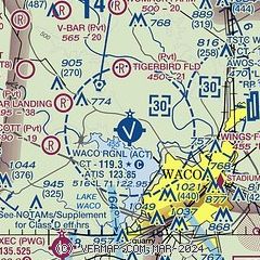
| Sectional chart |
|---|
|
CAUTION: Diagram may not be current
 Download PDF
of official airport diagram from the FAA
| Airport distance calculator |
|---|
|
|
| Sunrise and sunset |
|---|
|
Times for 28-Jul-2026
| | Local
(UTC-5) | | Zulu
(UTC) |
|---|
| Morning civil twilight | | 06:17 | | 11:17 |
| Sunrise | | 06:43 | | 11:43 |
| Sunset | | 20:27 | | 01:27 |
| Evening civil twilight | | 20:54 | | 01:54 |
|
| Current date and time |
|---|
| Zulu (UTC) | 28-Jul-2026 09:34:57 |
|---|
| Local (UTC-5) | 28-Jul-2026 04:34:57 |
|---|
|
| METAR |
|---|
| KACT | 280851Z AUTO 19010KT 10SM CLR 26/22 A2988 RMK AO2 SLP109 T02560217 55001 $
|
KCNW
8nm E | 280255Z 15007KT 10SM CLR
|
KPWG
10nm SW | 280856Z AUTO 18009KT 10SM CLR 26/22 A2990 RMK AO2 SLP116 T02610222 55001
|
|
| TAF |
|---|
| KACT | 280522Z 2806/2906 18011KT P6SM FEW250
|
|
| NOTAMs |
|---|
NOTAMs are issued by the DoD/FAA and will open in a separate window not controlled by AirNav.
|
|


