FAA INFORMATION EFFECTIVE 19 MARCH 2026
Location
| FAA Identifier: | C35 |
| Lat/Long: | 43-31-33.2367N 089-58-59.5980W
43-31.553945N 089-58.993300W
43.5258991,-89.9832217
(estimated) |
| Elevation: | 906.2 ft. / 276.2 m (surveyed) |
| Variation: | 00E (1985) |
| From city: | 1 mile E of REEDSBURG, WI |
| Time zone: | UTC -5 (UTC -6 during Standard Time) |
| Zip code: | 53959 |
Airport Operations
| Airport use: | Open to the public |
| Activation date: | 04/1948 |
| Control tower: | no |
| ARTCC: | CHICAGO CENTER |
| FSS: | GREEN BAY FLIGHT SERVICE STATION |
| NOTAMs facility: | GRB (NOTAM-D service available) |
| Attendance: | 0800-1600 |
| Wind indicator: | lighted |
| Segmented circle: | yes |
| Lights: | MIRL RWY 18/36 & 07/25 PRESET TO LOW SS-SR; TO INCR INTST AND ACTVT REIL RWY 18 & 36; PAPI RWY 18 - CTAF. |
| Beacon: | white-green (lighted land airport)
Operates sunset to sunrise. |
Airport Communications
| CTAF/UNICOM: | 122.8 |
| WX AWOS-3PT: | 118.95 (608-768-0023) |
| MADISON APPROACH: | 135.45 |
| MADISON DEPARTURE: | 135.45 |
| WX AWOS-3 at DLL (9 nm E): | 118.325 (608-356-1071) |
| WX AWOS-3 at 82C (20 nm N): | 123.925 (608-562-6153) |
- APCH/DEP SVC PRVDD BY CHICAGO ARTCC ON FREQS 133.3/257.925 (LONE ROCK RCAG) WHEN MADISON APCH CTL CLSD.
Nearby radio navigation aids
| VOR radial/distance | | VOR name | | Freq | | Var |
|---|
| DLLr258/9.7 | | DELLS VORTAC | | 117.00 | | 03E |
| MSNr306/36.2 | | MADISON VORTAC | | 108.60 | | 03E |
Airport Services
| Fuel available: | 100LL JET-A+
100LL:24 HR FUEL AVBL WITH CREDIT CARD. |
| Parking: | hangars and tiedowns |
| Airframe service: | MAJOR |
| Powerplant service: | MAJOR |
| Bottled oxygen: | NONE |
| Bulk oxygen: | NONE |
Runway Information
Runway 18/36
| Dimensions: | 4840 x 75 ft. / 1475 x 23 m |
| Surface: | asphalt, in fair condition |
| Weight bearing capacity: | |
| Runway edge lights: | medium intensity |
| RUNWAY 18 | | RUNWAY 36 |
| Latitude: | 43-31.906553N | | 43-31.109945N |
| Longitude: | 089-58.931360W | | 089-58.940797W |
| Elevation: | 904.9 ft. | | 881.4 ft. |
| Traffic pattern: | left | | left |
| Runway heading: | 181 | | 001 |
| Displaced threshold: | 440 ft. | | 300 ft. |
| Declared distances: | TORA:4540 TODA:4540 ASDA:4540 LDA:4100 | | TORA:4400 TODA:4400 ASDA:4400 LDA:4100 |
| Markings: | nonprecision, in good condition | | nonprecision, in good condition |
| Visual slope indicator: | 2-light PAPI on left (3.00 degrees glide path) | | |
| Runway end identifier lights: | yes | | yes |
| Touchdown point: | yes, no lights | | yes, no lights |
| Obstructions: | 21 ft. road, 230 ft. from runway, 1:1 slope to clear
10 FT FENCE 190 FT FM RWY END, 120 FT R. | | 17 ft. rr, 200 ft. from runway, 180 ft. left of centerline
17 FT RR 75 FT FM RWY END 250 FT L. |
Runway 7/25
| Dimensions: | 2510 x 50 ft. / 765 x 15 m |
| Surface: | asphalt, in good condition |
| Weight bearing capacity: | |
| Runway edge lights: | medium intensity |
| RUNWAY 7 | | RUNWAY 25 |
| Latitude: | 43-31.567913N | | 43-31.716140N |
| Longitude: | 089-59.368535W | | 089-58.838590W |
| Elevation: | 891.5 ft. | | 906.2 ft. |
| Traffic pattern: | left | | left |
| Runway heading: | 069 | | 249 |
| Displaced threshold: | 229 ft. | | 300 ft. |
| Declared distances: | TORA:2210 TODA:2210 ASDA:2210 LDA:1980 | | TORA:2280 TODA:2280 ASDA:2280 LDA:1980 |
| Markings: | basic, in good condition | | basic, in good condition |
| Runway end identifier lights: | no | | no |
| Touchdown point: | yes, no lights | | yes, no lights |
| Obstructions: | 49 ft. trees, 945 ft. from runway, 225 ft. left of centerline, 15:1 slope to clear
DITCH 10 FT FM RWY END 60 FT L. | | 12 ft. road, 200 ft. from runway
10 FT FENCE 175 FT FM RWY END, 40 FT L. |
Airport Ownership and Management from official FAA records
| Ownership: | Publicly-owned |
| Owner: | CITY OF REEDSBURG
ARPT COMSN 200 VINE STREET
REEDSBURG, WI 53959
Phone 608-524-2396 |
| Manager: | TOM PARKER
1720 E MAIN
REEDSBURG, WI 53959
Phone 608-524-2322
EMAIL ADDRESS: REEDSBURGAVIATION@GMAIL.COM (ALL LOWER CASE) |
Additional Remarks
| - | FOR CD CTC MADISON APP/DEP CON AT 608-249-8240. WHEN MADISON APCH CLSD, FOR CD CTC CHICAGO ARTCC AT 630-906-8921. |
Instrument Procedures
NOTE: All procedures below are presented as PDF files. If you need a reader for these files, you should download the free Adobe Reader.NOT FOR NAVIGATION. Please procure official charts for flight.
FAA instrument procedures published for use from 19 March 2026 at 0901Z to 16 April 2026 at 0900Z.
IAPs - Instrument Approach Procedures |
|---|
| RNAV (GPS) RWY 18 | |
download (221KB) |
| RNAV (GPS) RWY 36 | |
download (201KB) |
| NOTE: Special Alternate Minimums apply | |
download (143KB) |
| NOTE: Special Take-Off Minimums/Departure Procedures apply | |
download (504KB) |
Other nearby airports with instrument procedures:
KDLL - Baraboo/Wisconsin Dells Regional Airport (9 nm E)
91C - Sauk/Prairie Airport (17 nm SE)
82C - Mauston/New Lisbon Union Airport (20 nm N)
93C - Richland Airport (20 nm SW)
KLNR - Tri-County Regional Airport (21 nm SW)
|
|

Road maps at:
MapQuest
Bing
Google
| Aerial photo |
|---|
WARNING: Photo may not be current or correct
 Photo by Timothy Struska
Photo taken 24-Mar-2006
Photo by Timothy Struska
Photo taken 24-Mar-2006
Do you have a better or more recent aerial photo of Reedsburg Municipal Airport that you would like to share? If so, please send us your photo.
|
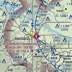
| Sectional chart |
|---|
|
| Airport distance calculator |
|---|
|
|
| Sunrise and sunset |
|---|
|
Times for 26-Mar-2026
| | Local
(UTC-5) | | Zulu
(UTC) |
|---|
| Morning civil twilight | | 06:25 | | 11:25 |
| Sunrise | | 06:53 | | 11:53 |
| Sunset | | 19:18 | | 00:18 |
| Evening civil twilight | | 19:47 | | 00:47 |
|
| Current date and time |
|---|
| Zulu (UTC) | 26-Mar-2026 11:59:55 |
|---|
| Local (UTC-5) | 26-Mar-2026 06:59:55 |
|---|
|
| METAR |
|---|
| KC35 | 261135Z AUTO 33008KT 10SM 11/07 A2977 RMK AO2 T01080066 PWINO
|
KDLL
9nm E | 261155Z AUTO 32005KT 10SM OVC110 13/07 A2976 RMK AO2 T01250067 10125 20060
|
K82C
20nm N | 261135Z AUTO 29005KT 10SM BKN100 11/11 A2977 RMK AO2 T01100107
|
|
| TAF |
|---|
KVOK
26nm NW | 260900Z 2609/2715 22005KT 9999 FEW130 QNH2962INS BECMG 2612/2613 06005KT 9999 FEW100 QNH2972INS BECMG 2617/2618 36010G15KT 9000 -RA OVC060 QNH2981INS BECMG 2620/2621 35010G25KT 9999 NSW BKN060 QNH2986INS BECMG 2704/2705 02012G18KT 9999 FEW040 QNH3021INS TX13/2618Z TNM01/2708Z
|
|
| NOTAMs |
|---|
NOTAMs are issued by the DoD/FAA and will open in a separate window not controlled by AirNav.
|
|

