FAA INFORMATION EFFECTIVE 30 OCTOBER 2025
Location
| FAA Identifier: | F95 |
| Lat/Long: | 30-29-13.3140N 085-06-49.6290W
30-29.221900N 085-06.827150W
30.4870317,-85.1137858
(estimated) |
| Elevation: | 121.2 ft. / 37 m (estimated) |
| Variation: | 02W (1995) |
| From city: | 5 miles NW of BLOUNTSTOWN, FL |
| Time zone: | UTC -6 (UTC -5 during Daylight Saving Time) |
| Zip code: | 32421 |
Airport Operations
| Airport use: | Open to the public |
| Activation date: | 12/1996 |
| Control tower: | no |
| ARTCC: | JACKSONVILLE CENTER |
| FSS: | GAINESVILLE FLIGHT SERVICE STATION |
| NOTAMs facility: | GNV (NOTAM-D service available) |
| Attendance: | MON-FRI 0700-1700 |
| Wind indicator: | lighted |
| Segmented circle: | yes |
| Lights: | ACTVT MIRL RWY 18/36; PAPI RWY 18 & 36 - CTAF. |
| Beacon: | white-green (lighted land airport)
Operates sunset to sunrise. |
Airport Communications
| CTAF: | 122.9 |
| WX AWOS-3PT: | 119.35 (850-674-1347) |
Nearby radio navigation aids
| VOR radial/distance | | VOR name | | Freq | | Var |
|---|
| MAIr178/18.0 | | MARIANNA VORTAC | | 114.00 | | 00E |
| SZWr262/38.5 | | SEMINOLE VORTAC | | 117.50 | | 02E |
Airport Services
| Fuel available: | 100LL JET-A |
| Parking: | hangars and tiedowns |
| Airframe service: | MAJOR |
| Powerplant service: | MAJOR |
| Bottled oxygen: | NONE |
| Bulk oxygen: | NONE |
Runway Information
Runway 18/36
| Dimensions: | 3729 x 75 ft. / 1137 x 23 m |
| Surface: | asphalt, in good condition |
| Weight bearing capacity: | |
| Runway edge lights: | medium intensity |
| Runway edge markings: | RWY 18/36 MARKINGS DISCOLORED |
| RUNWAY 18 | | RUNWAY 36 |
| Latitude: | 30-29.529452N | | 30-28.914353N |
| Longitude: | 085-06.827632W | | 085-06.826655W |
| Elevation: | 121.0 ft. | | 118.0 ft. |
| Traffic pattern: | left | | left |
| Runway heading: | 182 magnetic, 180 true | | 002 magnetic, 360 true |
| Displaced threshold: | no | | 129 ft. |
| Markings: | nonprecision, in poor condition | | nonprecision, in poor condition |
| Visual slope indicator: | 2-light PAPI on left (3.00 degrees glide path) | | 2-light PAPI on left (3.00 degrees glide path) |
| Touchdown point: | yes, no lights | | yes, no lights |
| Obstructions: | 45 ft. trees, 980 ft. from runway, 135 ft. left of centerline, 28:1 slope to clear
APCH SLP 28:1 TO THE AER 18. | | 15 ft. road, 355 ft. from runway, 125 ft. right of centerline, 10:1 slope to clear |
Airport Ownership and Management from official FAA records
| Ownership: | Publicly-owned |
| Owner: | CALHOUN COUNTY
20589 CENTRAL AVENUE EAST
BLOUNTSTOWN, FL 32424
Phone 850-674-4545 |
| Manager: | ROB SIMS
16701 AGRIPARK ROAD
ALTHA, FL 32421
Phone 850-674-2499
AIRPORT PHYSICAL ADDRESS: 16701 NORTHWEST AGRIPARK ROAD, ALTHA, FL 3241 850-674-2499 FAX: 850-674-1578. |
Additional Remarks
| - | FOR CD CTC TYNDALL APCH AT 850-283-2900 OR 850-283-3353, WHEN APCH CLSD CTC JACKSONVILLE ARTCC AT 904-845-1592. |
Instrument Procedures
There are no published instrument procedures at F95.
Some nearby airports with instrument procedures:
KMAI - Marianna Municipal Airport (21 nm N)
2J9 - Quincy Municipal Airport (30 nm E)
KBCR - Tri-County Airport (33 nm NW)
17J - Donalsonville Municipal Airport (33 nm N)
KPAM - Tyndall Air Force Base (35 nm SW)
|
|

Road maps at:
MapQuest
Bing
Google
| Aerial photo |
|---|
WARNING: Photo may not be current or correct
 Photo by Brian Christopher
Photo taken 08-Aug-2010
Photo by Brian Christopher
Photo taken 08-Aug-2010
Do you have a better or more recent aerial photo of Calhoun County Airport that you would like to share? If so, please send us your photo.
|
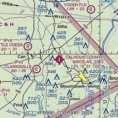
| Sectional chart |
|---|
|
| Airport distance calculator |
|---|
|
|
| Sunrise and sunset |
|---|
|
Times for 03-Nov-2025
| | Local
(UTC-6) | | Zulu
(UTC) |
|---|
| Morning civil twilight | | 05:33 | | 11:33 |
| Sunrise | | 05:58 | | 11:58 |
| Sunset | | 16:51 | | 22:51 |
| Evening civil twilight | | 17:15 | | 23:15 |
|
| Current date and time |
|---|
| Zulu (UTC) | 03-Nov-2025 14:12:54 |
|---|
| Local (UTC-6) | 03-Nov-2025 08:12:54 |
|---|
|
| METAR |
|---|
KMAI
21nm N | 031353Z AUTO 34006KT 10SM CLR 10/06 A3028 RMK AO2 SLP252 T01000061
|
K2J9
30nm E | 031355Z AUTO VRB04KT 10SM CLR 11/08 A3029 RMK AO2
|
KBCR
33nm NW | 031358Z AUTO 33005KT 10SM CLR 11/06 A3031 RMK AO2 SLP248 T01110056
|
K17J
33nm N | 031355Z AUTO 02009KT 10SM CLR 10/05 A3031 RMK AO2
|
KTDR
34nm SW | 031355Z AUTO 02012KT 10SM CLR 12/07 A3023 RMK AO2 SLP238 T01180069 $
|
KPAM
34nm SW | 031355Z AUTO 02009KT 10SM CLR 12/07 A3027 RMK AO2 SLP254 T01160065 $
|
KECP
36nm W | 031353Z 36006KT 10SM CLR 11/07 A3027 RMK AO2 SLP263 T01060072
|
KBGE
38nm NE | 031355Z AUTO 36010KT CLR 10/07 A3029 RMK AO2 PWINO T00990072
|
KTLH
40nm E | 031353Z 35007KT 10SM CLR 11/07 A3026 RMK AO2 SLP246 T01060072
|
|
| TAF |
|---|
KPAM
34nm SW | 031200Z 0312/0418 36009KT 9999 SKC QNH3017INS BECMG 0413/0414 05009KT 9999 SKC QNH3029INS TX20/0319Z TN10/0312Z
|
KECP
36nm W | 031121Z 0312/0412 32003KT P6SM SKC FM031800 36010G15KT P6SM SKC
|
KTLH
40nm E | 031121Z 0312/0412 34004KT P6SM SKC FM031800 36009KT P6SM SKC
|
|
| NOTAMs |
|---|
NOTAMs are issued by the DoD/FAA and will open in a separate window not controlled by AirNav.
|
|


