FAA INFORMATION EFFECTIVE 14 MAY 2026
Location
| FAA Identifier: | GKJ |
| Lat/Long: | 41-37-35.5000N 080-12-53.0000W
41-37.591667N 080-12.883333W
41.6265278,-80.2147222
(estimated) |
| Elevation: | 1399.4 ft. / 426.5 m (surveyed) |
| Variation: | 08W (1990) |
| From city: | 3 miles W of MEADVILLE, PA |
| Time zone: | UTC -4 (UTC -5 during Standard Time) |
| Zip code: | 16335 |
Airport Operations
| Airport use: | Open to the public |
| Activation date: | 04/1938 |
| Control tower: | no |
| ARTCC: | CLEVELAND CENTER |
| FSS: | ALTOONA FLIGHT SERVICE STATION |
| NOTAMs facility: | GKJ (NOTAM-D service available) |
| Attendance: | 0800-1600 |
| Wind indicator: | lighted |
| Segmented circle: | no |
| Lights: | ACTVT MALS RWY 25; PAPI RWY 25; VASI RWY 07; MIRL RWY 07/25 - CTAF. |
| Beacon: | white-green (lighted land airport)
Operates sunset to sunrise. |
| Landing fee: | yes, LANDING FEES VARY, CALL AIRPORT AT 814-333-2677 FOR FEE AMOUNTS. |
Airport Communications
| CTAF/UNICOM: | 123.0 |
| WX ASOS: | 126.375 (814-337-2590) |
| YOUNGSTOWN APPROACH: | 133.95 |
| YOUNGSTOWN DEPARTURE: | 133.95 |
| CLEARANCE DELIVERY: | 124.95 |
- APCH/DEP SVC PRVDD BY CLEVELAND ARTCC (ZOB) ON FREQS 120.775/298.95 (CHARDON RCAG) WHEN YOUNGSTOWN APCH CTL CLSD.
Nearby radio navigation aids
| VOR radial/distance | | VOR name | | Freq | | Var |
|---|
| FKLr311/(19.6) | | FRANKLIN VOR | | 109.60 | | 06W |
| NDB name | | Hdg/Dist | | Freq | | Var | | ID |
|---|
| CASTLE | | 023/37.3 | | 272 | | 09W | | UCP | ..- -.-. .--. |
Airport Services
| Fuel available: | 100LL JET-A
A:JET A ANTI-ICE AVBL O/R. |
| Parking: | hangars and tiedowns |
| Airframe service: | MAJOR |
| Powerplant service: | MAJOR |
| Bottled oxygen: | NONE |
| Bulk oxygen: | NONE |
Runway Information
Runway 7/25
| Dimensions: | 5001 x 75 ft. / 1524 x 23 m |
| Surface: | asphalt, in good condition |
| Weight bearing capacity: | | Single wheel: | 12.0 | | Double wheel: | 60.0 |
|
| Runway edge lights: | medium intensity |
| RUNWAY 7 | | RUNWAY 25 |
| Latitude: | 41-37.392610N | | 41-37.789070N |
| Longitude: | 080-13.364795W | | 080-12.403083W |
| Elevation: | 1392.4 ft. | | 1396.6 ft. |
| Traffic pattern: | left | | left |
| Runway heading: | 069 magnetic, 061 true | | 249 magnetic, 241 true |
| Markings: | nonprecision, in good condition | | nonprecision, in good condition |
| Visual slope indicator: | 4-box VASI on left (3.00 degrees glide path) | | 4-light PAPI on left (3.00 degrees glide path) |
| Approach lights: | | | MALS: 1,400 foot medium intensity approach lighting system |
| Touchdown point: | yes, no lights | | yes, no lights |
| Instrument approach: | | | LOCALIZER |
| Obstructions: | 50 ft. trees, 1089 ft. from runway, 335 ft. left of centerline, 17:1 slope to clear | | none |
Airport Ownership and Management from official FAA records
| Ownership: | Publicly-owned |
| Owner: | CCRAA
16306 CORPORATE DR
MEADVILLE, PA 16335
Phone 814-333-2677
CRAWFORD COUNTY REGIONAL AIRPORT AUTHORITY. |
| Manager: | KEITH A. CHIOCCO
16306 CORPORATE DR
MEADVILLE, PA 16335
Phone 814-720-2261 |
Additional Remarks
| - | BIRDS, DEER & GND HOGS ON & INVOF ARPT. |
| - | TRML BLDG CLSD MAJOR HOL. CALL AHD TO COORD SVC. |
| - | FOR CD CTC YOUNGSTOWN APCH AT 330-856-4806, WHEN APCH CLSD CTC CLEVELAND ARTCC AT 440-774-0232. |
| - | DURING WINTER MONTHS RWY & AFLD PAVEMENTS MAY NOT BE MNTND, CALL FOR FICON. |
| - | DURG SUMMER MONTHS MOWING OPS ADJ TO RWY IN PROG DLY. |
| - | TURF OPNS AREA LCTD N OF RWY & MKD W/CONES. TURF OPNS AUTH JUN THRU OCT FM SR TO SS UNLESS CLSD BY NOTAM. TURF OPNS NOT AUTH DURG INCLEMENT WX. CTC AMGR FOR TURF OPNS AREA CONDS. |
| - | ADNL INFO ON TURF OPNS PROC CAN BE FOUND ON ARPT WEBSITE. |
Instrument Procedures
NOTE: All procedures below are presented as PDF files. If you need a reader for these files, you should download the free Adobe Reader.NOT FOR NAVIGATION. Please procure official charts for flight.
FAA instrument procedures published for use from 14 May 2026 at 0901Z to 11 June 2026 at 0900Z.
IAPs - Instrument Approach Procedures |
|---|
| RNAV (GPS) RWY 07 | |
download (191KB) |
| RNAV (GPS) RWY 25 | |
download (191KB) |
| LOC RWY 25 | |
download (207KB) |
| NOTE: Special Alternate Minimums apply | |
download (44KB) |
| NOTE: Special Take-Off Minimums/Departure Procedures apply | |
download (149KB) |
Other nearby airports with instrument procedures:
4G1 - Greenville Municipal Airport (13 nm SW)
6G1 - Titusville Airport (21 nm E)
KFKL - Venango Regional Airport (22 nm SE)
KHZY - Northeast Ohio Regional Airport (23 nm NW)
KERI - Erie International Airport/Tom Ridge Field (27 nm N)
|
|

Road maps at:
MapQuest
Bing
Google
| Aerial photo |
|---|
WARNING: Photo may not be current or correct

Do you have a better or more recent aerial photo of Port Meadville Airport that you would like to share? If so, please send us your photo.
|
| Sectional chart |
|---|
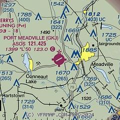
|
| Airport distance calculator |
|---|
|
|
| Sunrise and sunset |
|---|
|
Times for 17-May-2026
| | Local
(UTC-4) | | Zulu
(UTC) |
|---|
| Morning civil twilight | | 05:29 | | 09:29 |
| Sunrise | | 06:00 | | 10:00 |
| Sunset | | 20:34 | | 00:34 |
| Evening civil twilight | | 21:06 | | 01:06 |
|
| Current date and time |
|---|
| Zulu (UTC) | 17-May-2026 15:38:09 |
|---|
| Local (UTC-4) | 17-May-2026 11:38:09 |
|---|
|
| METAR |
|---|
| KGKJ | 171453Z AUTO 19006KT 10SM FEW013 21/17 A3011 RMK AO2 SLP191 T02110172 50008
|
|
| TAF |
|---|
KFKL
22nm SE | 171127Z 1712/1812 22006KT 2SM BR BKN004 FM171400 23006KT 6SM BR BKN015 FM171600 23008KT P6SM SCT015 BKN040 PROB30 1717/1720 6SM -SHRA BR FM172000 22006KT P6SM SCT040 BKN250
|
KERI
27nm N | 171134Z 1712/1812 22007KT P6SM BKN250 FM171900 29006KT P6SM SCT045 FM180000 16008KT P6SM FEW050 SCT100
|
|
| NOTAMs |
|---|
NOTAMs are issued by the DoD/FAA and will open in a separate window not controlled by AirNav.
|
|

