FAA INFORMATION EFFECTIVE 21 MARCH 2024
Location
| FAA Identifier: | IFP |
| Lat/Long: | 35-09-16.6120N 114-33-33.5960W
35-09.276867N 114-33.559933W
35.1546144,-114.5593322
(estimated) |
| Elevation: | 707.1 ft. / 215.5 m (surveyed) |
| Variation: | 12E (2005) |
| From city: | 1 mile N of BULLHEAD CITY, AZ |
| Time zone: | UTC -7 (year round; does not observe DST) |
| Zip code: | 86429 |
Airport Operations
| Airport use: | Open to the public |
| Control tower: | yes |
| ARTCC: | LOS ANGELES CENTER |
| FSS: | PRESCOTT FLIGHT SERVICE STATION |
| NOTAMs facility: | IFP (NOTAM-D service available) |
| Attendance: | CONTINUOUS
SVCS & FUEL 0600-2200 - 122.85; AFT HR NA. |
| Wind indicator: | lighted |
| Segmented circle: | yes |
| Lights: | ACTVT REIL RWY 16/34; MIRL RWY 16/34 - CTAF. |
| Beacon: | white-green (lighted land airport)
Operates sunset to sunrise. |
| Fire and rescue: | ARFF index B |
Airport Communications
| CTAF: | 123.9 |
| ATIS: | 119.825 |
| WX AWOS-3PT: | 119.825 (928-754-4462) |
| BULLHEAD TOWER GROUND: | 118.25 [0800-1800] |
| BULLHEAD TOWER TOWER: | 123.9 [0800-1800] |
- APCH/DEP CTL SVC PRVDD BY LOS ANGELES ARTCC (ZLA) ON FREQS 134.65/360.65 (NELSON RCAG).
- LOS ANGELES ARTCC CLNC DEL 118.25 WHEN TOWER CLSD.
- ATIS BROADCASTS DURING TOWER HOURS OF OPERATION. AFTER TOWER HOURS OF OPERATION BROADCAST WILL REVERT TO AWOS-3PT USING THE SAME FREQUENCY.
Nearby radio navigation aids
| VOR radial/distance | | VOR name | | Freq | | Var |
|---|
| EEDr335/23.7 | | NEEDLES VORTAC | | 115.20 | | 15E |
| GFSr072/30.3 | | GOFFS VORTAC | | 114.40 | | 15E |
| IGMr243/31.3 | | KINGMAN VOR/DME | | 108.80 | | 15E |
Airport Services
| Fuel available: | 100LL JET-A |
| Parking: | hangars and tiedowns |
| Bulk oxygen: | HIGH/LOW |
Runway Information
Runway 16/34
| Dimensions: | 8501 x 150 ft. / 2591 x 46 m |
| Surface: | asphalt/grooved, in good condition |
| Weight bearing capacity: | | PCN 52 /F/A/X/T | | Single wheel: | 75.0 | | Double wheel: | 200.0 | | Double tandem: | 400.0 |
|
| Runway edge lights: | medium intensity |
| RUNWAY 16 | | RUNWAY 34 |
| Latitude: | 35-09.976088N | | 35-08.577635N |
| Longitude: | 114-33.612613W | | 114-33.507263W |
| Elevation: | 625.5 ft. | | 707.1 ft. |
| Traffic pattern: | right | | left |
| Runway heading: | 164 magnetic, 176 true | | 344 magnetic, 356 true |
| Declared distances: | TORA:8500 TODA:8500 ASDA:8500 LDA:8500 | | TORA:8500 TODA:8500 ASDA:8500 LDA:8500 |
| Markings: | nonprecision, in good condition | | nonprecision, in good condition |
| Visual slope indicator: | 4-light PAPI on left (3.00 degrees glide path) | | 4-light PAPI on left (3.00 degrees glide path) |
| Runway end identifier lights: | yes | | yes |
| Touchdown point: | yes, no lights | | yes, no lights |
| Obstructions: | 123 ft. pole, 3200 ft. from runway, 550 ft. left of centerline, 24:1 slope to clear | | none |
Airport Ownership and Management from official FAA records
| Ownership: | Publicly-owned |
| Owner: | MOHAVE COUNTY
BOX 390
KINGMAN, AZ 86402 |
| Manager: | JAMES SCHELLER
2550 LAUGHLIN VIEW DR
BULLHEAD CITY, AZ 86429
Phone 928-754-2134 X24
941-323-2178. |
Airport Operational Statistics
| Aircraft based on the field: | | 28 | | Single engine airplanes: | | 21 | | Multi engine airplanes: | | 3 | | Helicopters: | | 4 |
| |  | |
| Aircraft operations: avg 28/day * | | 54% | transient general aviation | | 21% | air taxi | | 11% | local general aviation | | 8% | commercial | | 6% | military | | * for 12-month period ending 01 January 2022 | |
Additional Remarks
| A30A-16 | 66 FT PLINE PARL TO RWY 625 FT L 1300 FT FM RWY END. |
| - | MTNS NW, NE, E AND SE. RISING TRRN N & S OF RWY ENDS. |
| - | NOISE SENSITIVE AREAS NE & SE. |
| - | SFC COND UNMNT 0600Z-1200Z. |
| - | TWY A5 BTN TWY A & GEN AVN APRON LTD TO WINGSPAN LESS THAN 79 FT. |
| - | RADAR SVC BLW 6000 FT NA. |
| - | GA LNDG FEE - 928-754-2134. |
| - | TPA FOR LIGHT ACFT 999 FT AGL, TPA FOR HIGH PERFORMANCE ACFT 1499 FT AGL. |
| - | TWY ALPHA 4 LTD TO WINGSPANS LESS THAN 79 FT. |
| - | CTN: LRG COML OPS AFT ATCT HRS; BIRDS ON & INVOF ARPT SEP-DEC. |
Instrument Procedures
NOTE: All procedures below are presented as PDF files. If you need a reader for these files, you should download the free Adobe Reader.NOT FOR NAVIGATION. Please procure official charts for flight.
FAA instrument procedures published for use from 21 March 2024 at 0901Z to 18 April 2024 at 0900z.
IAPs - Instrument Approach Procedures |
|---|
| RNAV (GPS) RWY 16 | |
download (427KB) |
| RNAV (GPS) RWY 34 | |
download (307KB) |
| VOR RWY 34 | |
download (265KB) |
| NOTE: Special Alternate Minimums apply | |
download (141KB) |
| NOTE: Special Take-Off Minimums/Departure Procedures apply | |
download (113KB) |
Other nearby airports with instrument procedures:
KEED - Needles Airport (24 nm S)
KIGM - Kingman Airport (31 nm E)
KHII - Lake Havasu City Airport (36 nm S)
KBVU - Boulder City Municipal Airport (50 nm N)
KHND - Henderson Executive Airport (57 nm NW)
|
|

Road maps at:
MapQuest
Bing
Google
| Aerial photo |
|---|
WARNING: Photo may not be current or correct
 Photo courtesy of Mark Holtzman
West Coast Aerial Photography
Photo taken 11-Feb-2018
looking northeast.
Do you have a better or more recent aerial photo of Laughlin/Bullhead International Airport that you would like to share? If so, please send us your photo.
|
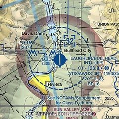
| Sectional chart |
|---|
|
 Download PDF
of official airport diagram from the FAA
| Airport distance calculator |
|---|
|
|
| Sunrise and sunset |
|---|
|
Times for 16-Apr-2024
| | Local
(UTC-7) | | Zulu
(UTC) |
|---|
| Morning civil twilight | | 05:38 | | 12:38 |
| Sunrise | | 06:04 | | 13:04 |
| Sunset | | 19:11 | | 02:11 |
| Evening civil twilight | | 19:38 | | 02:38 |
|
| Current date and time |
|---|
| Zulu (UTC) | 17-Apr-2024 06:00:49 |
|---|
| Local (UTC-7) | 16-Apr-2024 23:00:49 |
|---|
|
| METAR |
|---|
KIFP
12nm E | 170535Z AUTO 12006KT 10SM CLR 24/M04 A2991 RMK AO2
|
|
| TAF |
|---|
KIFP
12nm E | 170520Z 1706/1806 VRB06KT P6SM SKC FM172000 21010KT P6SM SCT250 FM180300 16008KT P6SM BKN250
|
|
| NOTAMs |
|---|
NOTAMs are issued by the DoD/FAA and will open in a separate window not controlled by AirNav.
|
|


