FAA INFORMATION EFFECTIVE 25 DECEMBER 2025
Location
| FAA Identifier: | AIV |
| Lat/Long: | 33-06-24.2800N 088-11-49.8300W
33-06.404667N 088-11.830500W
33.1067444,-88.1971750
(estimated) |
| Elevation: | 150 ft. / 45.7 m (surveyed) |
| Variation: | 02W (2015) |
| From city: | 2 miles SW of ALICEVILLE, AL |
| Time zone: | UTC -6 (UTC -5 during Daylight Saving Time) |
| Zip code: | 35442 |
Airport Operations
| Airport use: | Open to the public |
| Activation date: | 10/1961 |
| Control tower: | no |
| ARTCC: | MEMPHIS CENTER |
| FSS: | ANNISTON FLIGHT SERVICE STATION |
| NOTAMs facility: | ANB (NOTAM-D service available) |
| Attendance: | UNATNDD |
| Wind indicator: | lighted |
| Segmented circle: | yes |
| Lights: | ACTVT REILS RWY 06 & 24; MIRL RWY 06/24 - CTAF. |
| Beacon: | white-green (lighted land airport)
Operates sunset to sunrise. |
Airport Communications
| CTAF/UNICOM: | 122.8 |
| COLUMBUS APPROACH: | 135.6 |
| COLUMBUS DEPARTURE: | 135.6 |
- APCH/DEP SVC PRVDD BY MEMPHIS ARTCC ON FREQS 127.1/269.4 (COLUMBUS RCAG) WHEN COLUMBUS APCH CTL CLSD.
Nearby radio navigation aids
| VOR radial/distance | | VOR name | | Freq | | Var |
|---|
| IGBr141/27.7 | | BIGBEE VORTAC | | 116.20 | | 04E |
| CBMr159/34.3 | | CALEDONIA VORTAC | | 115.20 | | 00E |
Airport Services
| Fuel available: | 100LL |
| Parking: | tiedowns |
| Airframe service: | NONE |
| Powerplant service: | NONE |
| Bottled oxygen: | NONE |
| Bulk oxygen: | NONE |
Runway Information
Runway 6/24
| Dimensions: | 5001 x 80 ft. / 1524 x 24 m |
| Surface: | asphalt, in good condition |
| Runway edge lights: | medium intensity |
| Runway edge markings: | MARKINGS FADED. |
| RUNWAY 6 | | RUNWAY 24 |
| Latitude: | 33-06.208833N | | 33-06.600500N |
| Longitude: | 088-12.261667W | | 088-11.399333W |
| Elevation: | 142.8 ft. | | 149.8 ft. |
| Traffic pattern: | left | | left |
| Runway heading: | 064 magnetic, 062 true | | 244 magnetic, 242 true |
| Markings: | nonprecision, in poor condition | | nonprecision, in poor condition |
| Runway end identifier lights: | yes | | yes |
| Touchdown point: | yes, no lights | | yes, no lights |
| Obstructions: | 30 ft. tree, 733 ft. from runway, 104 ft. right of centerline, 17:1 slope to clear | | 81 ft. tree, lighted, 1983 ft. from runway, 73 ft. right of centerline, 22:1 slope to clear |
Airport Ownership and Management from official FAA records
| Ownership: | Publicly-owned |
| Owner: | CITY OF ALICEVILLE
451 MEMORIAL DR
ALICEVILLE, AL 35442
Phone 205-373-6611
ALT PHONE NR 205-315-1057. |
| Manager: | LARRY POTTS
11135 HWY 17
ALICEVILLE, AL 35442
Phone 205-373-0446 |
Additional Remarks
| - | TWY LGTS FOR TWY TURNOFF ONLY. |
| - | FOR CD CTC COLUMBUS APCH AT 662-434-3044. |
Instrument Procedures
NOTE: All procedures below are presented as PDF files. If you need a reader for these files, you should download the free Adobe Reader.NOT FOR NAVIGATION. Please procure official charts for flight.
FAA instrument procedures published for use from 25 December 2025 at 0901z to 22 January 2026 at 0900z.
IAPs - Instrument Approach Procedures |
|---|
| RNAV (GPS) RWY 06 | |
download (207KB) |
| RNAV (GPS) RWY 24 | |
download (205KB) |
| NOTE: Special Take-Off Minimums/Departure Procedures apply | |
download (250KB) |
Other nearby airports with instrument procedures:
3M8 - North Pickens Airport (19 nm NE)
KUBS - Columbus-Lowndes County Airport (23 nm NW)
KGTR - Golden Triangle Regional Airport (28 nm NW)
KTCL - Tuscaloosa National Airport (30 nm E)
M51 - Oktibbeha Airport (34 nm NW)
|
|

Road maps at:
MapQuest
Bing
Google
| Aerial photo |
|---|
WARNING: Photo may not be current or correct
 Photo by David White
Photo taken 07-Nov-2019
looking southwest.
Photo by David White
Photo taken 07-Nov-2019
looking southwest.
Do you have a better or more recent aerial photo of George Downer Airport that you would like to share? If so, please send us your photo.
|
| Sectional chart |
|---|
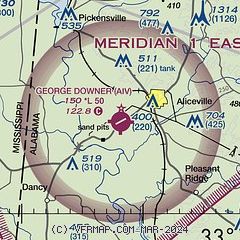
|
| Airport distance calculator |
|---|
|
|
| Sunrise and sunset |
|---|
|
Times for 20-Jan-2026
| | Local
(UTC-6) | | Zulu
(UTC) |
|---|
| Morning civil twilight | | 06:29 | | 12:29 |
| Sunrise | | 06:56 | | 12:56 |
| Sunset | | 17:12 | | 23:12 |
| Evening civil twilight | | 17:39 | | 23:39 |
|
| Current date and time |
|---|
| Zulu (UTC) | 20-Jan-2026 09:15:51 |
|---|
| Local (UTC-6) | 20-Jan-2026 03:15:51 |
|---|
|
| METAR |
|---|
KGTR
28nm NW | 200856Z AUTO 35005KT 10SM CLR M03/M08 A3048 RMK AO2 SLP326 T10281078 53017 FZRANO $
|
KTCL
30nm E | 200853Z AUTO 00000KT 10SM CLR M02/M04 A3046 RMK AO2 SLP315 T10171039 51022
|
KCBM
34nm N | 200855Z 01006KT 10SM CLR M02/M11 A3042 RMK AO2A SLP305 T10171113 52013 $
|
KNJW
37nm SW | 200857Z AUTO 01004KT 10SM CLR M02/M06 A3046 RMK AO2 SLP233 T10171061 51010
|
KSTF
38nm NW | 200855Z AUTO 00000KT 10SM FEW065 M02/M10 A3045 RMK AO2
|
KNMM
39nm SW | 200856Z AUTO 35003KT 10SM CLR M01/M04 A3044 RMK AO2 SLP321 T10061044 51012 $
|
KDYA
40nm S | 200855Z AUTO 00000KT 7SM CLR M03/M03 A3044 RMK AO2 T10271028
|
KLMS
44nm W | 200900Z AUTO 01008KT 10SM BKN065 SCT120 M02/M08 A3046 RMK AO2
|
KM40
48nm N | 200855Z AUTO 36006KT 10SM CLR M03/M11 A3049 RMK AO2
|
|
| TAF |
|---|
KGTR
28nm NW | 200526Z 2006/2106 33005KT P6SM SKC FM202000 14005KT P6SM SKC
|
KTCL
30nm E | 200520Z 2006/2106 VRB04KT P6SM FEW250 FM201500 36004KT P6SM SKC FM210100 VRB02KT P6SM SKC
|
|
| NOTAMs |
|---|
NOTAMs are issued by the DoD/FAA and will open in a separate window not controlled by AirNav.
|
|

