FAA INFORMATION EFFECTIVE 30 OCTOBER 2025
Location
| FAA Identifier: | BUR |
| Lat/Long: | 34-12-02.5000N 118-21-31.2000W
34-12.041667N 118-21.520000W
34.2006944,-118.3586667
(estimated) |
| Elevation: | 778 ft. / 237.1 m (surveyed) |
| Variation: | 12E (2020) |
| From city: | 3 miles NW of BURBANK, CA |
| Time zone: | UTC -8 (UTC -7 during Daylight Saving Time) |
| Zip code: | 91505 |
Airport Operations
| Airport use: | Open to the public |
| Activation date: | 12/1942 |
| Control tower: | yes |
| ARTCC: | LOS ANGELES CENTER |
| FSS: | HAWTHORNE FLIGHT SERVICE STATION |
| NOTAMs facility: | BUR (NOTAM-D service available) |
| Attendance: | CONTINUOUS |
| Wind indicator: | lighted |
| Segmented circle: | no |
| Beacon: | white-green (lighted land airport)
Operates sunset to sunrise. |
| Fire and rescue: | ARFF index C |
Airport Communications
| UNICOM: | 122.95 |
| WX ASOS: | PHONE 818-841-1384 |
| BURBANK GROUND: | 123.9 348.6 |
| BURBANK TOWER: | 118.7 132.325 ;HELICOPTERS 254.3 |
| SOCAL APPROACH: | 120.4 ;VNY 280-BUR 050, NORTH 124.6 ;SOUTH BTN BUR 150-VNY 160 134.2 ;160-280 VNY, WEST 135.05 ;050-150 BUR |
| SOCAL DEPARTURE: | 120.4 ;VNY 280-BUR 050, NORTH 124.6 ;SOUTH BTN BUR 150-VNY 160 134.2 ;160-280 VNY, WEST 135.05 ;050-150 BUR |
| CLEARANCE DELIVERY: | 118.0 348.6 |
| CLASS B: | 128.75 |
| CLASS C: | 120.4 ;VNY 280-BUR 050 124.6 ;SOUTH BTN BUR 150-VNY 160 134.2 ;160-280 VNY 135.05 ;050-150 BUR |
| D-ATIS: | 134.5 135.125 ;ARR VIA FIM/PMD VORTAC ONLY |
| ELMOO DP: | 135.05 |
| EMERG: | 121.5 243.0 |
| FERNANDO STAR: | 134.2 |
| IC: | 120.4 ;VNY 280-BUR 050, NORTH 134.2 ;160-280 VNY, WEST |
| JANNY STAR: | 120.4 |
| LYNXX STAR: | 120.4 |
| OROSZ DP: | 124.6 |
| ROKKR STAR: | 128.75 |
| SLAPP DP: | 124.6 |
| THRNE STAR: | 126.7 |
| VAN NUYS DP: | 124.6 |
| VVERA DP: | 124.6 |
| WEESL STAR: | 120.4 |
| WX AWOS-3PT at WHP (4 nm NW): | 132.1 (818-899-9820) |
| WX ASOS at VNY (7 nm W): | PHONE 818-904-9213 |
| WX ASOS at SMO (12 nm SW): | PHONE 310-392-6453 |
| WX ASOS at LAX (16 nm S): | PHONE 310-602-6051 |
| WX ASOS at HHR (17 nm S): | PHONE 310-973-8930 |
| WX AWOS-3PT at EMT (17 nm SE): | 118.75 ((626) 444-1107) |
| WX AWOS-3PT at CPM (20 nm S): | 127.150 (310-631-3022) |
- SAID IN USE. OPERATE TRANSPONDERS WITH ALTITUDE REPORTING MODE AND ADS-B (IF EQUIPPED) ENABLED ON ALL AIRPORT SURFACES.
Nearby radio navigation aids
| VOR radial/distance | | VOR name | | Freq | | Var |
|---|
| VNYr087/6.7 | | VAN NUYS VOR/DME | | 113.10 | | 15E |
| SMOr008/12.4 | | SANTA MONICA VOR/DME | | 110.80 | | 15E |
| LAXr358/16.5 | | LOS ANGELES VORTAC | | 113.60 | | 15E |
| FIMr095/27.5 | | FILLMORE VORTAC | | 112.50 | | 15E |
| SLIr314/29.3 | | SEAL BEACH VORTAC | | 115.70 | | 15E |
| POMr269/29.3 | | POMONA VORTAC | | 110.40 | | 15E |
| PMDr194/29.7 | | PALMDALE VORTAC | | 115.55 | | 15E |
| LHSr145/30.9 | | LAKE HUGHES VORTAC | | 114.35 | | 15E |
| VTUr066/34.7 | | VENTURA VOR/DME | | 116.55 | | 15E |
| CMAr076/36.5 | | CAMARILLO VOR/DME | | 115.80 | | 15E |
Airport Services
| Fuel available: | 100LL JET-A JET-A+ UL94 |
| Parking: | hangars |
| Airframe service: | MAJOR |
| Powerplant service: | MAJOR |
| Bottled oxygen: | HIGH |
| Bulk oxygen: | HIGH |
Runway Information
Runway 15/33
| Dimensions: | 6886 x 150 ft. / 2099 x 46 m |
| Surface: | asphalt/concrete/grooved, in excellent condition |
| Weight bearing capacity: | | Single wheel: | 120.0 | | Double wheel: | 201.0 | | Double tandem: | 352.0 | | Dual double tandem: | 839.0 |
|
| Runway edge lights: | medium intensity |
| RUNWAY 15 | | RUNWAY 33 |
| Latitude: | 34-12.740680N | | 34-11.634312N |
| Longitude: | 118-21.627643W | | 118-21.322208W |
| Elevation: | 778.0 ft. | | 694.5 ft. |
| Traffic pattern: | right | | left |
| Runway heading: | 155 magnetic, 167 true | | 335 magnetic, 347 true |
| Displaced threshold: | 909 ft. | | 350 ft. |
| Declared distances: | TORA:6885 TODA:6885 ASDA:6885 LDA:5976 | | TORA:6885 TODA:6885 ASDA:6885 LDA:6535 |
| Markings: | nonprecision, in good condition | | nonprecision, in good condition |
| Visual slope indicator: | 4-light PAPI on left (3.25 degrees glide path)
UNUSBL BYD 5 DEGS LEFT OF CNTRLN. | | 4-light PAPI on left (3.20 degrees glide path)
PAPI UNUSBL BYD 2 DEG RIGHT OF CNTRLN. |
| Runway end identifier lights: | yes | | yes |
| Touchdown point: | yes, no lights | | yes, no lights |
| Obstructions: | 30 ft. rr, 200 ft. from runway, 250 ft. left of centerline
+15 FT ROAD 100-200 FT FROM RY END; +14 FT BLAST FENCE; MULTIPLE LIGHT STANDARDS 15 FT FROM END OF RY. | | 31 ft. pole, 201 ft. from runway, 240 ft. right of centerline
+20 FT POLE 198 FT FROM RY THR; +14 FT BLAST FENCE AT THR. |
Runway 8/26
| Dimensions: | 5802 x 150 ft. / 1768 x 46 m |
| Surface: | asphalt/concrete/grooved, in excellent condition |
| Weight bearing capacity: | | Single wheel: | 120.0 | | Double wheel: | 201.0 | | Double tandem: | 352.0 | | Dual double tandem: | 839.0 |
|
| Runway edge lights: | high intensity |
| RUNWAY 8 | | RUNWAY 26 |
| Latitude: | 34-11.874657N | | 34-11.859023N |
| Longitude: | 118-22.148575W | | 118-20.997595W |
| Elevation: | 727.4 ft. | | 697.3 ft. |
| Traffic pattern: | right | | left |
| Runway heading: | 079 magnetic, 091 true | | 259 magnetic, 271 true |
| Declared distances: | TORA:5801 TODA:5801 ASDA:5801 LDA:5801 | | TORA:5801 TODA:5801 ASDA:5801 LDA:5801 |
| Markings: | precision, in good condition | | nonprecision, in good condition |
| Visual slope indicator: | 4-light PAPI on left (3.00 degrees glide path)
PAPI UNUSBL BYD 6.5 DEGS LEFT OF RWY CNTRLN. | | |
| RVR equipment: | touchdown | | rollout |
| Approach lights: | MALSR: 1,400 foot medium intensity approach lighting system with runway alignment indicator lights | | |
| Runway end identifier lights: | no | | yes |
| Touchdown point: | yes, no lights | | yes, no lights |
| Instrument approach: | ILS | | |
| Obstructions: | 14 ft. road, 300 ft. from runway, 7:1 slope to clear | | 40 ft. pole, 245 ft. from runway, 410 ft. right of centerline, 1:1 slope to clear
+28' SIGN 90 FT FM RY THLD, +14 FT BLAST FENCE AT THLD. |
Airport Ownership and Management from official FAA records
| Ownership: | Publicly-owned |
| Owner: | BURBANK-GLENDALE-PASADENA APT
2627 HOLLYWOOD WAY
BURBANK, CA 91505
Phone 818-840-8840 |
| Manager: | THOMAS HENDERSON, DIRECTOR OF OPS
2627 HOLLYWOOD WAY
BURBANK, CA 91505
Phone 818-840-8830 |
Additional Remarks
| A39-15/33 | PCR VALUE: 685/F/C/X/T |
| A39-08/26 | PCR VALUE: 611/F/C/X/T |
| E60-08 | ENGINEERED MATERIAL ARRESTING SYSTEM (EMAS) 170 FT LENGTH BY 350 FT WIDTH LCTD AT THE DER 08. |
| - | ACFT IN TFC PAT (1225 FT AGL) AT WHITEMAN AIRPARK 5 MI NW. |
| - | HANG GLIDER ACTIVITY BTN 5 & 10 NM NORTH OF ARPT 6000 FT AGL SR-SS. |
| - | TWY G RSTRD TO ACFT WITH WINGSPAN OF 95 FT OR LESS. |
| - | POWER ENGINE RUN-UPS FOR ACFT GTR THAN 1200 LBS PROHIBITED IN ALL AREAS EXC ON TWY D RUN-UP AREA OR AS COORDINATED WITH ATCT. |
| - | 14 FT BLAST FENCE 35 FT FM DEP END RY 15. |
| - | 14 FT BLAST FENCE 93 FT FM DEP END RY 33. |
| - | 8 FT BLAST FENCE 260 FT FM DEP END OF RY 26. |
| - | 14 FT BLAST FENCE 256 FT FROM DEP END RY 08. |
| - | TWY A RESTRICTED TO ACFT WITH WINGSPAN OF 171 FT OR LESS. |
| - | PILOTS SHOULD CALL AHEAD FOR ARPT NOISE RULES (818) 840-8840. |
| - | RSTRNS AND FINES EFF 2200-0700 FOR STAGE 2 JETS, CERTAIN PROPS, RUN-UPS AND FLT TRG ACT, CALL (818) 840-8840 BFR OPRG. |
| - | TWY B RESTRICTED TO ACFT WITH WINGSPAN OF 79 FT OR LESS BEGINNING 300 FT NORTH OF TWY D AND CONTINUING NORTH. |
| - | NO GA ACFT PARKING AT TERMINAL RAMP. |
| - | TURBULENT CONDS NEAR ARPT AT TIMES OF HIGH WINDS FROM NORTH & EAST. DOWNDRAFTS/WINDSHEAR MAY OCCUR AT LIFTOFF OR ON FINAL. |
| - | ACFT WILL USE EASY PWR WHEN LVG ASGND GATE. CTN MUST BE USED WHEN TAXIING FM TRML AREA DUE TO CLOSE PROXIMITY TO THE TRML. PSNL AND GND EQUIP IN AREA. |
| - | ACFT WITH WINGSPAN GTR THAN 95 FT EXP BACK TAXI ON RWY 15/33 FOR A RWY 33 DEP. |
| - | ACFT RSTRD FROM TAXIING SB PAST GATE B1 ON TRML RAMP. |
| - | ACFT WITH WINGSPAN GTR THAN 79 FT RSTRD FROM USING TWY C W OF TWY C8. |
| - | RWY 26 CLSD TO TKOF/JET ACFT WITH FOUR OR MORE ENGS. |
| - | X-BLEED STARTS PROHIBITED IN ALL NON-MOVMT AREAS INCLG THE AIRLINE TRML RAMP. ATC MAY APV X-BLEED STARTS ON TWY A NORTH OF TWY D, ALL OTHER REQS MUST BE COORDD AND APVD BY OPS. |
| - | WHEN KBUR LDG RWY 08 USE CTN FOR TCAS RA DUE TO ACFT IN KVNY RWY 16L/34R TFC PAT (TPA 1802 MSL). |
| - | BIRD ACTIVITY NORTH END RY 15/33 AND WEST END RY 08/26. |
| - | RWY 08 CLSD TKOF ACFT GTR THAN 12500 LBS. |
Instrument Procedures
NOTE: All procedures below are presented as PDF files. If you need a reader for these files, you should download the free Adobe Reader.NOT FOR NAVIGATION. Please procure official charts for flight.
FAA instrument procedures published for use from 30 October 2025 at 0901Z to 27 November 2025 at 0900Z.
STARs - Standard Terminal Arrivals |
|---|
| FERNANDO SEVEN | |
2 pages:
[1] [2] (342KB) |
| JANNY FIVE (RNAV) | |
download (288KB) |
| LYNXX EIGHT | |
download (241KB) |
| ROKKR THREE (RNAV) | |
2 pages:
[1] [2] (374KB) |
| THRNE FOUR (RNAV) | |
2 pages:
[1] [2] (373KB) |
| WEESL ONE (RNAV) | |
download (165KB) |
IAPs - Instrument Approach Procedures |
|---|
| ILS Y OR LOC Y RWY 08 | |
download (455KB) |
| ILS Z OR LOC Z RWY 08 | |
download (465KB) |
| RNAV (RNP) Y RWY 08 | |
download (381KB) |
| RNAV (GPS) Z RWY 08 | |
download (324KB) |
| VOR RWY 08 | |
download (404KB) |
| FOUR STACKS VISUAL RWY 15 | |
download (162KB) |
| NOTE: Special Alternate Minimums apply | |
download (141KB) |
Departure Procedures |
|---|
| ELMOO NINE | |
download (186KB) |
| OROSZ TWO (RNAV) | |
download (248KB) |
| SLAPP TWO (RNAV) | |
2 pages:
[1] [2] (360KB) |
| VAN NUYS THREE | |
2 pages:
[1] [2] (409KB) |
| VVERA TWO (RNAV) | |
download (250KB) |
| NOTE: Special Take-Off Minimums/Departure Procedures apply | |
download (132KB) |
Other nearby airports with instrument procedures:
KWHP - Whiteman Airport (4 nm NW)
KVNY - Van Nuys Airport (7 nm W)
KSMO - Santa Monica Municipal Airport (12 nm SW)
KLAX - Los Angeles International Airport (16 nm S)
KHHR - Jack Northrop Field/Hawthorne Municipal Airport (17 nm S)
KEMT - San Gabriel Valley Airport (17 nm SE)
|
|

Road maps at:
MapQuest
Bing
Google
| Aerial photo |
|---|
WARNING: Photo may not be current or correct
 Photo courtesy of www.focalflight.com
Photo taken 04-Jul-2020
looking northeast.
Photo courtesy of www.focalflight.com
Photo taken 04-Jul-2020
looking northeast.
Do you have a better or more recent aerial photo of Bob Hope Airport that you would like to share? If so, please send us your photo.
|
| Sectional chart |
|---|
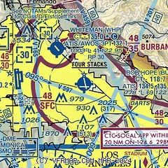
|
CAUTION: Diagram may not be current
 Download PDF
of official airport diagram from the FAA
| Airport distance calculator |
|---|
|
|
| Sunrise and sunset |
|---|
|
Times for 08-Nov-2025
| | Local
(UTC-8) | | Zulu
(UTC) |
|---|
| Morning civil twilight | | 05:55 | | 13:55 |
| Sunrise | | 06:21 | | 14:21 |
| Sunset | | 16:54 | | 00:54 |
| Evening civil twilight | | 17:20 | | 01:20 |
|
| Current date and time |
|---|
| Zulu (UTC) | 08-Nov-2025 22:28:26 |
|---|
| Local (UTC-8) | 08-Nov-2025 14:28:26 |
|---|
|
| METAR |
|---|
| KBUR | 082153Z 19005KT 10SM CLR 29/10 A2991 RMK AO2 SLP116 T02890100
|
KWHP
4nm NW | 082155Z 10004KT 10SM SKC 30/07 A2993
|
KVNY
6nm W | 082151Z 15006KT 10SM CLR 31/08 A2990 RMK AO2 SLP114 T03060078
|
KSMO
12nm S | 082204Z 25005KT 2 1/2SM HZ CLR 19/16 A2992 RMK AO2 T01890156
|
KMWS
15nm E | 082120Z 24001KT 22/04
|
KLAX
16nm S | 082153Z 27010KT 6SM HZ FEW005 21/16 A2992 RMK AO2 SLP130 T02060156
|
KHHR
17nm S | 082153Z 26007KT 7SM CLR 23/16 A2991 RMK AO2 SLP128 T02280161
|
KEMT
19nm SE | 082145Z 18008KT 10SM CLR 27/14 A2990
|
|
| TAF |
|---|
| KBUR | 081723Z 0818/0918 VRB03KT P6SM SKC FM082100 16007KT P6SM SKC FM090200 12005KT P6SM SKC FM090700 VRB03KT P6SM SKC
|
KVNY
6nm W | 081723Z 0818/0918 VRB03KT P6SM SKC FM082100 12007KT P6SM SKC FM090300 VRB03KT P6SM SKC
|
KSMO
12nm S | 081730Z 0818/0918 VRB03KT 5SM BR SCT005 FM082000 23006KT P6SM SKC FM090200 VRB03KT P6SM SKC FM090400 VRB03KT 2SM BR BKN004 FM091000 VRB03KT 1/2SM FG VV002 FM091600 VRB03KT 3SM BR BKN004
|
KLAX
16nm S | 081723Z 0818/0924 16004KT 5SM BR SCT006 FM081900 26010KT P6SM SCT008 FM090400 VRB03KT 4SM BR BKN005 FM091000 VRB03KT 1SM BR VCFG OVC002 FM091600 VRB03KT 3SM BR BKN004 FM091800 26010KT 6SM HZ SCT005
|
|
| NOTAMs |
|---|
NOTAMs are issued by the DoD/FAA and will open in a separate window not controlled by AirNav.
|
|


