FAA INFORMATION EFFECTIVE 11 JUNE 2026
Location
| FAA Identifier: | DXR |
| Lat/Long: | 41-22-17.5240N 073-28-55.8820W
41-22.292067N 073-28.931367W
41.3715344,-73.4821894
(estimated) |
| Elevation: | 456.7 ft. / 139.2 m (surveyed) |
| Variation: | 14W (1995) |
| From city: | 3 miles SW of DANBURY, CT |
| Time zone: | UTC -4 (UTC -5 during Standard Time) |
| Zip code: | 06810 |
Airport Operations
| Airport use: | Open to the public |
| Activation date: | 04/1940 |
| Control tower: | yes |
| ARTCC: | NEW YORK CENTER |
| FSS: | BRIDGEPORT FLIGHT SERVICE STATION |
| NOTAMs facility: | DXR (NOTAM-D service available) |
| Attendance: | 0700-DUSK |
| Pattern altitude: | 1699.7 ft. MSL
1743 FT AGL TURBOPROP/JET. |
| Wind indicator: | lighted |
| Segmented circle: | yes |
| Lights: | WHEN ATCT CLSD, ACTVT REIL RWY 08 & 26; MIRL RWY 08/26 - CTAF. |
| Beacon: | white-green (lighted land airport)
ROTG BCN LCTD ONE MILE SOUTH OF ARPT ON TOP OF A HILL. Operates sunset to sunrise. |
Airport Communications
| CTAF: | 119.4 |
| UNICOM: | 122.95 |
| ATIS: | 127.75 |
| WX ASOS: | 127.75 (203-791-8227) |
| DANBURY GROUND: | 121.6 [0700-2200] |
| DANBURY TOWER: | 119.4 [0700-2200] |
| NEW YORK APPROACH: | 126.4 |
| NEW YORK DEPARTURE: | 126.4 |
| CLEARANCE DELIVERY: | 128.6 ;WHEN DXR TWR CLSD |
| NOBBI STAR: | 120.8 |
| VALRE STAR: | 120.8 126.4 |
| WX AWOS-3PT at OXC (17 nm E): | 132.975 (203-262-1190) |
Nearby radio navigation aids
| VOR radial/distance | | VOR name | | Freq | | Var |
|---|
| CMKr051/7.1 | | CARMEL VOR/DME | | 116.60 | | 12W |
| BDRr320/20.5 | | BRIDGEPORT VOR/DME | | 108.80 | | 12W |
| IGNr151/23.3 | | KINGSTON VOR/DME | | 117.60 | | 12W |
| PWLr179/24.5 | | PAWLING VOR/DME | | 114.30 | | 12W |
| DPKr359/35.7 | | DEER PARK VOR/DME | | 117.70 | | 12W |
| MADr289/35.8 | | MADISON VOR/DME | | 110.40 | | 13W |
| LGAr038/39.4 | | LA GUARDIA VOR/DME | | 113.10 | | 12W |
| NDB name | | Hdg/Dist | | Freq | | Var | | ID |
|---|
| STANWYCK | | 122/27.0 | | 261 | | 12W | | SKU | ... -.- ..- |
Airport Services
| Fuel available: | 100LL JET-A |
| Parking: | hangars and tiedowns |
| Airframe service: | MAJOR |
| Powerplant service: | MAJOR |
| Bottled oxygen: | LOW |
| Bulk oxygen: | NONE |
Runway Information
Runway 8/26
| Dimensions: | 4421 x 150 ft. / 1348 x 46 m |
| Surface: | asphalt/grooved, in good condition |
| Weight bearing capacity: | | Single wheel: | 38.0 | | Double wheel: | 70.0 |
|
| Runway edge lights: | medium intensity |
| RUNWAY 8 | | RUNWAY 26 |
| Latitude: | 41-22.121872N | | 41-22.373650N |
| Longitude: | 073-29.445568W | | 073-28.538753W |
| Elevation: | 456.6 ft. | | 453.1 ft. |
| Traffic pattern: | left | | left |
| Runway heading: | 084 magnetic, 070 true | | 264 magnetic, 250 true |
| Displaced threshold: | 367 ft. | | 734 ft. |
| Markings: | nonprecision, in good condition | | nonprecision, in good condition |
| Runway end identifier lights: | yes | | yes |
| Touchdown point: | yes, no lights | | yes, no lights |
| Instrument approach: | LOC/DME | | |
| Obstructions: | 15 ft. trees, 230 ft. from runway, 75 ft. left of centerline, 2:1 slope to clear
+9 FT FENCE 170 FT FM THR. | | 88 ft. trees, 450 ft. from runway, 100 ft. right of centerline, 3:1 slope to clear
+6 FT FENCE 75 FT FM THR. |
Runway 17/35
| Dimensions: | 3135 x 100 ft. / 956 x 30 m |
| Surface: | asphalt, in good condition |
| Weight bearing capacity: | | Single wheel: | 50.0 | | Double wheel: | 65.0 |
|
| Operational restrictions: | RWY CLSD NGTS. |
| RUNWAY 17 | | RUNWAY 35 |
| Latitude: | 41-22.584715N | | 41-22.124378N |
| Longitude: | 073-29.000655W | | 073-28.690585W |
| Elevation: | 451.5 ft. | | 453.3 ft. |
| Traffic pattern: | left | | left |
| Runway heading: | 167 magnetic, 153 true | | 347 magnetic, 333 true |
| Displaced threshold: | 223 ft. | | 231 ft. |
| Markings: | basic, in good condition | | basic, in good condition |
| Runway end identifier lights: | no | | no |
| Touchdown point: | yes, no lights | | yes, no lights |
| Obstructions: | 22 ft. pole, 600 ft. from runway, 150 ft. left of centerline, 18:1 slope to clear
5 FT FENCE 50 FT FM THR; +15 FT ROAD 94 FT FM THR. | | 30 ft. trees, 350 ft. from runway, 100 ft. right of centerline, 5:1 slope to clear
+8 FT FENCE 150 FT FM THR; +17 FT ROAD 120 FT FM THR. |
Airport Ownership and Management from official FAA records
| Ownership: | Publicly-owned |
| Owner: | CITY OF DANBURY
CITY HALL, 115 DEER HILL DR.
DANBURY, CT 06810
Phone 203-797-4624 |
| Manager: | MICHAEL SAFRANEK
P.O.BOX 2299
DANBURY, CT 06813
Phone 203-797-4624 |
Additional Remarks
| - | ACFT USING RWY 35 ARE NOT VSB FM TWR DESCENDING BLW 1300 FT ON BASE LEG TIL APCHG 1/2 MI FINAL DUE TO NATURAL TRRN. |
| - | PROHIBITED TO ULTRALIGHT & UNREGISTERED ACFT. |
| - | COND UNMNT 1630-0730 MON-FRI & WKENDS. |
| - | DEER & BIRDS ON & INVOF ARPT. |
| - | INTXN TKOFS, STOP & GO TKOFS NOT AUZD. |
| - | PPR FOR FRMN TKOF/LDG; CTC AMGR. |
| - | NOISE ABATEMENT PROCS IN EFCT, RWY 17, SR-SS. DEPG RWY 17, EXTD RWY HDG BYD LAKE WAUBEEKA COMMUNITY BFR TURNING CROSSWIND. |
Instrument Procedures
NOTE: All procedures below are presented as PDF files. If you need a reader for these files, you should download the free Adobe Reader.NOT FOR NAVIGATION. Please procure official charts for flight.
FAA instrument procedures published for use from 11 June 2026 at 0901Z to 09 July 2026 at 0900z.
STARs - Standard Terminal Arrivals |
|---|
| EEGOR ONE (RNAV) **NEW** | |
download (266KB) |
| NOBBI ONE (RNAV) **NEW** | |
download (230KB) |
| VALRE ONE (RNAV) **NEW** | |
download (177KB) |
IAPs - Instrument Approach Procedures |
|---|
| RNAV (GPS) RWY 26 | |
download (240KB) |
| RNAV (GPS) Y RWY 08 | |
download (221KB) |
| RNAV (GPS) Z RWY 08 | |
download (256KB) |
| RNAV (GPS)-A | |
download (189KB) |
| LOC RWY 08 | |
download (268KB) |
| NOTE: Special Alternate Minimums apply | |
download (152KB) |
| NOTE: Special Take-Off Minimums/Departure Procedures apply | |
download (542KB) |
Other nearby airports with instrument procedures:
KOXC - Waterbury-Oxford Airport (17 nm E)
KBDR - Bridgeport/Sikorsky Airport (20 nm SE)
KHPN - Westchester County Airport (21 nm SW)
44N - Sky Acres Airport (23 nm NW)
KPOU - Hudson Valley Regional Airport (24 nm NW)
|
|

Road maps at:
MapQuest
Bing
Google
| Aerial photo |
|---|
WARNING: Photo may not be current or correct
 Photo by Pete Chaisson Portland Flight Services
Photo taken 08-Sep-2014
looking north.
Photo by Pete Chaisson Portland Flight Services
Photo taken 08-Sep-2014
looking north.
Do you have a better or more recent aerial photo of Danbury Municipal Airport that you would like to share? If so, please send us your photo.
|
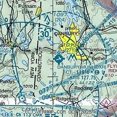
| Sectional chart |
|---|
|
CAUTION: Diagram may not be current
 Download PDF
of official airport diagram from the FAA
| Airport distance calculator |
|---|
|
|
| Sunrise and sunset |
|---|
|
Times for 05-Jul-2026
| | Local
(UTC-4) | | Zulu
(UTC) |
|---|
| Morning civil twilight | | 04:54 | | 08:54 |
| Sunrise | | 05:27 | | 09:27 |
| Sunset | | 20:29 | | 00:29 |
| Evening civil twilight | | 21:03 | | 01:03 |
|
| Current date and time |
|---|
| Zulu (UTC) | 06-Jul-2026 01:45:08 |
|---|
| Local (UTC-4) | 05-Jul-2026 21:45:08 |
|---|
|
| METAR |
|---|
| KDXR | 060053Z 13006KT 10SM BKN100 22/17 A3002 RMK AO2 SLP162 T02220167 PNO $
|
KOXC
17nm E | 060056Z 14006KT 10SM FEW100 22/17 A3004 RMK AO2 SLP181 T02170172 $
|
KBDR
20nm SE | 060052Z 07007KT 9SM FEW100 SCT120 23/20 A3001 RMK AO2 SLP162 T02280200 $
|
|
| TAF |
|---|
KBDR
20nm SE | 051948Z 0520/0618 08009KT P6SM SCT035 SCT060 FM060000 08007KT 4SM -SHRA SCT015 BKN030 FM060300 07008KT 4SM -SHRA BR OVC008 FM060600 07010KT 2SM RA BR OVC006 FM061400 06013G19KT 2SM RA BR OVC007
|
KHPN
21nm SW | 051948Z 0520/0618 11005KT P6SM -SHRA BKN020 PROB30 0522/0524 4SM TSRA BR OVC020CB FM060000 11004KT 4SM -SHRA BR BKN015 PROB30 0600/0601 2SM TSRA BKN015CB FM060100 11004KT 4SM -SHRA BR OVC007 PROB30 0601/0604 2SM TSRA OVC006CB FM060600 09005KT 2SM RA BR OVC004 FM061400 06010KT 2SM RA BR OVC005 AMD NOT SKED
|
KPOU
24nm NW | 060027Z 0600/0624 10006KT 6SM -SHRA VCTS BKN035 OVC060CB TEMPO 0600/0602 VRB15G25KT 1 1/2SM +TSRA BR BKN020 OVC040CB FM060400 09004KT 4SM -SHRA BR BKN012 OVC040 TEMPO 0604/0608 1 1/2SM +SHRA BR BKN008 OVC012 FM061400 05009KT 6SM -SHRA BR SCT015 OVC040 PROB30 0618/0624 1 1/2SM +SHRA BR BKN008 OVC012
|
|
| NOTAMs |
|---|
NOTAMs are issued by the DoD/FAA and will open in a separate window not controlled by AirNav.
|
|


