FAA INFORMATION EFFECTIVE 09 JULY 2026
Location
| FAA Identifier: | EMV |
| Lat/Long: | 36-41-12.6890N 077-28-57.8960W
36-41.211483N 077-28.964933W
36.6868581,-77.4827489
(estimated) |
| Elevation: | 126.7 ft. / 38.6 m (surveyed) |
| Variation: | 10W (2000) |
| From city: | 3 miles E of EMPORIA, VA |
| Time zone: | UTC -4 (UTC -5 during Standard Time) |
| Zip code: | 23847 |
Airport Operations
| Airport use: | Open to the public |
| Activation date: | 10/1943 |
| Control tower: | no |
| ARTCC: | WASHINGTON CENTER |
| FSS: | LEESBURG FLIGHT SERVICE STATION |
| NOTAMs facility: | EMV (NOTAM-D service available) |
| Attendance: | 0900-1700 |
| Pattern altitude: | TPA LGT ACFT 1000 FT, HVY ACFT 1500 FT. |
| Wind indicator: | lighted |
| Segmented circle: | yes |
| Lights: | ACTIVATE REIL RWY 16 & 34; MIRL RWY 16/34 - CTAF. PAPI RWY 16 & 34 OPR CONSLY. |
| Beacon: | white-green (lighted land airport)
Operates sunset to sunrise. |
Airport Communications
| CTAF/UNICOM: | 123.0 |
| WX AWOS-3: | 124.175 (434-634-0656) |
| WX AWOS-3 at LVL (16 nm W): | 119.625 (434-848-2017) |
- COMMUNICATIONS THRU WASHINGTON FSS ON FREQ 122.4.
- APCH/DEP SVC PRVDD BY WASHINGTON ARTCC ON FREQS 132.025/290.425 (LAWRENCEVILLE RCAG).
Nearby radio navigation aids
| NDB name | | Hdg/Dist | | Freq | | Var | | ID |
|---|
| WAKEFIELD | | 243/29.2 | | 274 | | 11W | | AKQ | .- -.- --.- |
| BLACKSTONE | | 143/37.8 | | 326 | | 09W | | BKT | -... -.- - |
Airport Services
| Fuel available: | 100LL JET-A |
| Parking: | hangars and tiedowns |
| Bottled oxygen: | NONE |
| Bulk oxygen: | NONE |
Runway Information
Runway 16/34
| Dimensions: | 5010 x 100 ft. / 1527 x 30 m |
| Surface: | asphalt/grooved, in good condition |
| Weight bearing capacity: | | Single wheel: | 30.0 | | Double wheel: | 50.0 | | Double tandem: | 85.0 |
|
| Runway edge lights: | medium intensity |
| RUNWAY 16 | | RUNWAY 34 |
| Latitude: | 36-41.551228N | | 36-40.871742N |
| Longitude: | 077-29.256010W | | 077-28.673888W |
| Elevation: | 126.6 ft. | | 109.9 ft. |
| Traffic pattern: | left | | left |
| Runway heading: | 155 magnetic, 145 true | | 335 magnetic, 325 true |
| Markings: | nonprecision, in good condition | | nonprecision, in good condition |
| Visual slope indicator: | 2-light PAPI on left (3.00 degrees glide path)
RWY 16 PAPI UNUSBL BYD 7 DEG LEFT & RIGHT OF CNTRLN. | | 2-light PAPI on left (3.00 degrees glide path)
RWY 34 PAPI UNUSBL BYD 8 DEG RIGHT OF CNTRLN. |
| Runway end identifier lights: | yes | | yes |
| Touchdown point: | yes, no lights | | yes, no lights |
| Instrument approach: | | | LOC/DME |
| Obstructions: | 15 ft. road, lighted, 336 ft. from runway, 263 ft. right of centerline, 9:1 slope to clear | | 34 ft. tree, lighted, 699 ft. from runway, 281 ft. left of centerline, 14:1 slope to clear |
Airport Ownership and Management from official FAA records
| Ownership: | Publicly-owned |
| Owner: | EMPORIA-GREENSVILLE ARPT COMM
139 AIRPORT DR
EMPORIA, VA 23847
Phone 804-370-2203 |
| Manager: | BARBARA MOORE
139 AIRPORT DR.
EMPORIA, VA 23847
Phone 434-634-3696 |
Additional Remarks
| - | DEER ON & INVOF ARPT. |
| - | FOR CD CTC WASHINGTON ARTCC AT 703-771-3587. |
Instrument Procedures
NOTE: All procedures below are presented as PDF files. If you need a reader for these files, you should download the free Adobe Reader.NOT FOR NAVIGATION. Please procure official charts for flight.
FAA instrument procedures published for use from 09 July 2026 at 0901Z to 06 August 2026 at 0900Z.
IAPs - Instrument Approach Procedures |
|---|
| RNAV (GPS) RWY 16 | |
download (165KB) |
| RNAV (GPS) RWY 34 | |
download (193KB) |
| LOC RWY 34 | |
download (196KB) |
| NOTE: Special Alternate Minimums apply | |
download (168KB) |
| NOTE: Special Take-Off Minimums/Departure Procedures apply | |
download (189KB) |
Other nearby airports with instrument procedures:
KLVL - Brunswick County Airport (16 nm W)
KIXA - Halifax/Northampton Regional Airport (23 nm S)
KAVC - Mecklenburg-Brunswick Regional Airport (28 nm W)
KASJ - Tri-County Airport at Henry Joyner Field (28 nm SE)
KFKN - Franklin Regional Airport (28 nm E)
|
|

Road maps at:
MapQuest
Bing
Google
| Aerial photo |
|---|
WARNING: Photo may not be current or correct
 Photo taken 05-Nov-2006
from a Mooney at 6,000 feet MSL
Photo taken 05-Nov-2006
from a Mooney at 6,000 feet MSL
Do you have a better or more recent aerial photo of Emporia-Greensville Regional Airport that you would like to share? If so, please send us your photo.
|
| Sectional chart |
|---|
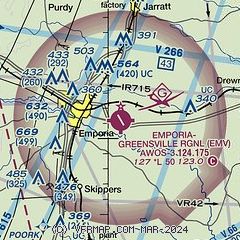
|
| Airport distance calculator |
|---|
|
|
| Sunrise and sunset |
|---|
|
Times for 29-Jul-2026
| | Local
(UTC-4) | | Zulu
(UTC) |
|---|
| Morning civil twilight | | 05:46 | | 09:46 |
| Sunrise | | 06:14 | | 10:14 |
| Sunset | | 20:18 | | 00:18 |
| Evening civil twilight | | 20:47 | | 00:47 |
|
| Current date and time |
|---|
| Zulu (UTC) | 29-Jul-2026 12:33:26 |
|---|
| Local (UTC-4) | 29-Jul-2026 08:33:26 |
|---|
|
| METAR |
|---|
| KEMV | 291215Z AUTO 30004KT 10SM 23/20 A2969 RMK AO2 T02250204
|
KLVL
16nm W | 291215Z AUTO 00000KT 10SM CLR 25/21 A2970 RMK AO1 T02490206
|
|
| TAF |
|---|
KFAF
49nm NE | 291000Z 2910/3016 32010G15KT 9999 FEW250 QNH2957INS BECMG 2917/2918 32010KT 9999 FEW050 QNH2962INS BECMG 3004/3005 30009KT 9999 FEW050 QNH2974INS TX30/2919Z TN23/2910Z
|
|
| NOTAMs |
|---|
NOTAMs are issued by the DoD/FAA and will open in a separate window not controlled by AirNav.
|
|


