FAA INFORMATION EFFECTIVE 16 APRIL 2026
Location
| FAA Identifier: | GBR |
| Lat/Long: | 42-11-03.1710N 073-24-11.6660W
42-11.052850N 073-24.194433W
42.1842142,-73.4032406
(estimated) |
| Elevation: | 739.4 ft. / 225.4 m (surveyed) |
| Variation: | 14W (1995) |
| From city: | 2 miles W of GREAT BARRINGTON, MA |
| Time zone: | UTC -4 (UTC -5 during Standard Time) |
| Zip code: | 01230 |
Airport Operations
| Airport use: | Open to the public |
| Activation date: | 04/1942 |
| Control tower: | no |
| ARTCC: | BOSTON CENTER |
| FSS: | BURLINGTON FLIGHT SERVICE STATION |
| NOTAMs facility: | BTV (NOTAM-D service available) |
| Attendance: | 0800-1700 |
| Wind indicator: | lighted |
| Segmented circle: | no |
| Lights: | ACTVT REIL RWY 11; LIRL RWY 11/29 - 121.6. |
| Beacon: | white-green (lighted land airport)
Operates sunset to sunrise. |
| Landing fee: | yes, AVCARD NOT ACPTD. |
Airport Communications
| CTAF/UNICOM: | 122.8 |
| ALBANY APPROACH: | 132.825 |
| ALBANY DEPARTURE: | 132.825 |
| WX AWOS-3 at 1B1 (15 nm NW): | 133.525 (518-828-2577) |
| WX ASOS at PSF (15 nm N): | 135.375 (413-499-3273) |
Nearby radio navigation aids
| VOR radial/distance | | VOR name | | Freq | | Var |
|---|
| CTRr265/21.2 | | CHESTER VOR/DME | | 115.10 | | 13W |
| PWLr031/26.4 | | PAWLING VOR/DME | | 114.30 | | 12W |
| BAFr287/30.6 | | BARNES VORTAC | | 113.00 | | 14W |
| IGNr043/36.3 | | KINGSTON VOR/DME | | 117.60 | | 12W |
| ALBr165/38.1 | | ALBANY VORTAC | | 115.30 | | 13W |
Airport Services
| Fuel available: | 100LL |
| Parking: | hangars and tiedowns |
| Airframe service: | MAJOR |
| Powerplant service: | MAJOR |
| Bottled oxygen: | HIGH |
| Bulk oxygen: | NONE |
Runway Information
Runway 11/29
| Dimensions: | 2579 x 50 ft. / 786 x 15 m |
| Surface: | asphalt, in fair condition |
| Weight bearing capacity: | |
| Runway edge lights: | low intensity |
| RUNWAY 11 | | RUNWAY 29 |
| Latitude: | 42-11.076800N | | 42-11.028883N |
| Longitude: | 073-24.478067W | | 073-23.910783W |
| Elevation: | 739.4 ft. | | 733.6 ft. |
| Traffic pattern: | left | | left |
| Runway heading: | 110 magnetic, 096 true | | 290 magnetic, 276 true |
| Displaced threshold: | 170 ft.
LGTD THR RELCTD 170 FT; 2409 FT OF RWY USBL FOR NGT OPS. | | 75 ft. |
| Markings: | basic, in good condition | | basic, in good condition |
| Runway end identifier lights: | yes | | no |
| Touchdown point: | yes, no lights | | yes, no lights |
| Obstructions: | 30 ft. trees, 425 ft. from runway, 130 ft. right of centerline, 7:1 slope to clear | | 57 ft. trees, 1000 ft. from runway, 210 ft. right of centerline, 14:1 slope to clear
+15 FT ROAD IN PRIM SFC AREA. |
Airport Ownership and Management from official FAA records
| Ownership: | Privately-owned |
| Owner: | BERKSHIRE AVIATION ENTERPRISES LLC
70 EGREMONT PLAIN RD., 70 EGREMONT PLAIN RD.
GREAT BARRINGTON, MA 01230
Phone 413-528-1010 |
| Manager: | JOSEPH SOLAN
70 EGREMONT PLAIN RD., 70 EGREMONT PLAIN RD.
GREAT BARRINGTON, MA 01230
Phone 413-528-1010 |
Additional Remarks
| - | TGLS NA. |
| - | PRACTICE VFR GPS RWY 11 NA WHEN RWY 29 IS IN USE FOR STUDENT TFC. |
| - | FOR CD CTC ALBANY APCH AT 518-862-2299. |
| - | WILDLIFE ON & INVOF ARPT. |
| - | COLD TEMPERATURE AIRPORT. ALTITUDE CORRECTION REQUIRED AT OR BELOW -19C. |
| - | COMPASS ROSE ADZY ONLY, NOT CRTFYD. |
Instrument Procedures
NOTE: All procedures below are presented as PDF files. If you need a reader for these files, you should download the free Adobe Reader.NOT FOR NAVIGATION. Please procure official charts for flight.
FAA instrument procedures published for use from 16 April 2026 at 0901Z to 14 May 2026 at 0900Z.
IAPs - Instrument Approach Procedures |
|---|
| RNAV (GPS) RWY 11 | |
download (199KB) |
| RNAV (GPS)-B | |
download (171KB) |
| NOTE: Special Take-Off Minimums/Departure Procedures apply | |
download (531KB) |
Other nearby airports with instrument procedures:
1B1 - Columbia County Airport (15 nm NW)
KPSF - Pittsfield Municipal Airport (15 nm N)
20N - Kingston-Ulster Airport (28 nm SW)
4B0 - South Albany Airport (30 nm NW)
KBAF - Westfield-Barnes Regional Airport (31 nm E)
|
|

Road maps at:
MapQuest
Bing
Google
| Aerial photo |
|---|
WARNING: Photo may not be current or correct
 Photo by Noah Meyerowitz
Photo taken 23-Sep-2012
looking west.
Photo by Noah Meyerowitz
Photo taken 23-Sep-2012
looking west.
Do you have a better or more recent aerial photo of Great Barrington Airport that you would like to share? If so, please send us your photo.
|
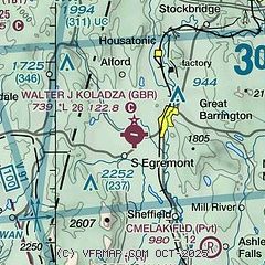
| Sectional chart |
|---|
|
| Airport distance calculator |
|---|
|
|
| Sunrise and sunset |
|---|
|
Times for 10-May-2026
| | Local
(UTC-4) | | Zulu
(UTC) |
|---|
| Morning civil twilight | | 05:07 | | 09:07 |
| Sunrise | | 05:39 | | 09:39 |
| Sunset | | 20:01 | | 00:01 |
| Evening civil twilight | | 20:33 | | 00:33 |
|
| Current date and time |
|---|
| Zulu (UTC) | 11-May-2026 00:12:19 |
|---|
| Local (UTC-4) | 10-May-2026 20:12:19 |
|---|
|
| METAR |
|---|
KPSF
16nm N | 102354Z AUTO 30007KT 10SM CLR 13/03 A2995 RMK AO2 SLP131 60000 T01330028 10183 20133 53020
|
KBAF
31nm E | 102353Z 30004KT 10SM OVC090 17/09 A2993 RMK AO2 SLP136 60000 T01720089 10217 20172 53020
|
|
| TAF |
|---|
KPSF
16nm N | 101950Z 1020/1118 31011KT P6SM SCT040 BKN070 TEMPO 1020/1021 4SM -SHRA BR BKN035 OVC060 FM102100 25010G22KT P6SM SCT040 FM110000 VRB04KT P6SM SCT100 FM110700 00000KT P6SM SCT200
|
|
| NOTAMs |
|---|
NOTAMs are issued by the DoD/FAA and will open in a separate window not controlled by AirNav.
|
|

