FAA INFORMATION EFFECTIVE 27 NOVEMBER 2025
Location
| FAA Identifier: | HMP |
| Lat/Long: | 33-23-23.6490N 084-19-51.7330W
33-23.394150N 084-19.862217W
33.3899025,-84.3310369
(estimated) |
| Elevation: | 881.9 ft. / 268.8 m (surveyed) |
| Variation: | 06W (2025) |
| From city: | 25 miles S of ATLANTA, GA |
| Time zone: | UTC -5 (UTC -4 during Daylight Saving Time) |
| Zip code: | 30228 |
Airport Operations
| Airport use: | Open to the public |
| Activation date: | 06/1970 |
| Control tower: | no |
| ARTCC: | ATLANTA CENTER |
| FSS: | MACON FLIGHT SERVICE STATION |
| NOTAMs facility: | MCN (NOTAM-D service available) |
| Attendance: | MON-FRI 0800-1700 |
| Wind indicator: | lighted |
| Segmented circle: | yes |
| Lights: | ACTVT REIL RWY 06 & 24; PAPI RWY 06 & 24; MIRL RWY 06/24 - CTAF. |
| Beacon: | white-green (lighted land airport)
Operates sunset to sunrise. |
| Landing fee: | no, ACFT PRKG FEE RQRD ON MAJOR RACE DAYS. |
Airport Communications
| CTAF/UNICOM: | 122.725 |
| WX AWOS-3: | 124.825 (770-707-1719) |
| ATLANTA APPROACH: | 128.575 |
| ATLANTA DEPARTURE: | 128.575 |
| CLEARANCE DELIVERY: | 128.575 |
| WX AWOS-3 at 6A2 (10 nm S): | 119.750 (770-227-3934) |
| WX ASOS at FFC (12 nm W): | 118.525 (770-487-1610) |
| WX ASOS at ATL (16 nm N): | PHONE 404-559-5166 |
Nearby radio navigation aids
| NDB name | | Hdg/Dist | | Freq | | Var | | ID |
|---|
| PECAT | | 061/9.4 | | 316 | | 05W | | FFC | ..-. ..-. -.-. |
| COWETA COUNTY | | 070/20.8 | | 234 | | 03W | | EQQ | . --.- --.- |
Airport Services
| Fuel available: | 100LL JET-A+
100LL:FUEL 24 HR SELF-SERVE WITH CREDIT CARD. FUEL CALL OUT AVBL. |
| Parking: | tiedowns |
| Airframe service: | MAJOR |
| Powerplant service: | MAJOR |
| Bottled oxygen: | NONE |
| Bulk oxygen: | NONE |
Runway Information
Runway 6/24
| Dimensions: | 5509 x 100 ft. / 1679 x 30 m |
| Surface: | asphalt/grooved, in good condition |
| Weight bearing capacity: | | Single wheel: | 91.0 | | Double wheel: | 118.0 |
|
| Runway edge lights: | medium intensity |
| RUNWAY 6 | | RUNWAY 24 |
| Latitude: | 33-23.130073N | | 33-23.658212N |
| Longitude: | 084-20.302628W | | 084-19.421753W |
| Elevation: | 852.0 ft. | | 881.9 ft. |
| Traffic pattern: | right | | left |
| Runway heading: | 060 magnetic, 054 true | | 240 magnetic, 234 true |
| Markings: | nonprecision, in good condition | | nonprecision, in good condition |
| Visual slope indicator: | 2-light PAPI on left (3.00 degrees glide path) | | 2-light PAPI on left (3.00 degrees glide path) |
| Runway end identifier lights: | yes | | yes |
| Touchdown point: | yes, no lights | | yes, no lights |
| Obstructions: | 68 ft. trees, 882 ft. from runway, 577 ft. left of centerline, 10:1 slope to clear | | 69 ft. tree, 1538 ft. from runway, 558 ft. right of centerline, 19:1 slope to clear |
Airport Ownership and Management from official FAA records
| Ownership: | Publicly-owned |
| Owner: | HENRY COUNTY
140 HENRY PARKWAY
MCCONOUGH, GA 30253
Phone 770-288-6000 |
| Manager: | BRANDON WILLIAMS
474 SPEEDWAY BLVE
HAMPTON, GA 30228
Phone (770) 288-7834
MAIN ARPT PHONE 770-288-7829. |
Additional Remarks
| A39-06/24 | PCR VALUE: 376/F/D/X/U |
| - | ACROBATIC TRNG & DMSTN AREA SW OF ARPT. |
| - | DEER ON & INVOF ARPT. |
| - | ACFT OVNGT PRKG FEE. |
| - | FOR CD CTC ATLANTA APCH AT 678-364-6131. |
Instrument Procedures
NOTE: All procedures below are presented as PDF files. If you need a reader for these files, you should download the free Adobe Reader.NOT FOR NAVIGATION. Please procure official charts for flight.
FAA instrument procedures published for use from 27 November 2025 at 0901Z to 25 December 2025 at 0900Z.
STARs - Standard Terminal Arrivals |
|---|
| BUKHD THREE (RNAV) | |
download (190KB) |
| DEHAN THREE (RNAV) | |
2 pages:
[1] [2] (325KB) |
IAPs - Instrument Approach Procedures |
|---|
| RNAV (GPS) RWY 06 | |
download (208KB) |
| RNAV (GPS) RWY 24 | |
download (214KB) |
| NOTE: Special Alternate Minimums apply | |
download (153KB) |
| NOTE: Special Take-Off Minimums/Departure Procedures apply | |
download (479KB) |
Other nearby airports with instrument procedures:
6A2 - Griffin-Spalding County Airport (10 nm S)
KFFC - Atlanta Regional Airport-Falcon Field (12 nm W)
KATL - Hartsfield/Jackson Atlanta International Airport (16 nm N)
KCCO - Newnan Coweta County Airport (22 nm W)
KFTY - Fulton County Executive Airport/Charlie Brown Field (25 nm N)
|
|

Road maps at:
MapQuest
Bing
Google
| Aerial photo |
|---|
WARNING: Photo may not be current or correct
 Photo courtesy of AirNav, LLC
Photo taken 03-Feb-2013
looking southeast.
Photo courtesy of AirNav, LLC
Photo taken 03-Feb-2013
looking southeast.
Do you have a better or more recent aerial photo of Atlanta Speedway Airport that you would like to share? If so, please send us your photo.
|
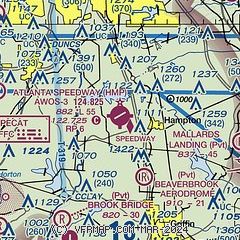
| Sectional chart |
|---|
|
| Airport distance calculator |
|---|
|
|
| Sunrise and sunset |
|---|
|
Times for 05-Dec-2025
| | Local
(UTC-5) | | Zulu
(UTC) |
|---|
| Morning civil twilight | | 07:00 | | 12:00 |
| Sunrise | | 07:28 | | 12:28 |
| Sunset | | 17:28 | | 22:28 |
| Evening civil twilight | | 17:56 | | 22:56 |
|
| Current date and time |
|---|
| Zulu (UTC) | 06-Dec-2025 03:52:22 |
|---|
| Local (UTC-5) | 05-Dec-2025 22:52:22 |
|---|
|
| METAR |
|---|
| KHMP | 060335Z AUTO 00000KT 10SM OVC008 07/06 A3002 RMK AO2 T00700062
|
KFFC
12nm W | 060329Z AUTO 30004KT 10SM OVC008 07/06 A3000 RMK AO2 T00720061
|
KATL
16nm N | 060252Z 32007KT 3SM OVC005 07/05 A3000 RMK AO2 SFC VIS 7 SLP161 CIG 00V007 T00720050 51006 $
|
|
| TAF |
|---|
KATL
16nm N | 060150Z 0602/0706 30006KT 6SM BR OVC006 FM060500 29004KT 4SM BR OVC004 FM061100 29004KT 5SM BR OVC006 FM061400 28004KT P6SM VCSH SCT006 BKN015 FM061800 27005KT P6SM OVC020 FM062100 29005KT P6SM BKN100 FM070000 VRB03KT P6SM SCT070
|
|
| NOTAMs |
|---|
NOTAMs are issued by the DoD/FAA and will open in a separate window not controlled by AirNav.
|
|


