FAA INFORMATION EFFECTIVE 14 MAY 2026
Location
| FAA Identifier: | HOP |
| Lat/Long: | 36-40-22.6416N 087-29-30.5502W
36-40.377360N 087-29.509170W
36.6729560,-87.4918195
(estimated) |
| Elevation: | 571 ft. / 174.0 m (surveyed) |
| Variation: | 01W (1995) |
| From city: | 2 miles NW of central business district of the associated city |
| Time zone: | UTC -5 (UTC -6 during Standard Time) |
| Zip code: | 42223 |
Airport Operations
| Airport use: | Private use. Permission required prior to landing |
| Control tower: | yes |
| ARTCC: | MEMPHIS CENTER |
| FSS: | LOUISVILLE FLIGHT SERVICE STATION |
| NOTAMs facility: | HOP (NOTAM-D service available) |
| Attendance: | CONTINUOUS
SEE FLIP AP/1 FLT HAZ & SUPPLEMENTARY ARPT RMK. |
| Segmented circle: | no |
| Lights: | SS-SR |
| Beacon: | white-white-green (lighted military airport)
Operates sunset to sunrise. |
| International operations: | international airport of entry
CSTMS/AG/IMG: AVBL 72 HR PPR; MIL ACFT ONLY -
D635-7146. |
Airport Communications
| CTAF: | 122.95 |
| ATIS: | 125.175 308.4 |
| CAMPBELL GROUND: | 121.8 266.8 |
| CAMPBELL TOWER: | 120.9 278.8 |
| CAMPBELL APPROACH: | 118.1 269.525 |
| CAMPBELL DEPARTURE: | 118.1 269.525 |
| CLEARANCE DELIVERY: | 138.8 |
| EMERG: | 121.5 243.0 |
| OPS: | 251.2 ;ALCE 285.7 ;EAGLE CON 65.2 ;EAGLE CON |
| PMSV METRO: | 33.2 343.3 |
| PTD: | 130.65 ;KHOP BASE OPS 142.9 ;KHOP BASE OPS 229.4 ;KHOP BASE OPS |
| WX ASOS at CKV (5 nm SE): | 134.575 (931-431-3045) |
| WX AWOS-3 at EOD (6 nm S): | PHONE 270-956-3100 |
| WX AWOS-3 at HVC (11 nm N): | 132.575 (270-886-6311) |
- EAGLE CON - OPR H24.
- CTC PRIOR TO ENTRY R3701, R3702 - 128.750 285.700.
- FULL SVC DURG FCST HR; RECEPTION POOR 200-260 DEG BYD 55 NM.
- ATCT-ARAC.
Nearby radio navigation aids
| VOR radial/distance | | VOR name | | Freq | | Var |
|---|
| CKVr310/4.9 | | CLARKSVILLE VOR/DME | | 110.60 | | 01W |
| NDB name | | Hdg/Dist | | Freq | | Var | | ID |
|---|
| AIRBE | | 225/5.4 | | 273 | | 01W | | FK | ..-. -.- |
| SNUFF | | 331/10.1 | | 335 | | 01W | | CK | -.-. -.- |
Airport Services
Runway Information
Runway 5/23
| Dimensions: | 10926 x 150 ft. / 3330 x 46 m |
| Surface: | asphalt |
| Weight bearing capacity: | |
| Runway edge lights: | high intensity |
| RUNWAY 5 | | RUNWAY 23 |
| Latitude: | 36-39.780045N | | 36-41.071367N |
| Longitude: | 087-30.178712W | | 087-28.619635W |
| Elevation: | 553.8 ft. | | 571.0 ft. |
| Traffic pattern: | left | | right |
| Markings: | precision, in good condition | | precision, in fair condition |
| Visual slope indicator: | 4-light PAPI on left (3.00 degrees glide path) | | 4-light PAPI on left (3.00 degrees glide path) |
| RVR equipment: | | | touchdown |
| Approach lights: | | | SSALR: simplified short approach lighting system with runway alignment indicator lights |
| Touchdown point: | yes, no lights | | yes, no lights |
| Instrument approach: | | | ILS/DME |
Runway 18/36
| Dimensions: | 4500 x 100 ft. / 1372 x 30 m |
| Surface: | asphalt |
| Weight bearing capacity: | |
| Runway edge lights: | high intensity |
| RUNWAY 18 | | RUNWAY 36 |
| Latitude: | 36-40.630707N | | 36-39.889250N |
| Longitude: | 087-29.782480W | | 087-29.770000W |
| Elevation: | 561.4 ft. | | 553.6 ft. |
| Traffic pattern: | left | | left |
| Markings: | nonprecision, in good condition | | basic, in poor condition |
| Visual slope indicator: | 4-light PAPI on left (3.00 degrees glide path) | | 4-light PAPI on left (3.00 degrees glide path) |
| Touchdown point: | yes, no lights | | yes, no lights |
Airport Ownership and Management from official FAA records
| Ownership: | U.S. Army |
| Owner: | US ARMY ATCA-ASO
9325 GUNSTON ROAD
FT BELVOIR, VA 22060
Phone 502-798-7146 |
| Manager: | AIRFIELD OPS
FORT CAMPBELL
Phone 270-798-7146/47 |
Additional Remarks
| - | OIL: O-123-128-148-156 SP |
| - | FLEET SVC NOT AVBL. |
| - | CTN: PJE; R3701 & SMALL ARMS RANGE 1000 YD FM DEP END RWY 23; DEER HAZ. |
| - | BASE OPS H24 - DSN 635-7146/7147/C270-798-7146/47. |
| - | JASU: 3(M-32A-86) 3(AM32-95) 1(MC-2A) |
| - | TSNT ACFT SHUT DOWN, REQ SVC OR STORM RAMP PRKG PPR. FIXED WING FREEDOM & SERPENT RAMP ACES OR PRKG NA. |
| - | WX FCST OR OBS H24 - EAGLE CON. |
| - | RSTD: TWY K NORTH OF RWY 05/23 ROTARY WING ONLY. |
| - | EAGLE RDO - CLSD FM 1200Z SAT - 1200Z MON -6(-5DT); CTC PRIOR TO ENTRY R3701, R3702 - 139.9 285.700. |
| - | BACH HEL APCH HDG 155 DEG; DEP HDG 335 DEG; CTC APCH ON 118.1; VFR ONLY. LTD USE BY AIR AMBULANCE AVOID OVFT OF HOSP, WILSON THEATER, GARRISON HQ, HOUSING AREA AND SCHOOLS. PCL VHF 122.8. |
| - | NAVAID: HXW TACAN & FK NDB UNMNT 0400-1400Z++. |
| - | FOR CD WHEN UNA VIA FREQ CTC CAMPBELL APCH AT 270-798-6441. |
| - | NO CLASSIFIED OR COMSEC STORAGE AVBL. |
| - | TWY A, C, D, E, G, H, L & M PAVED SHOULDERS NA. |
Instrument Procedures
NOTE: All procedures below are presented as PDF files. If you need a reader for these files, you should download the free Adobe Reader.NOT FOR NAVIGATION. Please procure official charts for flight.
FAA instrument procedures published for use from 14 May 2026 at 0901Z to 11 June 2026 at 0900Z.
IAPs - Instrument Approach Procedures |
|---|
| ILS OR LOC Y RWY 23 **NEW** | |
download (131KB) |
| RNAV (GPS) RWY 18 **CHANGED** | |
download (113KB) |
| RNAV (GPS) RWY 23 **CHANGED** | |
download (76KB) |
| TACAN RWY 23 **CHANGED** | |
download (116KB) |
| Radar Approach Procedures available **CHANGED** | |
download (130KB) |
Other nearby airports with instrument procedures:
KCKV - Outlaw Field Airport (5 nm SE)
KEOD - Sabre Army Airfield (Fort Campbell) (6 nm S)
KHVC - Hopkinsville-Christian County Airport (11 nm N)
M91 - Springfield Robertson County Airport (29 nm E)
2M0 - Princeton-Caldwell County Airport (32 nm NW)
|
|

Road maps at:
MapQuest
Bing
Google
| Aerial photo |
|---|
WARNING: Photo may not be current or correct

Do you have a better or more recent aerial photo of Campbell Army Airfield (Fort Campbell) that you would like to share? If so, please send us your photo.
|
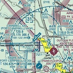
| Sectional chart |
|---|
|
 Download PDF
of official airport diagram from the FAA
| Airport distance calculator |
|---|
|
|
| Sunrise and sunset |
|---|
|
Times for 06-Jun-2026
| | Local
(UTC-5) | | Zulu
(UTC) |
|---|
| Morning civil twilight | | 05:02 | | 10:02 |
| Sunrise | | 05:32 | | 10:32 |
| Sunset | | 20:05 | | 01:05 |
| Evening civil twilight | | 20:35 | | 01:35 |
|
| Current date and time |
|---|
| Zulu (UTC) | 06-Jun-2026 18:55:48 |
|---|
| Local (UTC-5) | 06-Jun-2026 13:55:48 |
|---|
|
| METAR |
|---|
| KHOP | 061755Z AUTO 23009KT 10SM FEW170 SCT210 30/19 A3000 RMK AO2 SLP155 T02980185 10299 20211 57009
|
KCKV
5nm SE | 061752Z AUTO 10SM SCT048 BKN065 31/18 A3002 RMK AO2 SLP160 T03060183 10306 20194 56010
|
KEOD
6nm S | 061755Z AUTO 24006KT 10SM FEW240 FEW300 FEW350 30/19 A3004 RMK AO2 SLP170 T02970188 10301 20197 57009
|
KHVC
11nm N | 061835Z AUTO 20007KT 10SM -DZ FEW050 30/18 A3000 RMK AO2
|
|
| TAF |
|---|
| KHOP | 061600Z 0616/0722 22010KT 9999 BKN050 QNH3002INS BECMG 0621/0622 22010KT 9999 SCT060 BKN160 QNH2996INS BECMG 0713/0714 VRB06KT 9999 SCT025 BKN060 QNH2998INS BECMG 0715/0716 16012KT 6000 -SHRA BKN025 QNH2992INS TEMPO 0717/0722 -TSRA BKN025CB TX30/0621Z TN20/0709Z
|
KCKV
5nm SE | 061720Z 0618/0718 20009KT P6SM SKC FM070100 19003KT P6SM BKN240 FM071700 15006KT P6SM BKN018
|
|
| NOTAMs |
|---|
NOTAMs are issued by the DoD/FAA and will open in a separate window not controlled by AirNav.
|
|


