FAA INFORMATION EFFECTIVE 30 OCTOBER 2025
Location
| FAA Identifier: | HQU |
| Lat/Long: | 33-31-47.0300N 082-31-01.0300W
33-31.783833N 082-31.017167W
33.5297306,-82.5169528
(estimated) |
| Elevation: | 501.3 ft. / 152.8 m (surveyed) |
| Variation: | 04W (1995) |
| From city: | 4 miles N of THOMSON, GA |
| Time zone: | UTC -5 (UTC -4 during Daylight Saving Time) |
| Zip code: | 30824 |
Airport Operations
| Airport use: | Open to the public |
| Control tower: | no |
| ARTCC: | ATLANTA CENTER |
| FSS: | MACON FLIGHT SERVICE STATION |
| NOTAMs facility: | MCN (NOTAM-D service available) |
| Attendance: | 0800-1700 |
| Wind indicator: | lighted |
| Segmented circle: | yes |
| Lights: | ACTVT PAPI RWY 10 & 28; HIRL RWY 10/28 - CTAF. |
| Beacon: | white-green (lighted land airport)
Operates sunset to sunrise. |
Airport Communications
| CTAF/UNICOM: | 122.8 |
| WX AWOS-3: | 120.625 (706-597-9801) |
| AUGUSTA APPROACH: | 124.45 [0600-0000] |
| AUGUSTA DEPARTURE: | 124.45 [0600-0000] |
- APCH/DEP SVC PRVDD BY ATLANTA ARTCC ON FREQS 128.1/322.325 (AUGUSTA RCAG) WHEN AUGUSTA APCH CTL CLSD.
Nearby radio navigation aids
| VOR radial/distance | | VOR name | | Freq | | Var |
|---|
| IRQr243/20.7 | | COLLIERS VORTAC | | 113.90 | | 04W |
| NDB name | | Hdg/Dist | | Freq | | Var | | ID |
|---|
| CEDAR | | 097/4.9 | | 341 | | 04W | | AA | .- .- |
| EMORY | | 283/26.3 | | 385 | | 04W | | EMR | . -- .-. |
| CULVR | | 059/39.4 | | 380 | | 04W | | UMB | ..- -- -... |
Airport Services
| Fuel available: | 100LL JET-A+ |
| Parking: | hangars and tiedowns |
| Airframe service: | MINOR |
| Powerplant service: | MINOR |
| Bottled oxygen: | HIGH/LOW |
| Bulk oxygen: | HIGH/LOW |
Runway Information
Runway 10/28
| Dimensions: | 5514 x 100 ft. / 1681 x 30 m |
| Surface: | asphalt, in good condition |
| Weight bearing capacity: | | Single wheel: | 30.0 | | Double wheel: | 50.0 | | Double tandem: | 87.0 |
|
| Runway edge lights: | high intensity |
| RUNWAY 10 | | RUNWAY 28 |
| Latitude: | 33-31.804857N | | 33-31.762787N |
| Longitude: | 082-31.559298W | | 082-30.475043W |
| Elevation: | 448.5 ft. | | 501.3 ft. |
| Traffic pattern: | left | | left |
| Runway heading: | 097 magnetic, 093 true | | 277 magnetic, 273 true |
| Displaced threshold: | 299 ft. | | 194 ft. |
| Declared distances: | TORA:5514 TODA:5514 ASDA:5514 LDA:5215 | | TORA:5514 TODA:5514 ASDA:5373 LDA:5179 |
| Markings: | precision, in fair condition | | precision, in fair condition |
| Visual slope indicator: | 2-light PAPI on left (3.00 degrees glide path) | | 2-light PAPI on left (3.50 degrees glide path) |
| Touchdown point: | yes, no lights | | yes, no lights |
| Instrument approach: | ILS | | |
| Obstructions: | 103 ft. trees, 2878 ft. from runway, 57 ft. left of centerline, 26:1 slope to clear | | 83 ft. trees, 1694 ft. from runway, 212 ft. right of centerline, 18:1 slope to clear
50 FT TREES 480 FT RIGHT AT 0 FT - 200 FT FM RWY END. |
Airport Ownership and Management from official FAA records
| Ownership: | Publicly-owned |
| Owner: | THOMSON CITY & MCDUFFIE CO
P.O. BOX 1017
THOMSON, GA 30824
Phone 706-595-1781
MCDUFFIE COUNTY - 210 RAIL ROAD STREET, THOMSON, GA 30824. |
| Manager: | JOHN WALLER
CITY OF THOMSON, 210 RAILROAD STREET
THOMSON, GA 30824
Phone 706-597-7378 |
Additional Remarks
| - | DEER ON RWY AT NGT. |
| - | FOR CD CTC AUGUSTA APCH AT 706-771-1777, WHEN APCH CLSD CTC ATLANTA ARTCC AT 770-210-7692. |
| - | RCO RELAY FREQ 124.45 AVAIL FOR GND USE. |
Instrument Procedures
NOTE: All procedures below are presented as PDF files. If you need a reader for these files, you should download the free Adobe Reader.NOT FOR NAVIGATION. Please procure official charts for flight.
FAA instrument procedures published for use from 30 October 2025 at 0901Z to 27 November 2025 at 0900Z.
IAPs - Instrument Approach Procedures |
|---|
| ILS OR LOC/NDB RWY 10 | |
download (250KB) |
| RNAV (GPS) RWY 10 | |
download (265KB) |
| RNAV (GPS) RWY 28 | |
download (285KB) |
| VOR/DME-A | |
download (216KB) |
| NOTE: Special Alternate Minimums apply | |
download (159KB) |
Departure Procedures |
|---|
| AZALA FOUR (RNAV) | |
download (164KB) |
| CHATT SIX (RNAV) | |
download (167KB) |
| MISTY SIX (RNAV) | |
download (174KB) |
| NDINA FIVE (RNAV) | |
download (162KB) |
| SAMMI FOUR (RNAV) | |
download (135KB) |
| NOTE: Special Take-Off Minimums/Departure Procedures apply | |
download (517KB) |
Other nearby airports with instrument procedures:
KIIY - Washington/Wilkes County Airport (21 nm NW)
KDNL - Daniel Field Airport (24 nm E)
KAGS - Augusta Regional Airport at Bush Field (29 nm E)
KCPP - Greene County Regional Airport (31 nm W)
2J3 - Louisville Municipal Airport (33 nm S)
|
|

Road maps at:
MapQuest
Bing
Google
| Aerial photo |
|---|
WARNING: Photo may not be current or correct
 Photo courtesy of AirNav, LLC
Photo taken 15-Jan-2010
Photo courtesy of AirNav, LLC
Photo taken 15-Jan-2010
Do you have a better or more recent aerial photo of Thomson/McDuffie County Airport that you would like to share? If so, please send us your photo.
|
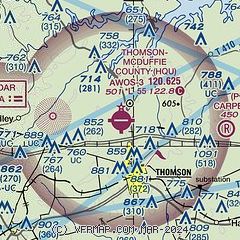
| Sectional chart |
|---|
|
CAUTION: Diagram may not be current

| Airport distance calculator |
|---|
|
|
| Sunrise and sunset |
|---|
|
Times for 09-Nov-2025
| | Local
(UTC-5) | | Zulu
(UTC) |
|---|
| Morning civil twilight | | 06:31 | | 11:31 |
| Sunrise | | 06:57 | | 11:57 |
| Sunset | | 17:31 | | 22:31 |
| Evening civil twilight | | 17:57 | | 22:57 |
|
| Current date and time |
|---|
| Zulu (UTC) | 09-Nov-2025 12:33:45 |
|---|
| Local (UTC-5) | 09-Nov-2025 07:33:45 |
|---|
|
| METAR |
|---|
| KHQU | 091215Z AUTO 00000KT 5SM BR BKN013 17/17 A2993 RMK AO2
|
|
| TAF |
|---|
KDNL
24nm E | 091120Z 0912/1012 VRB03KT P6SM OVC007 TEMPO 0912/0914 SCT007 BKN015 FM091400 25012G20KT P6SM FEW015 SCT250 FM100100 30010G18KT P6SM SCT100
|
KAGS
29nm E | 091120Z 0912/1012 VRB03KT P6SM OVC007 TEMPO 0912/0914 3SM BR SCT007 OVC015 FM091400 25012G22KT P6SM SCT015 BKN045 FM100100 30010G18KT P6SM SCT100
|
|
| NOTAMs |
|---|
NOTAMs are issued by the DoD/FAA and will open in a separate window not controlled by AirNav.
|
|


