FAA INFORMATION EFFECTIVE 11 JUNE 2026
Location
| FAA Identifier: | HSI |
| Lat/Long: | 40-36-18.9000N 098-25-40.4000W
40-36.315000N 098-25.673333W
40.6052500,-98.4278889
(estimated) |
| Elevation: | 1961.2 ft. / 597.8 m (surveyed) |
| Variation: | 07E (1995) |
| From city: | 2 miles NW of HASTINGS, NE |
| Time zone: | UTC -5 (UTC -6 during Standard Time) |
| Zip code: | 68901 |
Airport Operations
| Airport use: | Open to the public |
| Activation date: | 04/1940 |
| Control tower: | no |
| ARTCC: | MINNEAPOLIS CENTER |
| FSS: | COLUMBUS FLIGHT SERVICE STATION |
| NOTAMs facility: | HSI (NOTAM-D service available) |
| Attendance: | MON-FRI 0800-1700 |
| Wind indicator: | lighted |
| Segmented circle: | yes |
| Lights: | ACTVT MIRL RYS 04/22 & 14/32 AND PAPI RYS 04/22 & 14/32 AND REIL RYS 14 & 32 - CTAF. |
| Beacon: | white-green (lighted land airport)
Operates sunset to sunrise. |
Airport Communications
| CTAF/UNICOM: | 122.8 |
| WX ASOS: | 120.525 (402-463-4029) |
- APCH/DEP SVC PRVDD BY MINNEAPOLIS ARTCC ON FREQS 119.4/278.8 (HASTINGS RCAG).
Nearby radio navigation aids
| VOR radial/distance | | VOR name | | Freq | | Var |
|---|
| GRIr186/23.3 | | GRAND ISLAND VOR/DME | | 116.55 | | 07E |
| EARr100/(27.2) | | KEARNEY VOR | | 111.20 | | 05E |
| NDB name | | Hdg/Dist | | Freq | | Var | | ID |
|---|
| BEKLOF | | 268/39.2 | | 392 | | 03E | | FMZ | ..-. -- --.. |
Airport Services
| Fuel available: | 100LL JET-A
A:FUEL INJECTION ADDITIVES AVBL.
100LL:SELF-SVC FUEL AVBL 24 HRS. |
| Parking: | hangars and tiedowns |
| Airframe service: | MAJOR |
| Powerplant service: | MAJOR |
| Bottled oxygen: | NONE |
| Bulk oxygen: | NONE |
Runway Information
Runway 14/32
| Dimensions: | 6451 x 100 ft. / 1966 x 30 m |
| Surface: | concrete, in good condition |
| Weight bearing capacity: | | Single wheel: | 36.0 | | Double wheel: | 58.0 | | Double tandem: | 106.0 |
|
| Runway edge lights: | medium intensity |
| RUNWAY 14 | | RUNWAY 32 |
| Latitude: | 40-36.862687N | | 40-35.939863N |
| Longitude: | 098-26.019153W | | 098-25.328597W |
| Elevation: | 1961.2 ft. | | 1938.0 ft. |
| Traffic pattern: | left | | left |
| Runway heading: | 143 magnetic, 150 true | | 323 magnetic, 330 true |
| Displaced threshold: | no | | 950 ft. |
| Declared distances: | TORA:5500 TODA:6451 ASDA:5500 LDA:5500 | | TORA:6451 TODA:6451 ASDA:6451 LDA:5500 |
| Markings: | nonprecision, in good condition | | nonprecision, in good condition |
| Visual slope indicator: | 4-light PAPI on left (3.00 degrees glide path) | | 4-light PAPI on right (3.00 degrees glide path) |
| Runway end identifier lights: | yes | | yes |
| Touchdown point: | yes, no lights | | yes, no lights |
| Obstructions: | none
APCH RATIO 48:1 DUE TO RR TWR 35 FT ABV & 1884 FT FM RWY END; 166 L. | | 14 ft. road, 364 ft. from runway, 275 ft. right of centerline, 11:1 slope to clear
APCH RATIO FM DSPLCD THR 50:1. |
Runway 4/22
| Dimensions: | 4501 x 75 ft. / 1372 x 23 m |
| Surface: | concrete, in good condition |
| Weight bearing capacity: | | Single wheel: | 36.0 | | Double wheel: | 47.0 |
|
| Runway edge lights: | medium intensity |
| RUNWAY 4 | | RUNWAY 22 |
| Latitude: | 40-35.936520N | | 40-36.444535N |
| Longitude: | 098-26.027350W | | 098-25.319268W |
| Elevation: | 1939.4 ft. | | 1947.5 ft. |
| Traffic pattern: | left | | left |
| Runway heading: | 040 magnetic, 047 true | | 220 magnetic, 227 true |
| Markings: | nonprecision, in good condition | | basic, in good condition |
| Visual slope indicator: | 2-light PAPI on left (3.00 degrees glide path) | | 2-light PAPI on left (3.00 degrees glide path) |
| Touchdown point: | yes, no lights | | yes, no lights |
Airport Ownership and Management from official FAA records
| Ownership: | Publicly-owned |
| Owner: | CITY OF HASTINGS
220 N. HASTINGS AVENUE
HASTINGS, NE 68901-5144
Phone 402-984-5223 |
| Manager: | MATTHEW KUHR
220 N. HASTINGS AVENUE
HASTINGS, NE 68901-5144
Phone 402-984-5223
ARPT CELL- MON-FRI 0800-1700 (402) 705-2420. |
Additional Remarks
| A57-22 | APCH RATIO 50:1 TO RWY THR. |
| A57-04 | APCH RATIO 50:1 TO RWY THR. |
| - | FOR CD CTC MINNEAPOLIS ARTCC AT 651-463-5588. |
Instrument Procedures
NOTE: All procedures below are presented as PDF files. If you need a reader for these files, you should download the free Adobe Reader.NOT FOR NAVIGATION. Please procure official charts for flight.
FAA instrument procedures published for use from 11 June 2026 at 0901Z to 09 July 2026 at 0900z.
IAPs - Instrument Approach Procedures |
|---|
| RNAV (GPS) RWY 04 | |
download (242KB) |
| RNAV (GPS) RWY 14 | |
download (232KB) |
| RNAV (GPS) RWY 32 | |
download (212KB) |
| NOTE: Special Alternate Minimums apply | |
download (147KB) |
| NOTE: Special Take-Off Minimums/Departure Procedures apply | |
download (147KB) |
Other nearby airports with instrument procedures:
08K - Harvard State Airport (16 nm E)
KGRI - Central Nebraska Regional Airport (22 nm N)
0V3 - Pioneer Village Field Airport (24 nm W)
KAUH - Aurora Municipal Airport/Al Potter Field (26 nm NE)
KEAR - Kearney Regional Airport (27 nm W)
|
|

Road maps at:
MapQuest
Bing
Google
| Aerial photo |
|---|
WARNING: Photo may not be current or correct

Do you have a better or more recent aerial photo of Hastings Municipal Airport that you would like to share? If so, please send us your photo.
|
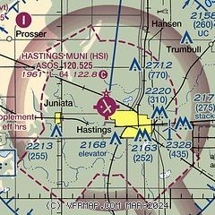
| Sectional chart |
|---|
|
CAUTION: Diagram may not be current

| Airport distance calculator |
|---|
|
|
| Sunrise and sunset |
|---|
|
Times for 17-Jun-2026
| | Local
(UTC-5) | | Zulu
(UTC) |
|---|
| Morning civil twilight | | 05:30 | | 10:30 |
| Sunrise | | 06:03 | | 11:03 |
| Sunset | | 21:06 | | 02:06 |
| Evening civil twilight | | 21:39 | | 02:39 |
|
| Current date and time |
|---|
| Zulu (UTC) | 17-Jun-2026 16:53:35 |
|---|
| Local (UTC-5) | 17-Jun-2026 11:53:35 |
|---|
|
| METAR |
|---|
| KHSI | 171553Z AUTO 01016G21KT 10SM CLR 26/15 A2952 RMK AO2 SLP979 T02610150
|
|
| TAF |
|---|
KGRI
22nm N | 171355Z 1714/1812 33017G23KT P6SM SKC FM171700 32024G34KT P6SM SKC FM180200 34008KT P6SM FEW150 FM180500 33005KT P6SM BKN100
|
KEAR
27nm W | 171133Z 1712/1812 24016KT P6SM SKC FM171300 33015G22KT P6SM SKC FM171800 32024G32KT P6SM SKC FM180200 34008KT P6SM FEW150 FM180500 33005KT P6SM BKN100
|
|
| NOTAMs |
|---|
NOTAMs are issued by the DoD/FAA and will open in a separate window not controlled by AirNav.
|
|


