FAA INFORMATION EFFECTIVE 14 MAY 2026
Location
| FAA Identifier: | MGY |
| Lat/Long: | 39-35-20.3000N 084-13-29.5000W
39-35.338333N 084-13.491667W
39.5889722,-84.2248611
(estimated) |
| Elevation: | 956.6 ft. / 291.6 m (surveyed) |
| Variation: | 04W (1995) |
| From city: | 10 miles S of DAYTON, OH |
| Time zone: | UTC -4 (UTC -5 during Standard Time) |
| Zip code: | 45342 |
Airport Operations
| Airport use: | Open to the public |
| Activation date: | 12/1957 |
| Control tower: | no |
| ARTCC: | INDIANAPOLIS CENTER |
| FSS: | DAYTON FLIGHT SERVICE STATION |
| NOTAMs facility: | MGY (NOTAM-D service available) |
| Attendance: | 0700-2000 |
| Wind indicator: | lighted |
| Segmented circle: | no |
| Lights: | ACTVT MALS RWY 20; PAPI RWY 02 & 20; MIRL RWY 02/20 - CTAF. TWY LGTS OPR CONSLY SS-SR. |
| Beacon: | white-green (lighted land airport)
Operates sunset to sunrise. |
Airport Communications
| CTAF/UNICOM: | 122.8 |
| WX ASOS: | 118.375 (937-885-2171) |
| COLUMBUS APPROACH: | 118.85 |
| COLUMBUS DEPARTURE: | 118.85 |
| CLEARANCE DELIVERY: | 119.4 |
| DANEI STAR: | 134.45 |
| WX AWOS-3PT at I68 (8 nm S): | 120.55 (513-934-5500) |
| WX AWOS-3PT at MWO (9 nm SW): | 120.025 (513-422-3505) |
| WX AWOS-3 at GDK (12 nm NE): | 118.525 (937-372-4668) |
| WX AWOS-3 at I66 (18 nm E): | 124.175 (937-382-1376) |
| WX ASOS at DAY (19 nm N): | PHONE 937-419-1421 |
| WX ASOS at HAO (19 nm SW): | 121.425 (513-863-6137) |
Nearby radio navigation aids
| VOR radial/distance | | VOR name | | Freq | | Var |
|---|
| MXQr300/21.8 | | MIDWEST VOR/DME | | 112.90 | | 04W |
| DQNr164/26.8 | | DAYTON VOR/DME | | 114.50 | | 01W |
| NDB name | | Hdg/Dist | | Freq | | Var | | ID |
|---|
| ONIDA | | 086/4.6 | | 223 | | 04W | | MW | -- .-- |
| SPORTYS | | 003/30.7 | | 245 | | 04W | | PWF | .--. .-- ..-. |
| COURT HOUSE | | 275/38.5 | | 414 | | 06W | | CSS | -.-. ... ... |
Airport Services
| Fuel available: | 100LL JET-A JET-A+ |
| Parking: | hangars and tiedowns |
| Airframe service: | MAJOR |
| Powerplant service: | MAJOR |
| Bottled oxygen: | HIGH/LOW |
| Bulk oxygen: | NONE |
Runway Information
Runway 2/20
| Dimensions: | 5000 x 100 ft. / 1524 x 30 m |
| Surface: | asphalt/grooved, in good condition |
| Weight bearing capacity: | | Single wheel: | 50.0 | | Double wheel: | 60.0 |
|
| Runway edge lights: | medium intensity |
| RUNWAY 2 | | RUNWAY 20 |
| Latitude: | 39-34.956500N | | 39-35.718747N |
| Longitude: | 084-13.692647W | | 084-13.289923W |
| Elevation: | 936.2 ft. | | 956.6 ft. |
| Traffic pattern: | left | | left |
| Runway heading: | 026 magnetic, 022 true | | 206 magnetic, 202 true |
| Displaced threshold: | no | | 590 ft. |
| Declared distances: | TORA:5000 TODA:5000 ASDA:4700 LDA:4700 | | TORA:5000 TODA:5000 ASDA:5000 LDA:4410 |
| Markings: | nonprecision, in fair condition | | nonprecision, in fair condition |
| Visual slope indicator: | 2-light PAPI on left (3.00 degrees glide path) | | 4-light PAPI on left (3.00 degrees glide path)
PAPI UNUSBL BYD 7 DEGS RIGHT OF CNTRLN. |
| Approach lights: | | | MALS: 1,400 foot medium intensity approach lighting system |
| Runway end identifier lights: | no | | |
| Touchdown point: | yes, no lights | | yes, no lights |
| Instrument approach: | | | LOC/DME |
| Obstructions: | none | | 25 ft. road, 540 ft. from runway, 300 ft. right of centerline, 13:1 slope to clear
APCH SLP 34:1 TO DTHR. |
Airport Ownership and Management from official FAA records
| Ownership: | Publicly-owned |
| Owner: | CITY OF DAYTON
101 W 3RD ST
DAYTON, OH 45402-1859
Phone 937-333-3600 |
| Manager: | BRANDON ELLIS
3600 TERMINAL DR STE 300
VANDALIA, OH 45377-1095
Phone 937-454-7897
CELL 937-776-2194. |
Additional Remarks
| - | DEER, BIRDS, & OTR WILDLIFE ON & INVOF ARPT. |
| - | SFC CONDS UNMON 1530-0700 WKDAYS & ALL DAY WKENDS/HOLS. |
| - | FULL PWR MAINT RUNUPS PROHIBITED IN THE HLDG APN AT THE NW CORNER OF TWY A 0800-1700 WKDAYS. |
Instrument Procedures
NOTE: All procedures below are presented as PDF files. If you need a reader for these files, you should download the free Adobe Reader.NOT FOR NAVIGATION. Please procure official charts for flight.
FAA instrument procedures published for use from 14 May 2026 at 0901Z to 11 June 2026 at 0900Z.
STARs - Standard Terminal Arrivals |
|---|
| DANEI THREE | |
download (158KB) |
IAPs - Instrument Approach Procedures |
|---|
| RNAV (GPS) RWY 02 **CHANGED** | |
download (238KB) |
| RNAV (GPS) RWY 20 **CHANGED** | |
download (238KB) |
| LOC RWY 20 **CHANGED** | |
download (217KB) |
| NOTE: Special Alternate Minimums apply | |
download (167KB) |
| NOTE: Special Take-Off Minimums/Departure Procedures apply | |
download (474KB) |
Other nearby airports with instrument procedures:
I73 - Moraine Air Park (6 nm N)
I68 - Warren County Airport/John Lane Field (8 nm S)
KMWO - Middletown Regional Airport/Hook Field (9 nm SW)
KGDK - Greene County/Lewis A Jackson Regional Airport (12 nm NE)
KFFO - Wright-Patterson Air Force Base (16 nm NE)
I66 - Clinton Field Airport (18 nm E)
KDAY - James M Cox Dayton International Airport (19 nm N)
KHAO - Butler County Regional Airport/Hogan Field (19 nm SW)
|
|

Road maps at:
MapQuest
Bing
Google
| Aerial photo |
|---|
WARNING: Photo may not be current or correct
 Photo taken 25-Oct-2011
looking east.
Photo taken 25-Oct-2011
looking east.
Do you have a better or more recent aerial photo of Dayton/Wright Brothers Airport that you would like to share? If so, please send us your photo.
|
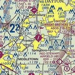
| Sectional chart |
|---|
|
| Airport distance calculator |
|---|
|
|
| Sunrise and sunset |
|---|
|
Times for 03-Jun-2026
| | Local
(UTC-4) | | Zulu
(UTC) |
|---|
| Morning civil twilight | | 05:40 | | 09:40 |
| Sunrise | | 06:12 | | 10:12 |
| Sunset | | 20:58 | | 00:58 |
| Evening civil twilight | | 21:30 | | 01:30 |
|
| Current date and time |
|---|
| Zulu (UTC) | 04-Jun-2026 03:26:19 |
|---|
| Local (UTC-4) | 03-Jun-2026 23:26:19 |
|---|
|
| METAR |
|---|
| KMGY | 040253Z AUTO 12003KT 10SM CLR 17/08 A3023 RMK AO2 SLP232 T01670078 55002
|
KI68
8nm S | 040315Z AUTO 12003KT 10SM CLR 19/09 A3023 RMK AO2
|
KMWO
9nm SW | 040315Z AUTO 32003KT 10SM CLR 14/11 A3024 RMK AO2
|
KFFO
16nm NE | 040156Z 00000KT 10SM FEW250 20/10 A3022 RMK AO2A SLP232 T01990100
|
KDAY
19nm N | 040256Z 12003KT 10SM SCT250 20/07 A3024 RMK AO2 SLP235 T02000067 55004
|
KHAO
19nm SW | 040253Z AUTO 00000KT 10SM CLR 14/12 A3024 RMK AO2 SLP237 T01440117 55001
|
|
| TAF |
|---|
KFFO
16nm NE | 031900Z 0319/0501 07009KT 9999 SCT250 QNH3021INS WND VRB06KT AFT 0323 BECMG 0415/0416 21012KT 9999 FEW250 QNH3006INS WND 20006KT AFT 0500 TX28/0419Z TN12/0410Z
|
KDAY
19nm N | 031720Z 0318/0418 07006KT P6SM FEW250 FM040100 11004KT P6SM FEW250 FM041500 21007KT P6SM FEW250
|
|
| NOTAMs |
|---|
NOTAMs are issued by the DoD/FAA and will open in a separate window not controlled by AirNav.
|
|


