FAA INFORMATION EFFECTIVE 09 JULY 2026
Location
| FAA Identifier: | OBI |
| Lat/Long: | 39-13-08.9000N 074-47-41.1000W
39-13.148333N 074-47.685000W
39.2191389,-74.7947500
(estimated) |
| Elevation: | 41 ft. / 12.5 m (surveyed) |
| Variation: | 12W (2000) |
| From city: | 2 miles SE of WOODBINE, NJ |
| Time zone: | UTC -4 (UTC -5 during Standard Time) |
| Zip code: | 08270 |
Airport Operations
| Airport use: | Open to the public |
| Activation date: | 05/1943 |
| Control tower: | no |
| ARTCC: | WASHINGTON CENTER |
| FSS: | MILLVILLE FLIGHT SERVICE STATION |
| NOTAMs facility: | MIV (NOTAM-D service available) |
| Attendance: | MON-FRI 0830-1430 |
| Wind indicator: | lighted |
| Segmented circle: | no |
| Lights: | ACTVT MIRL RWY 13/31 & 01/19 - CTAF. |
| Beacon: | white-green (lighted land airport)
Operates sunset to sunrise. |
Airport Communications
| CTAF/UNICOM: | 123.05 |
| WX AWOS-3: | 120.475 (609-861-0610) |
| ATLANTIC CITY APPROACH: | 124.6 |
| ATLANTIC CITY DEPARTURE: | 124.6 |
| WX AWOS-AV at 26N (9 nm E): | 119.775 (609-398-0705) |
| WX AWOS-3PT at WWD (14 nm SW): | 118.275 (609-886-9089) |
| WX ASOS at MIV (16 nm NW): | 119.6 (856-327-3455) |
| WX ASOS at ACY (18 nm NE): | PHONE 609-277-2644 |
Nearby radio navigation aids
| VOR radial/distance | | VOR name | | Freq | | Var |
|---|
| SIEr011/7.4 | | SEA ISLE VORTAC | | 114.80 | | 09W |
| ACYr226/17.5 | | ATLANTIC CITY VORTAC | | 117.15 | | 10W |
| VCNr167/20.7 | | CEDAR LAKE VOR/DME | | 115.20 | | 10W |
| ATRr047/31.3 | | WATERLOO VOR/DME | | 112.60 | | 09W |
| ENOr100/33.5 | | SMYRNA VORTAC | | 111.40 | | 09W |
| OODr147/34.4 | | WOODSTOWN VORTAC | | 112.80 | | 10W |
| CYNr215/39.6 | | COYLE VORTAC | | 113.40 | | 10W |
| NDB name | | Hdg/Dist | | Freq | | Var | | ID |
|---|
| RAINBOW | | 138/19.8 | | 363 | | 11W | | RNB | .-. -. -... |
Airport Services
| Fuel available: | 100LL |
| Parking: | tiedowns |
| Airframe service: | MAJOR |
| Powerplant service: | MAJOR |
| Bottled oxygen: | NONE |
| Bulk oxygen: | NONE |
Runway Information
Runway 1/19
| Dimensions: | 3304 x 75 ft. / 1007 x 23 m |
| Surface: | asphalt, in fair condition
SGFNT NR OF LONGL AND TRANSVERSE CRACKS ON RWY WITH WEEDS AND GRASS GROWING IN CRACKS. |
| Weight bearing capacity: | | Single wheel: | 45.0 | | Double wheel: | 60.0 | | Double tandem: | 120.0 |
|
| Runway edge lights: | medium intensity |
| RUNWAY 1 | | RUNWAY 19 |
| Latitude: | 39-12.844257N | | 39-13.388513N |
| Longitude: | 074-47.810472W | | 074-47.810053W |
| Elevation: | 24.5 ft. | | 41.0 ft. |
| Traffic pattern: | left | | left |
| Runway heading: | 012 magnetic, 000 true | | 192 magnetic, 180 true |
| Markings: | nonprecision, in fair condition | | nonprecision, in fair condition |
| Visual slope indicator: | | | 2-light PAPI on left (3.70 degrees glide path)
PAPI HIGH INTST ONLY. |
| Runway end identifier lights: | | | yes |
| Touchdown point: | yes, no lights | | yes, no lights |
| Obstructions: | 31 ft. trees, 316 ft. from runway, 158 ft. left of centerline, 3:1 slope to clear | | 43 ft. trees, 768 ft. from runway, 322 ft. right of centerline, 12:1 slope to clear |
Runway 13/31
| Dimensions: | 3074 x 75 ft. / 937 x 23 m |
| Surface: | asphalt, in fair condition
SGFNT NR OF LONGL AND TRANSVERSE CRACKS ON RWY WITH GRASS AND WEEDS GROWING IN CRACKS. |
| Weight bearing capacity: | | Single wheel: | 35.0 | | Double wheel: | 50.0 | | Double tandem: | 110.0 |
|
| Runway edge lights: | medium intensity |
| RUNWAY 13 | | RUNWAY 31 |
| Latitude: | 39-13.311228N | | 39-13.057773N |
| Longitude: | 074-47.833803W | | 074-47.270320W |
| Elevation: | 38.6 ft. | | 34.3 ft. |
| Traffic pattern: | left | | left |
| Runway heading: | 132 magnetic, 120 true | | 312 magnetic, 300 true |
| Markings: | basic, in fair condition | | basic, in fair condition |
| Visual slope indicator: | 2-light PAPI on left (3.00 degrees glide path)
PAPI HIGH INTST ONLY. | | 2-light PAPI on right (3.50 degrees glide path)
PAPI HIGH INTST ONLY. |
| Runway end identifier lights: | | | yes |
| Touchdown point: | yes, no lights | | yes, no lights |
| Obstructions: | 60 ft. trees, 1808 ft. from runway, 206 ft. left of centerline, 26:1 slope to clear | | 24 ft. trees, 481 ft. from runway, 151 ft. right of centerline, 11:1 slope to clear |
Airport Ownership and Management from official FAA records
| Ownership: | Publicly-owned |
| Owner: | BOROUGH OF WOODBINE
660 HENRY DECINQUE BLVD
WOODBINE, NJ 08270
Phone 609-861-1300 |
| Manager: | LAURIE E. BOYD
501 WASHINGTON AVENUE
WOODBINE, NJ 08270
Phone 609-861-5301 |
Additional Remarks
| - | BANNER TOWING OPS MEMORIAL THRU LABOR DAY OCNL OTHER TIMES. |
| - | GCO AVBL ON FREQ 121.725 THRU ATLANTIC CITY APCH CONTROL. |
| - | MEDEVAC HEL ACTVTY ALL DAYS & HRS. |
| - | FOR CD IF UNA VIA GCO CTC WASHINGTON ARTCC AT 703-771-3587. |
Instrument Procedures
NOTE: All procedures below are presented as PDF files. If you need a reader for these files, you should download the free Adobe Reader.NOT FOR NAVIGATION. Please procure official charts for flight.
FAA instrument procedures published for use from 09 July 2026 at 0901Z to 06 August 2026 at 0900Z.
IAPs - Instrument Approach Procedures |
|---|
| RNAV (GPS) RWY 01 | |
download (208KB) |
| RNAV (GPS) RWY 19 | |
download (202KB) |
| NOTE: Special Take-Off Minimums/Departure Procedures apply | |
download (150KB) |
Other nearby airports with instrument procedures:
26N - Ocean City Municipal Airport (9 nm E)
KWWD - Cape May County Airport (14 nm SW)
KMIV - Millville Municipal Airport (16 nm NW)
KACY - Atlantic City International Airport (18 nm NE)
N81 - Hammonton Municipal Airport (27 nm N)
|
|

Road maps at:
MapQuest
Bing
Google
| Aerial photo |
|---|
WARNING: Photo may not be current or correct
 Photo by David Newcomer
Photo taken 15-Jun-2018
looking northwest from 5,000' altitude.
Photo by David Newcomer
Photo taken 15-Jun-2018
looking northwest from 5,000' altitude.
Do you have a better or more recent aerial photo of Woodbine Municipal Airport that you would like to share? If so, please send us your photo.
|
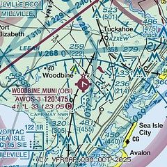
| Sectional chart |
|---|
|
| Airport distance calculator |
|---|
|
|
| Sunrise and sunset |
|---|
|
Times for 01-Aug-2026
| | Local
(UTC-4) | | Zulu
(UTC) |
|---|
| Morning civil twilight | | 05:30 | | 09:30 |
| Sunrise | | 06:00 | | 10:00 |
| Sunset | | 20:11 | | 00:11 |
| Evening civil twilight | | 20:40 | | 00:40 |
|
| Current date and time |
|---|
| Zulu (UTC) | 01-Aug-2026 19:51:48 |
|---|
| Local (UTC-4) | 01-Aug-2026 15:51:48 |
|---|
|
| METAR |
|---|
KWWD
13nm SW | 011856Z AUTO 14011KT 10SM CLR 28/22 A2997 RMK AO2 SLP149 T02830222 $
|
KMIV
16nm NW | 011854Z AUTO 17006KT 10SM CLR 29/19 A2995 RMK AO2 SLP140 T02940189 $
|
KACY
18nm NE | 011854Z 18011G19KT 10SM CLR 29/20 A2996 RMK AO2 SLP144 T02940200
|
|
| TAF |
|---|
KMIV
16nm NW | 011720Z 0118/0218 17009KT P6SM SCT050 BKN250 FM021500 16010G18KT P6SM SCT018 BKN035
|
KACY
18nm NE | 011720Z 0118/0218 18009KT P6SM SCT050 BKN250 FM021700 15011G19KT P6SM SCT010 BKN060
|
|
| NOTAMs |
|---|
NOTAMs are issued by the DoD/FAA and will open in a separate window not controlled by AirNav.
|
|

