FAA INFORMATION EFFECTIVE 09 JULY 2026
Location
| FAA Identifier: | OXR |
| Lat/Long: | 34-12-02.9050N 119-12-26.0150W
34-12.048417N 119-12.433583W
34.2008069,-119.2072264
(estimated) |
| Elevation: | 44.8 ft. / 13.7 m (surveyed) |
| Variation: | 15E (1980) |
| From city: | 1 mile W of OXNARD, CA |
| Time zone: | UTC -7 (UTC -8 during Standard Time) |
| Zip code: | 93030 |
Airport Operations
| Airport use: | Open to the public |
| Activation date: | 04/1942 |
| Control tower: | yes |
| ARTCC: | LOS ANGELES CENTER |
| FSS: | HAWTHORNE FLIGHT SERVICE STATION |
| NOTAMs facility: | OXR (NOTAM-D service available) |
| Attendance: | 0500-0030 |
| Pattern altitude: | TPA 1000 AGL SNGL ENG; 1400 AGL MULTI-ENG & JETS. |
| Wind indicator: | lighted |
| Segmented circle: | yes |
| Lights: | WHEN ATCT CLSD, ACTVT MALSF RWY 25, REIL RWY 07, MIRL RWY 07-25 - CTAF. |
| Beacon: | white-green (lighted land airport)
Operates sunset to sunrise. |
| Landing fee: | no, LANDING FEE OVER 12500 LBS. |
| Fire and rescue: | ARFF index A |
| Airline operations: | UNSKED ACR OPNS INVOLVING ACFT WITH MORE THAN 9 PAX SEATS ARE NOT AUTHD WO PRIOR COORD WITH ARPT AND CFMN THAT ARFF SVCS ARE AVBL PRIOR TO LDG OR TKOF, CTC 805-947-6804. |
Airport Communications
| CTAF: | 134.95 |
| ATIS: | 118.05 |
| WX ASOS: | PHONE 805-382-0569 |
| OXNARD GROUND: | 121.9 [0700-2100] |
| OXNARD TOWER: | 134.95 257.8 [0700-2100] |
| POINT MUGU APPROACH: | 124.7 |
| POINT MUGU DEPARTURE: | 124.7 |
| GUERA STAR: | 120.4 |
| WX ASOS at CMA (6 nm E): | 126.025 (805-384-9294) |
- APCH/DEP CTL SVC PRVDD BY LOS ANGELES ARTCC (ZLA) ON FREQ 135.5/327.1.(SANTA BARBARA RCAG) WHEN POINT MAGU APCH CTL (NTD) CLSD.
- FOR AFTR HRS IFR CLNC DEL CTC LOS ANGELES ARTCC 661 575-2052.
Nearby radio navigation aids
| VOR radial/distance | | VOR name | | Freq | | Var |
|---|
| CMAr248/5.6 | | CAMARILLO VOR/DME | | 116.85 | | 15E |
| VTUr288/9.4 | | VENTURA VOR/DME | | 116.55 | | 15E |
| FIMr225/18.7 | | FILLMORE VORTAC | | 112.50 | | 15E |
| RZSr110/33.5 | | SAN MARCUS VORTAC | | 114.90 | | 14E |
| VNYr253/35.5 | | VAN NUYS VOR/DME | | 113.10 | | 15E |
| SMOr272/39.0 | | SANTA MONICA VOR/DME | | 110.80 | | 15E |
Airport Services
| Fuel available: | 100LL JET-A |
| Parking: | tiedowns |
| Airframe service: | MAJOR |
| Powerplant service: | MAJOR |
| Bottled oxygen: | NONE |
| Bulk oxygen: | HIGH/LOW |
Runway Information
Runway 7/25
| Dimensions: | 5953 x 100 ft. / 1814 x 30 m |
| Surface: | asphalt, in fair condition |
| Weight bearing capacity: | | Single wheel: | 91.0 | | Double wheel: | 126.0 | | Double tandem: | 174.0 | | Dual double tandem: | 117.0 |
|
| Runway edge lights: | medium intensity |
| RUNWAY 7 | | RUNWAY 25 |
| Latitude: | 34-12.052868N | | 34-12.043913N |
| Longitude: | 119-13.024135W | | 119-11.843033W |
| Elevation: | 33.5 ft. | | 44.7 ft. |
| Traffic pattern: | left
UPON REQUEST. | | left |
| Runway heading: | 076 magnetic, 091 true | | 256 magnetic, 271 true |
| Displaced threshold: | no | | 453 ft. |
| Declared distances: | TORA:5953 TODA:5953 ASDA:5654 LDA:5654 | | TORA:5953 TODA:5953 ASDA:5953 LDA:5500 |
| Markings: | nonprecision, in fair condition | | precision, in fair condition |
| Visual slope indicator: | 4-light PAPI on right (3.00 degrees glide path) | | 4-light PAPI on left (3.00 degrees glide path) |
| Approach lights: | | | MALSF: 1,400 foot medium intensity approach lighting system with sequenced flashers |
| Runway end identifier lights: | yes | | |
| Touchdown point: | yes, no lights | | yes, no lights |
| Instrument approach: | | | ILS |
| Obstructions: | none | | 70 ft. pole, 2300 ft. from runway, 210 ft. left of centerline, 30:1 slope to clear
45:1 DSPLCD THR. 123 FT AGL SPIRE DSPLCD 200 FT LEFT. |
Airport Ownership and Management from official FAA records
| Ownership: | Publicly-owned |
| Owner: | COUNTY OF VENTURA
555 AIRPORT WAY
CAMARILLO, CA 93010
Phone 805-388-4372 |
| Manager: | KEITH FREITAS
2889 W 5TH ST
OXNARD, CA 93030
Phone 805-388-4372
ARPT OPNS SUPVR. ADDNL CTC DIR OF ARPTS - KEITH FREITAS 805-388-4200. |
Additional Remarks
| A39-07/25 | PCR VALUE: 371/F/D/X/T |
| - | NO TOUCH & GO, STOP & GO, OR TAXI BACK OPNS 2000-0700 LCL AFTER THREE CONSECUTIVE PATS, THEN TAXI BACK ONLY. |
| - | ARPT OPNS LCTD AT BASE OF ATCT; CTC ON 134.95 WHEN ATCT CLSD OR CALL 805-947-6804. |
| - | FLY FRIENDLY PROCS IN EFCT. AVOID HIGH PWR SETTINGS OVER RESIDENTIAL AREA. KEEP DNWND NORTH OF WOOLEY RD. TURN LEFT CROSSWIND LEG BFR CANAL OR FLY 1/2 MILE PAST SHORELINE. EXP RIGHT TFC RWY 25. SEE ARPT WEBSITE FOR FULL PROC. |
| - | WILDLIFE ON AND INVOF AIRPORT. |
| - | ARPT OPNS SUPVR ADDNL CTC DIR OF ARPTS - (805) 388-4200. |
| - | PRCHT JUMPING SW CORNER OF ARPT. |
Instrument Procedures
NOTE: All procedures below are presented as PDF files. If you need a reader for these files, you should download the free Adobe Reader.NOT FOR NAVIGATION. Please procure official charts for flight.
FAA instrument procedures published for use from 09 July 2026 at 0901Z to 06 August 2026 at 0900Z.
STARs - Standard Terminal Arrivals |
|---|
| GUERA TWO (RNAV) **NEW** | |
2 pages:
[1] [2] (399KB) |
IAPs - Instrument Approach Procedures |
|---|
| ILS OR LOC RWY 25 | |
download (366KB) |
| RNAV (GPS) RWY 07 | |
download (299KB) |
| RNAV (GPS) RWY 25 | |
download (354KB) |
| VOR RWY 25 | |
download (359KB) |
| NOTE: Special Alternate Minimums apply | |
download (141KB) |
Departure Procedures |
|---|
| CAMARILLO SIX | |
download (220KB) |
| SKIFF SEVEN | |
download (232KB) |
| NOTE: Special Take-Off Minimums/Departure Procedures apply | |
download (132KB) |
Other nearby airports with instrument procedures:
KCMA - Camarillo Airport (6 nm E)
KNTD - Point Mugu Naval Air Station (Naval Base Ventura County) (7 nm SE)
KSBA - Santa Barbara Municipal Airport (34 nm NW)
KVNY - Van Nuys Airport (36 nm E)
KSMO - Santa Monica Municipal Airport (39 nm E)
|
|

Road maps at:
MapQuest
Bing
Google
| Aerial photo |
|---|
WARNING: Photo may not be current or correct
 Photo by Fred Emmert AirViews.com
Photo taken 23-Jun-2015
looking west.
Photo by Fred Emmert AirViews.com
Photo taken 23-Jun-2015
looking west.
Do you have a better or more recent aerial photo of Oxnard Airport that you would like to share? If so, please send us your photo.
|
| Sectional chart |
|---|
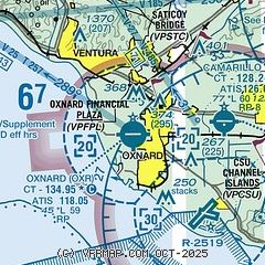
|
CAUTION: Diagram may not be current
 Download PDF
of official airport diagram from the FAA
| Airport distance calculator |
|---|
|
|
| Sunrise and sunset |
|---|
|
Times for 02-Aug-2026
| | Local
(UTC-7) | | Zulu
(UTC) |
|---|
| Morning civil twilight | | 05:42 | | 12:42 |
| Sunrise | | 06:10 | | 13:10 |
| Sunset | | 19:56 | | 02:56 |
| Evening civil twilight | | 20:24 | | 03:24 |
|
| Current date and time |
|---|
| Zulu (UTC) | 02-Aug-2026 22:53:34 |
|---|
| Local (UTC-7) | 02-Aug-2026 15:53:34 |
|---|
|
| METAR |
|---|
| KOXR | 022233Z 28013KT 9SM SCT008 22/18 A2982 RMK AO2 T02220178
|
KNTD
7nm SE | 022221Z 26008KT 5SM HZ BKN009 24/18 A2983 RMK AO2 T02390183 VISNO S $
|
KCMA
7nm E | 022155Z 26008KT 10SM CLR 26/18 A2983 RMK AO2 SLP109 T02560183 $
|
|
| TAF |
|---|
| KOXR | 022147Z 0222/0318 25010KT P6SM BKN008 FM022300 26012KT 6SM HZ SCT010 FM030400 25006KT P6SM SCT008 FM030900 VRB03KT 4SM BR OVC006 FM031700 26010KT P6SM FEW008
|
KNTD
7nm SE | 021900Z 0219/0315 23006KT 9000 HZ BKN010 QNH2979INS TEMPO 0219/0301 9999 FEW010 BECMG 0305/0307 VRB06KT 9000 BR BKN010 QNH2980INS TEMPO 0311/0315 3200 BR OVC010 TX26/0222Z TN16/0312Z AMD 1916 FS30237
|
KCMA
7nm E | 021746Z 0218/0318 VRB03KT 6SM HZ FEW008 FM022000 25010KT P6SM SKC FM030500 VRB03KT P6SM SKC FM031200 VRB03KT 2SM BR BKN004 FM031600 24008KT P6SM SKC
|
|
| NOTAMs |
|---|
NOTAMs are issued by the DoD/FAA and will open in a separate window not controlled by AirNav.
|
|


