FAA INFORMATION EFFECTIVE 14 MAY 2026
Location
| FAA Identifier: | RWI |
| Lat/Long: | 35-51-22.5100N 077-53-30.9600W
35-51.375167N 077-53.516000W
35.8562528,-77.8919333
(estimated) |
| Elevation: | 157.7 ft. / 48.1 m (surveyed) |
| Variation: | 09W (2005) |
| From city: | 7 miles SW of ROCKY MOUNT, NC |
| Time zone: | UTC -4 (UTC -5 during Standard Time) |
| Zip code: | 27822 |
Airport Operations
| Airport use: | Open to the public |
| Control tower: | no |
| ARTCC: | WASHINGTON CENTER |
| FSS: | RALEIGH FLIGHT SERVICE STATION |
| NOTAMs facility: | RWI (NOTAM-D service available) |
| Attendance: | SAT-SUN 0800-1800, ALL MON-FRI 0800-1900 |
| Wind indicator: | lighted |
| Segmented circle: | yes |
| Lights: | PAPI RWY 04 & 22 OPR CONSLY. ACTVT MALSR RWY 04; REIL RWY 22; HIRL RWY 04/22 - CTAF. |
| Beacon: | white-green (lighted land airport)
Operates sunset to sunrise. |
| Fire and rescue: | ARFF index A |
| Airline operations: | CLSD TO ACR OPNS WITH MORE THAN 30 PSGR SEATS EXCP 24 HR PPR CALL AMGR 252-446-7057. |
Airport Communications
| CTAF/UNICOM: | 123.05 |
| WX ASOS: | 118.875 (252-446-0732) |
| WX AWOS-3P at ETC (17 nm E): | 119.575 (252-641-1640) |
- APCH/DEP SVC PRVDD BY WASHINGTON ARTCC (ZDC) ON 123.85/279.65 (NEW BERN RCAG).
Nearby radio navigation aids
| VOR radial/distance | | VOR name | | Freq | | Var |
|---|
| TYIr237/11.7 | | TAR RIVER VORTAC | | 117.80 | | 05W |
| ISOr336/33.4 | | KINSTON VORTAC | | 117.50 | | 05W |
| NDB name | | Hdg/Dist | | Freq | | Var | | ID |
|---|
| ALWOOD | | 298/26.9 | | 230 | | 09W | | AQE | .- --.- . |
Airport Services
| Fuel available: | 100LL JET-A |
| Parking: | hangars and tiedowns |
| Airframe service: | MAJOR |
| Powerplant service: | MAJOR |
| Bottled oxygen: | NONE |
| Bulk oxygen: | HIGH |
Runway Information
Runway 4/22
| Dimensions: | 7099 x 150 ft. / 2164 x 46 m |
| Surface: | asphalt/grooved, in good condition |
| Weight bearing capacity: | | Single wheel: | 101.0 | | Double wheel: | 162.0 |
|
| Runway edge lights: | high intensity |
| RUNWAY 4 | | RUNWAY 22 |
| Latitude: | 35-50.885933N | | 35-51.863893N |
| Longitude: | 077-53.910548W | | 077-53.121623W |
| Elevation: | 157.7 ft. | | 150.3 ft. |
| Traffic pattern: | left | | left |
| Runway heading: | 042 magnetic, 033 true | | 222 magnetic, 213 true |
| Declared distances: | TORA:7100 TODA:7100 ASDA:7100 LDA:7100 | | TORA:7100 TODA:7100 ASDA:6900 LDA:6900 |
| Markings: | precision, in good condition | | precision, in good condition |
| Visual slope indicator: | 4-light PAPI on left (3.00 degrees glide path) | | 4-light PAPI on left (3.00 degrees glide path) |
| Approach lights: | MALSR: 1,400 foot medium intensity approach lighting system with runway alignment indicator lights | | |
| Runway end identifier lights: | | | yes |
| Touchdown point: | yes, no lights | | yes, no lights |
| Instrument approach: | ILS/DME | | |
| Obstructions: | 21 ft. trees, 1173 ft. from runway, 51 ft. right of centerline, 46:1 slope to clear | | 56 ft. trees, 2100 ft. from runway, 34:1 slope to clear |
Airport Ownership and Management from official FAA records
| Ownership: | Publicly-owned |
| Owner: | ROCKY MOUNT-WILSON ARPT AUTH
7265 AIR TERMINAL DR
ELM CITY, NC 27822
Phone 252-446-7057 |
| Manager: | JOSH PUSSER
7265 AIR TERMINAL DR
ELM CITY, NC 27822
Phone 252-446-3189
ALT PHONE NUMBER: 252-469-8817. |
Additional Remarks
| A39-04/22 | PCR VALUE: 600/F/A/W/T |
| - | FOR CD IF UNA TO CTC ON FSS FREQ, CTC WASHINGTON ARTCC AT 703-771-3587. |
Instrument Procedures
NOTE: All procedures below are presented as PDF files. If you need a reader for these files, you should download the free Adobe Reader.NOT FOR NAVIGATION. Please procure official charts for flight.
FAA instrument procedures published for use from 14 May 2026 at 0901Z to 11 June 2026 at 0900Z.
IAPs - Instrument Approach Procedures |
|---|
| ILS OR LOC RWY 04 | |
download (209KB) |
| RNAV (GPS) RWY 04 | |
download (263KB) |
| RNAV (GPS) RWY 22 | |
download (260KB) |
| NOTE: Special Alternate Minimums apply | |
download (168KB) |
| NOTE: Special Take-Off Minimums/Departure Procedures apply | |
download (356KB) |
Other nearby airports with instrument procedures:
W03 - Wilson Industrial Air Center Airport (6 nm SW)
KETC - Tarboro-Edgecombe Airport (17 nm E)
KLHZ - Triangle North Executive Airport (24 nm NW)
KGWW - Wayne Executive Jetport Airport (24 nm S)
KPGV - Pitt-Greenville Airport (28 nm SE)
|
|

Road maps at:
MapQuest
Bing
Google
| Aerial photo |
|---|
WARNING: Photo may not be current or correct
 Photo by Brian Corley
Photo taken 01-Jan-2015
looking west.
Photo by Brian Corley
Photo taken 01-Jan-2015
looking west.
Do you have a better or more recent aerial photo of Rocky Mount/Wilson Regional Airport that you would like to share? If so, please send us your photo.
|
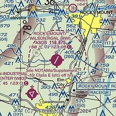
| Sectional chart |
|---|
|
CAUTION: Diagram may not be current

| Airport distance calculator |
|---|
|
|
| Sunrise and sunset |
|---|
|
Times for 05-Jun-2026
| | Local
(UTC-4) | | Zulu
(UTC) |
|---|
| Morning civil twilight | | 05:27 | | 09:27 |
| Sunrise | | 05:56 | | 09:56 |
| Sunset | | 20:24 | | 00:24 |
| Evening civil twilight | | 20:53 | | 00:53 |
|
| Current date and time |
|---|
| Zulu (UTC) | 06-Jun-2026 00:45:01 |
|---|
| Local (UTC-4) | 05-Jun-2026 20:45:01 |
|---|
|
| METAR |
|---|
| KRWI | 052353Z AUTO 21006KT 10SM CLR 31/11 A3001 RMK AO2 SLP160 T03060106 10350 20306 55003
|
KETC
17nm E | 060035Z AUTO 19004KT 10SM CLR 29/13 A3000 RMK AO2 T02870125
|
|
| TAF |
|---|
| KRWI | 051720Z 0518/0618 VRB04KT P6SM FEW250 FM061300 20006KT P6SM FEW250
|
|
| NOTAMs |
|---|
NOTAMs are issued by the DoD/FAA and will open in a separate window not controlled by AirNav.
|
|


