FAA INFORMATION EFFECTIVE 14 MAY 2026
Location
| FAA Identifier: | RWN |
| Lat/Long: | 41-05-32.1470N 086-36-46.3360W
41-05.535783N 086-36.772267W
41.0922631,-86.6128711
(estimated) |
| Elevation: | 708.3 ft. / 215.9 m (surveyed) |
| Variation: | 03W (2000) |
| From city: | 3 miles N of WINAMAC, IN |
| Time zone: | UTC -4 (UTC -5 during Standard Time) |
| Zip code: | 46996 |
Airport Operations
| Airport use: | Open to the public |
| Activation date: | 08/1969 |
| Control tower: | no |
| ARTCC: | CHICAGO CENTER |
| FSS: | TERRE HAUTE FLIGHT SERVICE STATION |
| NOTAMs facility: | HUF (NOTAM-D service available) |
| Attendance: | MON-FRI 0900-1700 |
| Wind indicator: | lighted |
| Segmented circle: | no |
| Lights: | ACTVT REIL RWY 09 & 27; PAPI RWY 09 & 27; MIRL RWY 09/27 - CTAF. |
Airport Communications
| CTAF/UNICOM: | 122.8 |
| SOUTH BEND APPROACH: | 132.05 |
| SOUTH BEND DEPARTURE: | 132.05 |
| WX AWOS-3P at OXI (14 nm N): | 135.775 (574-772-2041) |
| WX AWOS-3 at RCR (20 nm E): | 118.775 (574-223-3560) |
- APCH/DEP SVC PRVDD BY CHICAGO ARTCC ON FREQS 119.85/307.375 (FORT WAYNE RCAG); WHEN SOUTH BEND APCH CTL CLSD.
Nearby radio navigation aids
| VOR radial/distance | | VOR name | | Freq | | Var |
|---|
| BVTr032/38.3 | | BOILER VORTAC | | 115.10 | | 01E |
Airport Services
| Fuel available: | 100LL JET-A
A:SELF SERVICE. |
| Parking: | hangars and tiedowns |
| Airframe service: | NONE |
| Powerplant service: | NONE |
| Bottled oxygen: | NONE |
| Bulk oxygen: | NONE |
Runway Information
Runway 9/27
| Dimensions: | 4201 x 75 ft. / 1280 x 23 m
300 FT STWY ON WEST END. |
| Surface: | asphalt/grooved, in good condition |
| Weight bearing capacity: | | Single wheel: | EST SINGLE WHEEL PAVEMENT STRENGTH 12000 LBS. |
|
| Runway edge lights: | medium intensity |
| RUNWAY 9 | | RUNWAY 27 |
| Latitude: | 41-05.536993N | | 41-05.534467N |
| Longitude: | 086-37.229102W | | 086-36.314678W |
| Elevation: | 705.6 ft. | | 706.7 ft. |
| Traffic pattern: | left | | left |
| Runway heading: | 093 magnetic, 090 true | | 273 magnetic, 270 true |
| Displaced threshold: | no | | 560 ft. |
| Markings: | nonprecision, in good condition | | nonprecision, in good condition |
| Visual slope indicator: | 2-light PAPI on left (3.00 degrees glide path) | | 2-light PAPI on left (3.50 degrees glide path) |
| Runway end identifier lights: | yes
REIL OTS INDEFLY. | | yes |
| Touchdown point: | yes, no lights | | yes, no lights |
| Obstructions: | 10 ft. road, 430 ft. from runway, 23:1 slope to clear
4 FT FENCE 200 FT N. | | 26 ft. tree, 350 ft. from runway, 170 ft. left of centerline, 5:1 slope to clear |
Airport Ownership and Management from official FAA records
| Ownership: | Publicly-owned |
| Owner: | WINAMAC-PULASKI CO BOAC
2595N. US 35
WINAMAC, IN 46996
Phone 574-946-6785 |
| Manager: | DARYN WILDER
2595 N. US 35
WINAMAC, IN 46996
Phone 574-946-6785 |
Additional Remarks
| - | FOR CD CTC SOUTH BEND APCH AT 574-251-2609. WHEN SOUTH BEND APCH CLSD, FOR CD CTC CHICAGO ARTCC AT 630-906-8921. |
| - | (CONTACT TITLE) JIM MCDANIEL. |
Instrument Procedures
NOTE: All procedures below are presented as PDF files. If you need a reader for these files, you should download the free Adobe Reader.NOT FOR NAVIGATION. Please procure official charts for flight.
FAA instrument procedures published for use from 14 May 2026 at 0901Z to 11 June 2026 at 0900Z.
IAPs - Instrument Approach Procedures |
|---|
| RNAV (GPS) RWY 09 **CHANGED** | |
download (215KB) |
| RNAV (GPS) RWY 27 **CHANGED** | |
download (217KB) |
| NOTE: Special Take-Off Minimums/Departure Procedures apply | |
download (460KB) |
Other nearby airports with instrument procedures:
KOXI - Starke County Airport (14 nm N)
KRCR - Fulton County Airport (20 nm E)
C65 - Plymouth Municipal Airport (22 nm NE)
KMCX - White County Airport (24 nm S)
KGGP - Logansport/Cass County Airport (25 nm SE)
|
|

Road maps at:
MapQuest
Bing
Google
| Aerial photo |
|---|
WARNING: Photo may not be current or correct

Do you have a better or more recent aerial photo of Arens Field Airport that you would like to share? If so, please send us your photo.
|
| Sectional chart |
|---|
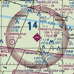
|
| Airport distance calculator |
|---|
|
|
| Sunrise and sunset |
|---|
|
Times for 02-Jun-2026
| | Local
(UTC-4) | | Zulu
(UTC) |
|---|
| Morning civil twilight | | 05:44 | | 09:44 |
| Sunrise | | 06:17 | | 10:17 |
| Sunset | | 21:12 | | 01:12 |
| Evening civil twilight | | 21:45 | | 01:45 |
|
| Current date and time |
|---|
| Zulu (UTC) | 02-Jun-2026 14:44:56 |
|---|
| Local (UTC-4) | 02-Jun-2026 10:44:56 |
|---|
|
| METAR |
|---|
KOXI
14nm N | 021435Z AUTO 11009KT 10SM CLR 22/07 A3031 RMK AO2
|
KRCR
20nm E | 021435Z AUTO 09010KT 9SM CLR 21/05 A3031 RMK AO2
|
KC65
22nm NE | 021435Z AUTO 11007KT 10SM CLR 21/05 A3031 RMK A01
|
KMCX
24nm S | 021435Z AUTO 07006KT 10SM CLR 21/04 A3030 RMK AO2 T02100044
|
KGGP
25nm SE | 021419Z AUTO 06005KT 1 1/2SM HZ 19/07 A3031 RMK AO2
|
KRZL
27nm W | 021435Z AUTO 08009G14KT 10SM CLR 21/03 A3031 RMK AO2
|
KVPZ
28nm NW | 021356Z AUTO 12010KT 10SM CLR 20/06 A3033 RMK AO2 SLP267 T02000061 TSNO
|
|
| TAF |
|---|
KGUS
35nm SE | 021300Z 0213/0319 07010KT 9999 SCT200 QNH3027INS TEMPO 0217/0221 05015G25KT BECMG 0202/0203 VRB06KT 9999 SKC QNH3031INS TX24/0218Z TN11/0311Z
|
KSBN
39nm N | 021120Z 0212/0312 07006KT P6SM FEW150
|
|
| NOTAMs |
|---|
NOTAMs are issued by the DoD/FAA and will open in a separate window not controlled by AirNav.
|
|

