FAA INFORMATION EFFECTIVE 11 JUNE 2026
Location
| FAA Identifier: | SMQ |
| Lat/Long: | 40-37-33.5303N 074-40-12.1138W
40-37.558838N 074-40.201897W
40.6259806,-74.6700316
(estimated) |
| Elevation: | 106.2 ft. / 32.4 m (surveyed) |
| Variation: | 13W (2000) |
| From city: | 3 miles N of SOMERVILLE, NJ |
| Time zone: | UTC -4 (UTC -5 during Standard Time) |
| Zip code: | 07921 |
Airport Operations
| Airport use: | Open to the public |
| Activation date: | 08/1946 |
| Control tower: | no |
| ARTCC: | NEW YORK CENTER |
| FSS: | MILLVILLE FLIGHT SERVICE STATION |
| NOTAMs facility: | SMQ (NOTAM-D service available) |
| Attendance: | 0800-1700
UNATTENDED THANKSGIVING, CHRISTMAS & NEW YEARS. |
| Wind indicator: | lighted |
| Segmented circle: | no |
| Lights: | ACTVT REIL RWY 12 & 30; PAPI RWY 12 & 30; MIRL RWY 12/30 - 118.325. |
| Beacon: | white-green (lighted land airport)
Operates sunset to sunrise. |
Airport Communications
| CTAF/UNICOM: | 123.0 |
| WX ASOS: | 120.6 (908-722-2139) |
| NEWARK APPROACH: | 132.8 |
| NEWARK DEPARTURE: | 132.8 |
| JAIKE STAR: | 132.8 |
| WILKES-BARRE STAR: | 127.6 |
| WX AWOS-3 at N40 (15 nm W): | 121.725 |
| WX AWOS-3 at MMU (16 nm NE): | PHONE 973-290-0135 |
| WX AWOS-3 at LDJ (19 nm E): | 124.025 (908-862-7383) |
Nearby radio navigation aids
| VOR radial/distance | | VOR name | | Freq | | Var |
|---|
| SBJr062/4.2 | | SOLBERG VOR/DME | | 112.90 | | 10W |
| BWZr157/12.4 | | BROADWAY VOR/DME | | 114.20 | | 11W |
| STWr169/24.0 | | STILLWATER VOR/DME | | 109.60 | | 11W |
| ARDr036/24.9 | | YARDLEY VOR/DME | | 108.20 | | 10W |
| RBVr353/26.6 | | ROBBINSVILLE VORTAC | | 113.80 | | 10W |
| SAXr204/27.2 | | SPARTA VORTAC | | 115.70 | | 11W |
| COLr320/30.0 | | COLTS NECK VOR/DME | | 115.40 | | 11W |
| TEBr255/30.7 | | TETERBORO VOR/DME | | 108.40 | | 11W |
| CRIr282/35.3 | | CANARSIE VOR/DME | | 112.30 | | 11W |
| FJCr110/36.2 | | ALLENTOWN VORTAC | | 117.50 | | 10W |
| GXUr007/37.1 | | MC GUIRE VORTAC | | 110.60 | | 12W |
| LGAr267/37.7 | | LA GUARDIA VOR/DME | | 113.10 | | 12W |
| NDB name | | Hdg/Dist | | Freq | | Var | | ID |
|---|
| LAKEHURST | | 347/38.1 | | 396 | | 11W | | NEL | -. . .-.. |
Airport Services
| Fuel available: | 100LL JET-A |
| Parking: | hangars and tiedowns |
| Airframe service: | MAJOR |
| Powerplant service: | MAJOR |
| Bottled oxygen: | HIGH/LOW |
| Bulk oxygen: | HIGH/LOW |
Runway Information
Runway 12/30
| Dimensions: | 2739 x 65 ft. / 835 x 20 m |
| Surface: | asphalt, in good condition |
| Runway edge lights: | medium intensity |
| RUNWAY 12 | | RUNWAY 30 |
| Latitude: | 40-37.614870N | | 40-37.468265N |
| Longitude: | 074-40.516095W | | 074-39.956323W |
| Elevation: | 83.9 ft. | | 102.1 ft. |
| Traffic pattern: | left | | left |
| Runway heading: | 122 magnetic, 109 true | | 302 magnetic, 289 true |
| Displaced threshold: | no | | 200 ft. |
| Markings: | nonprecision, in good condition | | nonprecision, in good condition |
| Visual slope indicator: | 2-light PAPI on right (3.00 degrees glide path) | | 2-light PAPI on left (4.00 degrees glide path) |
| Runway end identifier lights: | yes | | yes |
| Touchdown point: | yes, no lights | | yes, no lights |
| Obstructions: | 55 ft. trees, 587 ft. from runway, 163 ft. right of centerline, 7:1 slope to clear | | 65 ft. trees, 795 ft. from runway, 280 ft. left of centerline, 9:1 slope to clear
APCH RATIO 15:1 TO DTHR. |
Runway 8/26
| Dimensions: | 1923 x 100 ft. / 586 x 30 m |
| Surface: | turf, in good condition |
| Operational restrictions: | 550 FT W END UNSUITABLE FOR TKOF OR LDG DUE TO UNEVEN SFC. |
| RUNWAY 8 | | RUNWAY 26 |
| Latitude: | 40-37.579808N | | 40-37.691645N |
| Longitude: | 074-40.305023W | | 074-39.916262W |
| Elevation: | 95.0 ft. | | 102.9 ft. |
| Traffic pattern: | left | | right |
| Runway heading: | 082 magnetic, 069 true | | 262 magnetic, 249 true |
| Markings: | none | | none |
| Touchdown point: | yes, no lights | | yes, no lights |
| Obstructions: | 51 ft. tree, 200 ft. from runway, 50 ft. left of centerline, 3:1 slope to clear | | 45 ft. tree, 10 ft. from runway, 140 ft. right of centerline |
Runway 17/35
| Dimensions: | 1700 x 150 ft. / 518 x 46 m |
| Surface: | turf, in good condition |
| RUNWAY 17 | | RUNWAY 35 |
| Latitude: | 40-37.632450N | | 40-37.366937N |
| Longitude: | 074-40.308167W | | 074-40.191508W |
| Elevation: | 97.2 ft. | | 87.4 ft. |
| Traffic pattern: | left | | left |
| Runway heading: | 174 magnetic, 161 true | | 354 magnetic, 341 true |
| Markings: | none | | none |
| Touchdown point: | yes, no lights | | yes, no lights |
| Obstructions: | 65 ft. trees, 20 ft. from runway, 120 ft. right of centerline | | 22 ft. trees, 10 ft. from runway, 90 ft. left of centerline |
Airport Ownership and Management from official FAA records
| Ownership: | Privately-owned |
| Owner: | SOMERSET AIR SERVICE, INC
PO BOX 1007
BEDMINSTER, NJ 07921
Phone 908-722-2444 |
| Manager: | CHRIS WALKER, PRES.
PO BOX 1007
BEDMINSTER, NJ 07921
Phone 908-722-2444 |
Additional Remarks
| - | FOR CD CTC NEWARK APCH AT 800-645-3206. |
| - | DEER AND BIRDS ON AND INVOF ARPT |
| - | NO TGL. |
Instrument Procedures
NOTE: All procedures below are presented as PDF files. If you need a reader for these files, you should download the free Adobe Reader.NOT FOR NAVIGATION. Please procure official charts for flight.
FAA instrument procedures published for use from 11 June 2026 at 0901Z to 09 July 2026 at 0900z.
STARs - Standard Terminal Arrivals |
|---|
| JAIKE FOUR (RNAV) **NEW** | |
2 pages:
[1] [2] (364KB) |
| MAZIE THREE (RNAV) **NEW** | |
download (199KB) |
| WILKES-BARRE FIVE **NEW** | |
download (181KB) |
IAPs - Instrument Approach Procedures |
|---|
| RNAV (GPS) RWY 12 **CHANGED** | |
download (211KB) |
| RNAV (GPS) RWY 30 **CHANGED** | |
download (206KB) |
| VOR RWY 08 **CHANGED** | |
download (185KB) |
| NOTE: Special Alternate Minimums apply | |
download (126KB) |
| NOTE: Special Take-Off Minimums/Departure Procedures apply | |
download (150KB) |
Other nearby airports with instrument procedures:
N51 - Solberg/Hunterdon Airport (4 nm SW)
47N - Central Jersey Regional Airport (7 nm SE)
39N - Princeton Airport (14 nm S)
N40 - Sky Manor Airport (15 nm W)
KMMU - Morristown Municipal Airport (16 nm NE)
N85 - Alexandria Airport (16 nm W)
KLDJ - Linden Airport (19 nm E)
|
|

Road maps at:
MapQuest
Bing
Google
| Aerial photo |
|---|
WARNING: Photo may not be current or correct
 Photo by Joshua Weinstein
Photo taken 20-Aug-2020
looking east.
Photo by Joshua Weinstein
Photo taken 20-Aug-2020
looking east.
Do you have a better or more recent aerial photo of Somerset Airport that you would like to share? If so, please send us your photo.
|
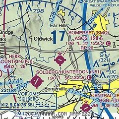
| Sectional chart |
|---|
|
| Airport distance calculator |
|---|
|
|
| Sunrise and sunset |
|---|
|
Times for 08-Jul-2026
| | Local
(UTC-4) | | Zulu
(UTC) |
|---|
| Morning civil twilight | | 05:04 | | 09:04 |
| Sunrise | | 05:36 | | 09:36 |
| Sunset | | 20:31 | | 00:31 |
| Evening civil twilight | | 21:04 | | 01:04 |
|
| Current date and time |
|---|
| Zulu (UTC) | 08-Jul-2026 18:55:17 |
|---|
| Local (UTC-4) | 08-Jul-2026 14:55:17 |
|---|
|
| METAR |
|---|
| KSMQ | ASOS 120.60 908-722-2139
081753Z AUTO 16004KT 9SM FEW045 29/19 A3001 RMK AO2 SLP160 T02890189 10289 20183 58013
|
KMMU
15nm NE | 081745Z 00000KT 10SM SCT036 28/18 A3003
|
KLDJ
19nm E | 081835Z AUTO 27005KT 10SM CLR 29/15 A3001 RMK AO2 T02940151
|
|
| TAF |
|---|
KTTN
22nm S | 081132Z 0812/0912 03005KT P6SM FEW025 FM081800 18006KT P6SM FEW080 SCT250
|
KEWR
23nm E | 081740Z 0818/0924 23007KT P6SM FEW035 FM082000 20008KT P6SM FEW250 FM090500 22006KT P6SM FEW060 FM091700 22010KT P6SM BKN100 PROB30 0918/0921 3SM TSRA BKN040CB
|
|
| NOTAMs |
|---|
NOTAMs are issued by the DoD/FAA and will open in a separate window not controlled by AirNav.
|
|


