FAA INFORMATION EFFECTIVE 16 APRIL 2026
Location
| FAA Identifier: | N40 |
| Lat/Long: | 40-33-57.1760N 074-58-45.5090W
40-33.952933N 074-58.758483W
40.5658822,-74.9793081
(estimated) |
| Elevation: | 560 ft. / 171 m (estimated) |
| Variation: | 13W (2010) |
| From city: | 2 miles SW of PITTSTOWN, NJ |
| Time zone: | UTC -4 (UTC -5 during Standard Time) |
| Zip code: | 08867 |
Airport Operations
| Airport use: | Open to the public |
| Activation date: | 03/1947 |
| Control tower: | no |
| ARTCC: | NEW YORK CENTER |
| FSS: | MILLVILLE FLIGHT SERVICE STATION |
| NOTAMs facility: | MIV (NOTAM-D service available) |
| Attendance: | CONTINUOUS |
| Wind indicator: | yes |
| Segmented circle: | no |
| Lights: | ACTVT REIL RWY 07 & 25; MIRL RWY 07/25; TWY LGTS - CTAF. PAPI RWY 07 & 25 OPR CONSLY. |
Airport Communications
| CTAF/UNICOM: | 122.975 |
| WX AWOS-3: | 121.725 |
| ALLENTOWN APPROACH: | 119.65 ;3000 FT & BLW 124.45 ;ABV 3000 FT |
| ALLENTOWN DEPARTURE: | 119.65 ;3000 FT & BLW 124.45 ;ABV 3000 FT |
| IC: | 119.65 ;3000 FT & BLW 124.45 ;ABV 3000 FT |
| WX ASOS at SMQ (15 nm E): | 120.6 (908-722-2139) |
| WX ASOS at DYL (15 nm SW): | 118.875 (215-345-0392) |
| WX AWOS-3 at CKZ (18 nm SW): | 126.325 (215-257-7291) |
| WX ASOS at TTN (19 nm SE): | 126.775 (609-538-8690) |
| WX AWOS-3 at UKT (20 nm SW): | 119.475 (215-538-7610) |
Nearby radio navigation aids
| VOR radial/distance | | VOR name | | Freq | | Var |
|---|
| SBJr275/10.9 | | SOLBERG VOR/DME | | 112.90 | | 10W |
| BWZr218/15.7 | | BROADWAY VOR/DME | | 114.20 | | 11W |
| ARDr000/19.0 | | YARDLEY VOR/DME | | 108.20 | | 10W |
| FJCr124/23.7 | | ALLENTOWN VORTAC | | 117.50 | | 10W |
| STWr202/26.3 | | STILLWATER VOR/DME | | 109.60 | | 11W |
| RBVr325/31.1 | | ROBBINSVILLE VORTAC | | 113.80 | | 10W |
| ETXr101/32.1 | | EAST TEXAS VOR/DME | | 110.20 | | 09W |
| PTWr061/33.6 | | POTTSTOWN VORTAC | | 116.50 | | 09W |
| SAXr225/36.2 | | SPARTA VORTAC | | 115.70 | | 11W |
| GXUr344/37.7 | | MC GUIRE VORTAC | | 110.60 | | 12W |
Airport Services
| Fuel available: | 100LL |
| Parking: | hangars and tiedowns |
| Airframe service: | MAJOR |
| Powerplant service: | MAJOR |
| Bottled oxygen: | NONE |
| Bulk oxygen: | NONE |
Runway Information
Runway 7/25
| Dimensions: | 2900 x 50 ft. / 884 x 15 m |
| Surface: | asphalt, in good condition |
| Runway edge lights: | medium intensity |
| RUNWAY 7 | | RUNWAY 25 |
| Latitude: | 40-33.813333N | | 40-34.092533N |
| Longitude: | 074-59.012667W | | 074-58.504300W |
| Elevation: | 548.0 ft. | | 558.0 ft. |
| Traffic pattern: | left | | left |
| Runway heading: | 067 magnetic, 054 true | | 247 magnetic, 234 true |
| Markings: | nonprecision, in good condition | | nonprecision, in good condition |
| Visual slope indicator: | 2-light PAPI on left (4.00 degrees glide path)
UNUSBL BYD 4 DEGS RIGHT OF CNTRLN. | | 2-light PAPI on left (4.00 degrees glide path) |
| Runway end identifier lights: | yes | | yes |
| Touchdown point: | yes, no lights | | yes, no lights |
| Obstructions: | 93 ft. trees, 1020 ft. from runway, 360 ft. right of centerline, 9:1 slope to clear | | 99 ft. pline, lighted, 2070 ft. from runway, 210 ft. left of centerline, 18:1 slope to clear
13 FT T-HANGARS 80 FT FM THR 215 FT RIGHT. |
Airport Ownership and Management from official FAA records
| Ownership: | Privately-owned |
| Owner: | SKY MANOR AIRPORT PARTNERS LLC
PO BOX 56
PITTSTOWN, NJ 08867
Phone 908-996-4200 |
| Manager: | SKY MANOR AIRPORT PARTNERS LCC
PO BOX 56
PITTSTOWN, NJ 08867
Phone 908-996-4200 |
Additional Remarks
| - | HELICOPTER ACTIVITY ON & INVOF ARPT. |
| - | APN MAIN RAMP CLSD TO HEL AIR TAX AND HOVER OPS NEAR FUEL PUMP. |
| - | DEER & BIRDS ON & INVOF ARPT. |
| - | SELF-SERVE FUEL SYSTEM ON NORTH END OF TIE-DOWN RAMP. |
| - | FOR CD CTC ALLENTOWN APCH AT 800-728-6322. |
| - | AVOID OVERFLIGHT OF HORSE FARM (STABLES) 500 FT N OF ACFT HNGRS. |
| - | RWY 07 NOISE ABATEMENT PROCEDURES VFR DEP FLY RWY HDG UNTIL REACHING AT LEAST 1300FT MSL. |
| - | RWY 25 NOISE ABATEMENT PROCEDURES VFR DEP SAFETY PERMITTING AT DEP END OF RWY TURN RIGHT FLY HDG 270 UNTIL REACHING AT LEAST 1300FT MSL. |
Instrument Procedures
NOTE: All procedures below are presented as PDF files. If you need a reader for these files, you should download the free Adobe Reader.NOT FOR NAVIGATION. Please procure official charts for flight.
FAA instrument procedures published for use from 16 April 2026 at 0901Z to 14 May 2026 at 0900Z.
IAPs - Instrument Approach Procedures |
|---|
| RNAV (GPS) RWY 07 | |
download (166KB) |
| RNAV (GPS) RWY 25 | |
download (168KB) |
| VOR RWY 07 | |
download (187KB) |
| NOTE: Special Alternate Minimums apply | |
download (126KB) |
| NOTE: Special Take-Off Minimums/Departure Procedures apply | |
download (150KB) |
Other nearby airports with instrument procedures:
N85 - Alexandria Airport (2 nm NW)
N51 - Solberg/Hunterdon Airport (11 nm E)
KSMQ - Somerset Airport (15 nm E)
KDYL - Doylestown Airport (15 nm SW)
N43 - Braden Airpark (16 nm NW)
47N - Central Jersey Regional Airport (18 nm E)
39N - Princeton Airport (18 nm SE)
KCKZ - Pennridge Airport (18 nm SW)
KTTN - Trenton Mercer Airport (19 nm SE)
KUKT - Quakertown Airport (20 nm SW)
|
|

Road maps at:
MapQuest
Bing
Google
| Aerial photo |
|---|
WARNING: Photo may not be current or correct
 Photo taken 30-Jul-2017
looking southwest.
Photo taken 30-Jul-2017
looking southwest.
Do you have a better or more recent aerial photo of Sky Manor Airport that you would like to share? If so, please send us your photo.
|
| Sectional chart |
|---|
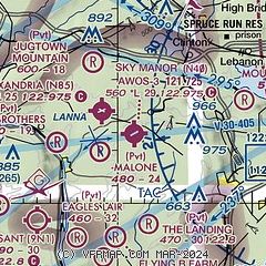
|
| Airport distance calculator |
|---|
|
|
| Sunrise and sunset |
|---|
|
Times for 08-May-2026
| | Local
(UTC-4) | | Zulu
(UTC) |
|---|
| Morning civil twilight | | 05:21 | | 09:21 |
| Sunrise | | 05:51 | | 09:51 |
| Sunset | | 20:01 | | 00:01 |
| Evening civil twilight | | 20:32 | | 00:32 |
|
| Current date and time |
|---|
| Zulu (UTC) | 08-May-2026 12:26:37 |
|---|
| Local (UTC-4) | 08-May-2026 08:26:37 |
|---|
|
| METAR |
|---|
KSMQ
15nm E | ASOS 120.60 908-722-2139
081153Z AUTO VRB06KT 10SM CLR 09/05 A2991 RMK AO2 SLP130 60000 T00940050 10100 20039 53011
|
KDYL
15nm SW | 081154Z AUTO 32005KT 10SM CLR 10/03 A2992 RMK AO2 SLP133 T01000028 10106 20044 50008
|
KCKZ
18nm SW | 081215Z AUTO VRB06KT 10SM CLR 11/03 A2995 RMK AO2
|
KTTN
19nm SE | ASOS 133.70 609-538-8690
081153Z 28004KT 10SM CLR 09/04 A2993 RMK AO2 SLP130 7//// T00940044 10100 20067 53011
|
KUKT
20nm SW | 081215Z AUTO VRB03KT 10SM CLR 11/04 A2994 RMK AO2
|
KABE
22nm W | 081151Z 25004KT 10SM CLR 08/04 A2993 RMK AO2 SLP137 60000 T00830044 10106 20044 51011
|
KXLL
23nm W | 081215Z AUTO 00000KT 10SM SCT070 10/05 A2996 RMK AO2 TSNO
|
KMMU
29nm NE | 081145Z 30004KT 10SM SKC 09/06 A2993
|
KLOM
29nm SW | 081150Z AUTO 25006KT 10SM CLR 10/05 A2995 RMK AO2 T01020050 10110 20045
|
KPNE
29nm S | 081154Z 32008KT 10SM CLR 12/04 A2995 RMK AO2 SLP142 T01170039 10128 20072 51010 $
|
|
| TAF |
|---|
KTTN
19nm SE | 081120Z 0812/0912 31010KT P6SM SKC FM081300 30009KT P6SM FEW060 FM081600 28013G22KT P6SM BKN070 FM090000 VRB03KT P6SM FEW060
|
KABE
22nm W | 081120Z 0812/0912 27007KT P6SM SCT060 FM081500 27013G22KT P6SM SCT060 FM082300 27005KT P6SM SCT050
|
|
| NOTAMs |
|---|
NOTAMs are issued by the DoD/FAA and will open in a separate window not controlled by AirNav.
|
|


