FAA INFORMATION EFFECTIVE 30 OCTOBER 2025
Location
| FAA Identifier: | LDJ |
| Lat/Long: | 40-37-02.8180N 074-14-40.5390W
40-37.046967N 074-14.675650W
40.6174494,-74.2445942
(estimated) |
| Elevation: | 22 ft. / 6.7 m (surveyed) |
| Variation: | 13W (2000) |
| From city: | 1 mile SE of LINDEN, NJ |
| Time zone: | UTC -4 (UTC -5 during Standard Time) |
| Zip code: | 07036 |
Airport Operations
| Airport use: | Open to the public |
| Activation date: | 10/1942 |
| Control tower: | no |
| ARTCC: | NEW YORK CENTER |
| FSS: | MILLVILLE FLIGHT SERVICE STATION |
| NOTAMs facility: | MIV (NOTAM-D service available) |
| Attendance: | MAY-SEP 0700-2030, OCT-APR 0830-1800 |
| Wind indicator: | lighted |
| Segmented circle: | yes |
| Lights: | ACTVT MIRL RY 09/27; VASI RYS 09 & 27; AND REILS RYS 09 & 27- CTAF. |
| Beacon: | white-green (lighted land airport)
Operates sunset to sunrise. |
| Landing fee: | yes |
Airport Communications
| CTAF/UNICOM: | 123.0 |
| WX AWOS-3: | 124.025 (908-862-7383) |
| NEWARK APPROACH: | 128.55 |
| NEWARK DEPARTURE: | 119.2 |
| CLEARANCE DELIVERY: | 127.25 |
| JAIKE STAR: | 132.8 |
| WILKES-BARRE STAR: | 127.6 |
| WX ASOS at EWR (6 nm NE): | PHONE 862-381-4743 |
| WX AWOS-3PT at JRB (12 nm NE): | 128.175 (212-425-1534) |
| WX AWOS-3 at MMU (13 nm NW): | PHONE 973-290-0135 |
| WX ASOS at CDW (16 nm N): | 135.5 (973-575-4417) |
| WX ASOS at TEB (16 nm NE): | PHONE 201-473-3130 |
| WX ASOS at SMQ (19 nm W): | 120.6 (908-722-2139) |
| WX ASOS at LGA (19 nm NE): | PHONE 929-229-1994 |
Nearby radio navigation aids
| VOR radial/distance | | VOR name | | Freq | | Var |
|---|
| CRIr282/15.9 | | CANARSIE VOR/DME | | 112.30 | | 11W |
| TEBr222/16.2 | | TETERBORO VOR/DME | | 108.40 | | 11W |
| COLr359/18.8 | | COLTS NECK VOR/DME | | 115.40 | | 11W |
| LGAr252/19.8 | | LA GUARDIA VOR/DME | | 113.10 | | 12W |
| JFKr280/21.6 | | KENNEDY VOR/DME | | 115.90 | | 12W |
| SBJr095/22.7 | | SOLBERG VOR/DME | | 112.90 | | 10W |
| RBVr035/27.4 | | ROBBINSVILLE VORTAC | | 113.80 | | 10W |
| BWZr123/28.4 | | BROADWAY VOR/DME | | 114.20 | | 11W |
| SAXr165/30.1 | | SPARTA VORTAC | | 115.70 | | 11W |
| STWr140/36.3 | | STILLWATER VOR/DME | | 109.60 | | 11W |
| ARDr064/37.3 | | YARDLEY VOR/DME | | 108.20 | | 10W |
| GXUr036/39.9 | | MC GUIRE VORTAC | | 110.60 | | 12W |
| NDB name | | Hdg/Dist | | Freq | | Var | | ID |
|---|
| LAKEHURST | | 018/34.6 | | 396 | | 11W | | NEL | -. . .-.. |
Airport Services
| Fuel available: | 100LL JET-A |
| Parking: | hangars and tiedowns |
| Airframe service: | MINOR |
| Powerplant service: | MINOR |
| Bottled oxygen: | NONE |
| Bulk oxygen: | NONE |
Runway Information
Runway 9/27
| Dimensions: | 4140 x 100 ft. / 1262 x 30 m |
| Surface: | asphalt, in good condition |
| Weight bearing capacity: | | Single wheel: | 31.5 | | Double wheel: | 42.0 |
|
| Runway edge lights: | medium intensity |
| RUNWAY 9 | | RUNWAY 27 |
| Latitude: | 40-36.962650N | | 40-37.131270N |
| Longitude: | 074-15.109072W | | 074-14.242217W |
| Elevation: | 21.9 ft. | | 17.9 ft. |
| Traffic pattern: | left | | left |
| Runway heading: | 089 magnetic, 076 true | | 269 magnetic, 256 true |
| Displaced threshold: | 462 ft. | | 541 ft. |
| Markings: | nonprecision, in fair condition | | basic, in fair condition |
| Visual slope indicator: | 2-box VASI on right (3.80 degrees glide path)
VASI UNUSBL BYD 6 DEGS RIGHT AND LEFT OF CNTRLN. | | 2-box VASI on left (3.50 degrees glide path)
VASI UNUSBL BYD 2 DEGS RIGHT OF CNTRLN. |
| Runway end identifier lights: | yes | | yes |
| Touchdown point: | yes, no lights | | yes, no lights |
| Obstructions: | 32 ft. pole, 352 ft. from runway, 30 ft. right of centerline, 4:1 slope to clear
APCH RATIO 25:1 TO DSPLCD THLD BASED ON 32 FT POLE 812 FT FM DSPLCD THLD. | | 47 ft. ant, 554 ft. from runway, 100 ft. right of centerline, 7:1 slope to clear
APCH RATIO 23:1 TO DTHR BASED ON 47 FT ANT 1097 FT FM DTHR. |
Airport Ownership and Management from official FAA records
| Ownership: | Publicly-owned |
| Owner: | CITY OF LINDEN
1101 WEST EDGAR RD
LINDEN, NJ 07036
Phone 908-862-5557 |
| Manager: | PAUL DUDLEY
1101 WEST EDGAR RD
LINDEN, NJ 07036
Phone 908-862-5557 |
Additional Remarks
| - | TPA 800 FT MSL; RY 9 ENTER TFC PAT UPWIND - ENTRIES OTR RYS STD. |
| - | DEER & BIRDS ON & INVOF APRT. |
| - | FOR CD CTC NEWARK TWR ON 127.25 OR CTC NEWARK APCH AT 800-645-3206. |
| - | DEPG RY 27 DEP STRAIGHT OUT TO 800 FT. |
| - | NOISE ABATEMENT PROCEDURES IN EFFECT. |
| - | TOUCH & GO LANDINGS FOR BASE ASSIGNED ACFT; ALL OTHERS CTC AMGR (908) 862-8800 FOR PPR. |
| - | RY 09/27 RWY SHOULDER MARKINGS NSTD. |
| - | MAIN NORTH TWY CLSD INDEFLY. |
Instrument Procedures
NOTE: All procedures below are presented as PDF files. If you need a reader for these files, you should download the free Adobe Reader.NOT FOR NAVIGATION. Please procure official charts for flight.
FAA instrument procedures published for use from 30 October 2025 at 0901Z to 27 November 2025 at 0900Z.
STARs - Standard Terminal Arrivals |
|---|
| JAIKE FOUR (RNAV) | |
2 pages:
[1] [2] (365KB) |
| MAZIE THREE (RNAV) | |
download (199KB) |
| WILKES-BARRE FIVE | |
download (182KB) |
IAPs - Instrument Approach Procedures |
|---|
| GPS-A | |
download (228KB) |
| NOTE: Special Take-Off Minimums/Departure Procedures apply | |
download (442KB) |
Other nearby airports with instrument procedures:
KEWR - Newark Liberty International Airport (6 nm NE)
KJRB - Downtown Manhattan/Wall Street Heliport (12 nm NE)
KMMU - Morristown Municipal Airport (13 nm NW)
KJRA - West 30th St Heliport (14 nm NE)
6N5 - East 34th Street Heliport (14 nm NE)
KCDW - Essex County Airport (16 nm N)
KTEB - Teterboro Airport (16 nm NE)
47N - Central Jersey Regional Airport (17 nm W)
3N6 - Old Bridge Airport (18 nm S)
KSMQ - Somerset Airport (19 nm W)
|
|

Road maps at:
MapQuest
Bing
Google
| Aerial photo |
|---|
WARNING: Photo may not be current or correct
 Photo by AirNav, LLC
Photo taken 14-Sep-2013
looking west.
Photo by AirNav, LLC
Photo taken 14-Sep-2013
looking west.
Do you have a better or more recent aerial photo of Linden Airport that you would like to share? If so, please send us your photo.
|
| Sectional chart |
|---|
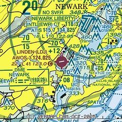
|
| Airport distance calculator |
|---|
|
|
| Sunrise and sunset |
|---|
|
Times for 01-Nov-2025
| | Local
(UTC-4) | | Zulu
(UTC) |
|---|
| Morning civil twilight | | 07:00 | | 11:00 |
| Sunrise | | 07:28 | | 11:28 |
| Sunset | | 17:53 | | 21:53 |
| Evening civil twilight | | 18:21 | | 22:21 |
|
| Current date and time |
|---|
| Zulu (UTC) | 01-Nov-2025 06:34:35 |
|---|
| Local (UTC-4) | 01-Nov-2025 02:34:35 |
|---|
|
| METAR |
|---|
| KLDJ | 010615Z AUTO 30017G22KT 10SM CLR 11/M02 A2973 RMK AO2 T01071016
|
KEWR
5nm NE | 010551Z 27015G40KT 10SM FEW060 12/M02 A2971 RMK AO2 PK WND 26040/0550 SLP059 T01171017 10133 20117 53030 $
|
KJRB
12nm NE | 010556Z AUTO VRB05KT 10SM CLR 12/01 A2971 RMK AO2 SLP061 T01170006 10133 20117 53032
|
KMMU
13nm NW | 010615Z AUTO 25010G18KT 10SM SCT060 09/M01 A2973 RMK AO2
|
KCDW
16nm N | 010553Z AUTO 31019G31KT 10SM CLR 11/M02 A2971 RMK AO2 PK WND 30032/0504 SLP065 T01111022 10128 20111 53029
|
KNYC
16nm NE | 010551Z AUTO 27013G25KT 10SM CLR 11/M03 A2972 RMK AO2 SLP056 T01111028 10128 20111 53034
|
KTEB
17nm NE | 010551Z 28015G35KT 10SM CLR 11/M02 A2969 RMK AO2 PK WND 27035/0544 SLP053 T01111022 10128 20111 53029 $
|
KLGA
19nm NE | 010551Z 29017G36KT 10SM FEW060 12/M03 A2968 RMK AO2 PK WND 28038/0536 SLP051 T01171033 10150 20117 53032 $
|
KSMQ
19nm W | ASOS 120.60 908-722-2139
010553Z AUTO 10SM FEW065 11/M01 A2972 RMK AO2 SLP064 T01061006 10128 20106 53026
|
|
| TAF |
|---|
KEWR
5nm NE | 010526Z 0106/0212 26020G28KT P6SM FEW060 FM010900 28013G23KT P6SM FEW050 FM011500 29017G28KT P6SM SCT060 FM012300 30009KT P6SM FEW060 BKN250
|
KTEB
17nm NE | 010526Z 0106/0212 26016G23KT P6SM SCT050 FM010900 29011G20KT P6SM FEW050 FM011500 30015G27KT P6SM SCT060 FM012300 31008KT P6SM FEW060 BKN250
|
KLGA
19nm NE | 010526Z 0106/0212 27022G30KT P6SM FEW060 FM010900 28015G25KT P6SM FEW050 FM011500 30017G28KT P6SM SCT060 FM012300 31009KT P6SM FEW060 BKN250
|
|
| NOTAMs |
|---|
NOTAMs are issued by the DoD/FAA and will open in a separate window not controlled by AirNav.
|
|


