FAA INFORMATION EFFECTIVE 09 JULY 2026
Location
| FAA Identifier: | TGI |
| Lat/Long: | 37-49-33.1150N 075-59-51.5850W
37-49.551917N 075-59.859750W
37.8258653,-75.9976625
(estimated) |
| Elevation: | 5.4 ft. / 1.6 m (surveyed) |
| Variation: | 11W (2010) |
| From city: | 1 mile W of TANGIER, VA |
| Time zone: | UTC -4 (UTC -5 during Standard Time) |
| Zip code: | 23440 |
Airport Operations
| Airport use: | Open to the public |
| Control tower: | no |
| ARTCC: | WASHINGTON CENTER |
| FSS: | LEESBURG FLIGHT SERVICE STATION |
| NOTAMs facility: | DCA (NOTAM-D service available) |
| Attendance: | APR-OCT SAT-SUN 0800-1630
ARPT CLSD SS-SR DLY. |
| Pattern altitude: | TPA LGT ACFT 600 FT HVY ACFT 1500 FT. |
| Wind indicator: | yes |
| Segmented circle: | no |
| Beacon: | white-green (lighted land airport)
ARPT BCN OTS INDEFLY. |
| Landing fee: | yes |
Airport Communications
| CTAF/UNICOM: | 122.8 |
| WX AWOS-3PT: | 119.8 (757-891-2496) |
| PATUXENT APPROACH: | 121.0 |
| POTOMAC APPROACH: | 127.2 ;WHEN NHK APCH CLSD |
| PATUXENT DEPARTURE: | 121.0 |
| POTOMAC DEPARTURE: | 127.2 ;WHEN NHK APCH CLSD |
| WX AWOS-3 at MFV (16 nm SE): | 118.175 (757-787-5660) |
- APCH/DEP SVC PRVDD BY POTOMAC TRACON ON 127.2/281.47 WHEN PATUXENT APCH CTL CLSD.
Airport Services
| Parking: | tiedowns |
| Airframe service: | NONE |
| Powerplant service: | NONE |
| Bottled oxygen: | NONE |
| Bulk oxygen: | NONE |
Runway Information
Runway 2/20
| Dimensions: | 2426 x 75 ft. / 739 x 23 m |
| Surface: | asphalt, in fair condition |
| Weight bearing capacity: | |
| Runway edge markings: | TWY LEAD-IN LINES POOR. RWY CENTERLINE POOR. |
| RUNWAY 2 | | RUNWAY 20 |
| Latitude: | 37-49.353500N | | 37-49.750333N |
| Longitude: | 075-59.890833W | | 075-59.828667W |
| Elevation: | 5.4 ft. | | 4.8 ft. |
| Traffic pattern: | right | | left |
| Runway heading: | 018 magnetic, 007 true | | 198 magnetic, 187 true |
| Displaced threshold: | no | | 183 ft. |
| Markings: | basic, in poor condition | | basic, in poor condition |
| Touchdown point: | yes, no lights | | yes, no lights |
| Obstructions: | 12 ft. tree, 219 ft. from runway, 91 ft. right of centerline, 1:1 slope to clear
BRUSH 70 FT LEFT & RIGHT RWY CNTRLN. | | 15 ft. road, 249 ft. from runway, 3:1 slope to clear
BRUSH 70 FT RIGHT & LEFT RWY CNTRLN. |
Airport Ownership and Management from official FAA records
| Ownership: | Publicly-owned |
| Owner: | TOWN OF TANGIER
TANGIER ISLAND
TANGIER, VA 23440
Phone 757-891-2496
TOWN OFFICE (757) 891-2438. |
| Manager: | LAURIE THOMAS
PO BOX 244
TANGIER, VA 23440
Phone 757-891-2496 |
Additional Remarks
| - | PAEW ADJACENT TO ALL RWYS, TWYS & RAMPS. |
| - | BE ALERT: RSTD AREA ONE MI WEST OF ARPT; HI-SPEED ACFT DROP BOMBS & FIRE LIVE AMMUNITION IN AREA. |
| - | LANDING/PARKING FEE TO HELP PAY FOR RECENT RWY REHAB. |
| - | FOR CD CTC PATUXENT APCH AT 301-342-3740, WHEN PATUXENT APCH IS CLSD CTC POTOMAC APCH AT 866-640-4124. |
Instrument Procedures
NOTE: All procedures below are presented as PDF files. If you need a reader for these files, you should download the free Adobe Reader.NOT FOR NAVIGATION. Please procure official charts for flight.
FAA instrument procedures published for use from 09 July 2026 at 0901Z to 06 August 2026 at 0900Z.
IAPs - Instrument Approach Procedures |
|---|
| RNAV (GPS)-B **CHANGED** | |
download (185KB) |
| NOTE: Special Alternate Minimums apply | |
download (166KB) |
| NOTE: Special Take-Off Minimums/Departure Procedures apply | |
download (140KB) |
Other nearby airports with instrument procedures:
W41 - Crisfield-Somerset County Airport (14 nm NE)
KMFV - Accomack County Airport (16 nm SE)
W75 - Hummel Field Airport (25 nm SW)
KWAL - Wallops Flight Facility (26 nm E)
KNHK - Patuxent River Naval Air Station (Trapnell Field) Airport (34 nm NW)
|
|

Road maps at:
MapQuest
Bing
Google
| Aerial photo |
|---|
WARNING: Photo may not be current or correct
 Photo by David Newcomer
Photo taken 20-Aug-2015
looking north from 3,000 MSL.
Photo by David Newcomer
Photo taken 20-Aug-2015
looking north from 3,000 MSL.
Do you have a better or more recent aerial photo of Tangier Island Airport that you would like to share? If so, please send us your photo.
|
| Sectional chart |
|---|
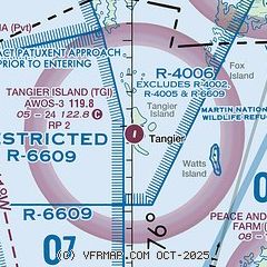
|
| Airport distance calculator |
|---|
|
|
| Sunrise and sunset |
|---|
|
Times for 31-Jul-2026
| | Local
(UTC-4) | | Zulu
(UTC) |
|---|
| Morning civil twilight | | 05:38 | | 09:38 |
| Sunrise | | 06:07 | | 10:07 |
| Sunset | | 20:13 | | 00:13 |
| Evening civil twilight | | 20:42 | | 00:42 |
|
| Current date and time |
|---|
| Zulu (UTC) | 31-Jul-2026 20:21:23 |
|---|
| Local (UTC-4) | 31-Jul-2026 16:21:23 |
|---|
|
| METAR |
|---|
KMFV
16nm SE | 311955Z AUTO 35003KT 10SM CLR 28/17 A2997 RMK AO2 T02810170
|
|
| TAF |
|---|
KNHK
33nm NW | 311400Z 3115/0115 VRB06KT 9999 SCT035 SCT080 522709 QNH2994INS BECMG 3117/3118 08006KT 9999 SCT040 522709 QNH2992INS TEMPO 3117/3120 BKN040 BECMG 3120/3121 13006KT 9999 FEW050 SCT250 522709 QNH2993INS BECMG 0100/0101 18006KT 9999 SCT050 BKN250 500000 QNH2993INS TX28/3120Z TN20/0110Z FN20119
|
KSBY
38nm NE | 311723Z 3118/0118 28005KT P6SM SCT040 FM312000 19006KT P6SM FEW045 FM010000 VRB02KT P6SM SKC FM011400 20007KT P6SM SCT045
|
|
| NOTAMs |
|---|
NOTAMs are issued by the DoD/FAA and will open in a separate window not controlled by AirNav.
|
|

