FAA INFORMATION EFFECTIVE 02 OCTOBER 2025
Location
| FAA Identifier: | MU97 |
| Lat/Long: | 39-12-35.6000N 093-55-39.8000W
39-12.593333N 093-55.663333W
39.2098889,-93.9277222
(estimated) |
| Elevation: | 691 ft. / 210.6 m (surveyed) |
| Variation: | 04E (1985) |
| From city: | 3 miles NW of LEXINGTON, MO |
| Time zone: | UTC -5 (UTC -6 during Standard Time) |
| Zip code: | 64036 |
Airport Operations
| Airport use: | Private use. Permission required prior to landing |
| Activation date: | 12/1945 |
| Control tower: | no |
| ARTCC: | KANSAS CITY CENTER |
| FSS: | COLUMBIA FLIGHT SERVICE STATION |
| Attendance: | IRREGULAR 24 HOURS/DAY |
| Wind indicator: | yes |
| Segmented circle: | no |
Airport Communications
| CTAF/UNICOM: | 122.7 |
| WX AWOS-3P at GPH (19 nm NW): | 120.275 (816-407-3399) |
- APCH/DEP SVC PRVDD BY KANSAS CITY ARTCC ON FREQS 135.575/323.15 (KNOB NOSTER RCAG).
Nearby radio navigation aids
| VOR radial/distance | | VOR name | | Freq | | Var |
|---|
| ANXr047/11.6 | | NAPOLEON VORTAC | | 115.15 | | 07E |
| BQSr183/25.4 | | BRAYMER VOR/DME | | 115.35 | | 03E |
| MCIr092/37.9 | | KANSAS CITY VORTAC | | 113.25 | | 05E |
Airport Services
| Parking: | hangars and tiedowns |
| Bottled oxygen: | NONE |
| Bulk oxygen: | NONE |
Runway Information
Runway 4/22
| Dimensions: | 2925 x 40 ft. / 892 x 12 m |
| Surface: | asphalt, in fair condition
RWY 04/22 ROUGH, LARGE PITS IN SFC, CRACKS. |
| RUNWAY 4 | | RUNWAY 22 |
| Latitude: | 39-12.414867N | | 39-12.770117N |
| Longitude: | 093-55.818150W | | 093-55.399750W |
| Elevation: | 691.0 ft. | | 689.0 ft. |
| Traffic pattern: | left | | left |
| Runway heading: | 038 magnetic, 042 true | | 218 magnetic, 222 true |
| Touchdown point: | yes, no lights | | no, no lights |
| Obstructions: | 14 ft. road, 325 ft. from runway, 130 ft. left and right of centerline, 8:1 slope to clear | | none |
Runway 13/31
| Dimensions: | 3100 x 125 ft. / 945 x 38 m |
| Surface: | turf, in excellent condition |
| RUNWAY 13 | | RUNWAY 31 |
| Latitude: | 39-12.784217N | | 39-12.415330N |
| Longitude: | 093-55.819643W | | 093-55.365503W |
| Elevation: | 690.0 ft. | | 690.0 ft. |
| Traffic pattern: | left | | left |
| Runway heading: | 132 magnetic, 136 true | | 312 magnetic, 316 true |
| Obstructions: | 29 ft. pline, marked, 330 ft. from runway, 150 ft. left and right of centerline, 11:1 slope to clear | | 15 ft. road, 270 ft. from runway, 140 ft. left and right of centerline, 18:1 slope to clear |
Runway 18/36
| Dimensions: | 2250 x 125 ft. / 686 x 38 m |
| Surface: | turf, in excellent condition |
| RUNWAY 18 | | RUNWAY 36 |
| Latitude: | 39-12.769533N | | 39-12.398467N |
| Longitude: | 093-55.829917W | | 093-55.829917W |
| Elevation: | 690.0 ft. | | 690.0 ft. |
| Traffic pattern: | left | | left |
| Runway heading: | 176 magnetic, 180 true | | 356 magnetic, 000 true |
| Obstructions: | none | | 15 ft. road, 227 ft. from runway, 15:1 slope to clear |
Airport Ownership and Management from official FAA records
| Ownership: | Privately-owned |
| Owner: | DAVID EDWARDS
11215 GREAT CANADIAN LANE
RICHMOND, MO 64085
Phone (816) 752-5333 |
| Manager: | DAVID EDWARDS
11215 GREAT CANADIAN LANE
RICHMOND, MO 64085
Phone (816) 752-5333 |
Additional Remarks
| A96 | ULTRALIGHT ACTIVITY & RADIO CONTROLLED AIRPLANES ON & INVOF ARPT. |
| - | MIGRATORY BIRDS INVOF ARPT DURING SPRING AND FALL. |
| - | NTSD RWY SAFETY AREA RWY22; INCORRECT TERRAIN GRADES. |
| - | FOR CD CTC KANSAS CITY ARTCC AT 913-254-8508. |
Instrument Procedures
There are no published instrument procedures at MU97.
Some nearby airports with instrument procedures:
KHIG - Higginsville Industrial Municipal Airport (14 nm SE)
3EX - Excelsior Springs Memorial Airport (15 nm NW)
3GV - East Kansas City Airport (18 nm SW)
KGPH - Midwest National Air Center Airport (19 nm NW)
KLXT - Kansas City/Lee's Summit Regional Airport (26 nm SW)
|
|

Road maps at:
MapQuest
Bing
Google
| Aerial photo |
|---|
WARNING: Photo may not be current or correct

Do you have a better or more recent aerial photo of Lexington Municipal Airport that you would like to share? If so, please send us your photo.
|
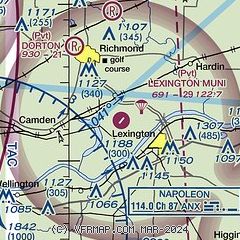
| Sectional chart |
|---|
|
| Airport distance calculator |
|---|
|
|
| Sunrise and sunset |
|---|
|
Times for 10-Oct-2025
| | Local
(UTC-5) | | Zulu
(UTC) |
|---|
| Morning civil twilight | | 06:55 | | 11:55 |
| Sunrise | | 07:21 | | 12:21 |
| Sunset | | 18:44 | | 23:44 |
| Evening civil twilight | | 19:11 | | 00:11 |
|
| Current date and time |
|---|
| Zulu (UTC) | 10-Oct-2025 05:39:20 |
|---|
| Local (UTC-5) | 10-Oct-2025 00:39:20 |
|---|
|
| METAR |
|---|
KGPH
19nm NW | 100515Z AUTO 00000KT 10SM CLR 16/08 A3024 RMK AO2
|
KLXT
25nm SW | 100453Z AUTO 16009KT 10SM CLR 18/09 A3024 RMK AO2 SLP234 T01780089 $
|
KRCM
26nm S | 100515Z AUTO 17004KT 10SM CLR 15/08 A3025 RMK AO2
|
KMKC
32nm W | 100454Z 13006KT 10SM CLR 19/09 A3022 RMK AO2 SLP227 T01940094
|
KMHL
34nm E | 100515Z AUTO 00000KT 10SM CLR 13/08 A3026 RMK AO2
|
KSZL
35nm SE | 100455Z 17006KT 10SM CLR 16/08 A3025 RMK AO2A SLP242 T01640084 VISNO RWY01 CHINO RWY01 $
|
KEZZ
35nm NW | 100515Z AUTO 15006KT 10SM CLR 15/10 A3027 RMK AO2
|
KGVW
37nm SW | 100515Z AUTO 8SM CLR 29/20 A3011 RMK A01
|
KMCI
38nm W | 100453Z 15009KT 10SM CLR 18/09 A3022 RMK AO2 SLP227 T01830094
|
|
| TAF |
|---|
KMKC
32nm W | 091720Z 0918/1018 16011KT P6SM BKN035 FM100100 16007KT P6SM FEW060 PROB30 1009/1014 5SM -TSRA SCT050CB OVC100 FM101500 21007KT P6SM SCT200
|
KSZL
35nm SE | 100300Z 1003/1109 14006KT 9999 FEW060 QNH3024INS BECMG 1007/1008 18006KT 9999 BKN060 QNH3021INS BECMG 1009/1010 18009KT 8000 -SHRA OVC030 QNH3021INS TEMPO 1011/1014 19010G15KT 4800 -TSRA OVC020CB BECMG 1013/1014 20009KT 9999 NSW FEW015 OVC030 QNH3011INS BECMG 1022/1023 VRB06KT 9999 BKN050 QNH3011INS BECMG 1107/1108 04006KT 4800 BR BKN010 QNH3012INS TX27/1021Z TN15/1011Z
|
KMCI
38nm W | 091720Z 0918/1018 16011G18KT P6SM SCT025 BKN090 FM092000 16011G18KT P6SM SCT030 SCT090 FM100100 15009KT P6SM FEW060 FM100900 18010KT P6SM BKN060 PROB30 1009/1013 5SM -TSRA BKN050CB OVC100
|
|
| NOTAMs |
|---|
NOTAMs are issued by the DoD/FAA and will open in a separate window not controlled by AirNav.
|
|

