FAA INFORMATION EFFECTIVE 19 FEBRUARY 2026
Location
| FAA Identifier: | O88 |
| Lat/Long: | 38-11-36.2000N 121-42-13.1000W
38-11.603333N 121-42.218333W
38.1933889,-121.7036389
(estimated) |
| Elevation: | 22.6 ft. / 7 m (estimated) |
| Variation: | 14E (2010) |
| From city: | 3 miles NW of RIO VISTA, CA |
| Time zone: | UTC -8 (UTC -7 during Daylight Saving Time) |
| Zip code: | 94571 |
Airport Operations
| Airport use: | Open to the public |
| Activation date: | 05/1994 |
| Control tower: | no |
| ARTCC: | OAKLAND CENTER |
| FSS: | RANCHO MURIETA FLIGHT SERVICE STATION |
| NOTAMs facility: | RIU (NOTAM-D service available) |
| Attendance: | MON-THUR 0800 - 1700 |
| Wind indicator: | lighted |
| Segmented circle: | yes |
| Lights: | ACTVT REIL RWY 07, 15, 25, & 33; PAPI RWY 07, 15, 25, & 33; MIRL RWY 07/25 & 15/33; PERIMETER H1 - CTAF. |
| Beacon: | white-green (lighted land airport)
Operates sunset to sunrise. |
Airport Communications
| CTAF/UNICOM: | 122.725 |
| WX AWOS-AV: | 127.075 (707-374-5396) |
| TRAVIS APPROACH: | 119.9 |
| TRAVIS DEPARTURE: | 119.9 |
| WX ASOS at VCB (16 nm NW): | 134.75 (707-240-8032) |
Nearby radio navigation aids
| VOR radial/distance | | VOR name | | Freq | | Var |
|---|
| SACr188/16.6 | | SACRAMENTO VORTAC | | 115.20 | | 17E |
| CCRr044/18.4 | | CONCORD VOR/DME | | 117.00 | | 17E |
| SGDr071/31.6 | | SCAGGS ISLAND VORTAC | | 112.10 | | 17E |
| MCCr189/31.7 | | MC CLELLAN VOR/DME | | 109.20 | | 17E |
| LINr265/33.8 | | LINDEN VOR/DME | | 114.80 | | 17E |
| OAKr024/37.3 | | OAKLAND VOR/DME | | 116.80 | | 17E |
Airport Services
| Fuel available: | 100LL
100LL:FAST PAY FUEL SYSTEM AVBL 24 HRS. |
| Parking: | tiedowns |
Runway Information
Runway 7/25
| Dimensions: | 4199 x 75 ft. / 1280 x 23 m |
| Surface: | asphalt, in good condition |
| Weight bearing capacity: | |
| Runway edge lights: | medium intensity |
| RUNWAY 7 | | RUNWAY 25 |
| Latitude: | 38-11.606865N | | 38-11.658582N |
| Longitude: | 121-42.573408W | | 121-41.699158W |
| Elevation: | 21.3 ft. | | 21.6 ft. |
| Traffic pattern: | left | | right |
| Runway heading: | 072 magnetic, 086 true | | 252 magnetic, 266 true |
| Markings: | nonprecision, in good condition | | nonprecision, in good condition |
| Visual slope indicator: | 2-light PAPI on left (4.00 degrees glide path) | | 2-light PAPI on left (4.00 degrees glide path) |
| Runway end identifier lights: | yes | | yes |
| Touchdown point: | yes, no lights | | yes, no lights |
Runway 15/33
| Dimensions: | 2199 x 60 ft. / 670 x 18 m |
| Surface: | asphalt, in good condition |
| Weight bearing capacity: | |
| Runway edge lights: | medium intensity |
| RUNWAY 15 | | RUNWAY 33 |
| Latitude: | 38-11.716400N | | 38-11.375910N |
| Longitude: | 121-42.452610W | | 121-42.295648W |
| Elevation: | 21.6 ft. | | 21.5 ft. |
| Traffic pattern: | left | | right |
| Runway heading: | 146 magnetic, 160 true | | 326 magnetic, 340 true |
| Markings: | nonprecision, in good condition | | nonprecision, in good condition |
| Visual slope indicator: | 2-light PAPI on left (4.00 degrees glide path) | | 2-light PAPI on left (4.00 degrees glide path) |
| Runway end identifier lights: | yes | | yes |
| Touchdown point: | yes, no lights | | yes, no lights |
| Obstructions: | 25 ft. pole, 1365 ft. from runway, 46:1 slope to clear | | none |
Helipad H1
| Dimensions: | 180 x 180 ft. / 55 x 55 m |
| Surface: | concrete |
| Runway edge lights: | PERI |
| Traffic pattern: | left | | left |
Airport Ownership and Management from official FAA records
| Ownership: | Publicly-owned |
| Owner: | CITY OF RIO VISTA
ONE MAIN STREET
RIO VISTA, CA 94571
Phone 707-374-6451 |
| Manager: | TOM HAVENS
ONE MAIN STREET, P.O. BOX 94571
RIO VISTA, CA 94571
Phone 707-249-7510
AFTER HOURS CALL (707) 249-7510 |
Additional Remarks
| - | RY 25 CALM WIND RY. |
| - | NOISE SENSITIVE AREA N OF RY 33. DO NOT OVERFLY RANCH & CORRALS OFF RY 33. ALL RYS CLIMB TO 700 FT BEFORE TURNS. |
| - | HELIPAD: NO AUTOROTATIONS HOVERING AUTO'S OR RUNNING LDGS TO PAVEMENT. |
| - | HEL TFC TO HELIPAD REMAIN SOUTH OF ARPT 500 FT. |
| - | WHEN WIND FAVORS RWY 15/33 HELS MAY USE APRON AREA WEST OF RWY 15/33; REMAIN WEST OF ARPT 500 FT. |
| - | FOR CD CTC OAKLAND ARTCC AT 510-745-3380. |
Instrument Procedures
NOTE: All procedures below are presented as PDF files. If you need a reader for these files, you should download the free Adobe Reader.NOT FOR NAVIGATION. Please procure official charts for flight.
FAA instrument procedures published for use from 19 February 2026 at 0901Z to 19 March 2026 at 0900Z.
IAPs - Instrument Approach Procedures |
|---|
| RNAV (GPS) RWY 25 | |
download (214KB) |
| NOTE: Special Take-Off Minimums/Departure Procedures apply | |
download (366KB) |
Other nearby airports with instrument procedures:
KSUU - Travis Air Force Base (11 nm W)
KVCB - Nut Tree Airport (16 nm NW)
1O3 - Lodi Airport (20 nm E)
KEDU - University Airport (21 nm N)
KCCR - Buchanan Field Airport (21 nm SW)
|
|

Road maps at:
MapQuest
Bing
Google
| Aerial photo |
|---|
WARNING: Photo may not be current or correct
 Photo by James M. Malone III, MD
Photo taken 03-Apr-2011
looking west.
Photo by James M. Malone III, MD
Photo taken 03-Apr-2011
looking west.
Do you have a better or more recent aerial photo of Rio Vista Municipal Airport that you would like to share? If so, please send us your photo.
|
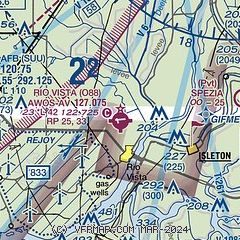
| Sectional chart |
|---|
|
| Airport distance calculator |
|---|
|
|
| Sunrise and sunset |
|---|
|
Times for 16-Mar-2026
| | Local
(UTC-7) | | Zulu
(UTC) |
|---|
| Morning civil twilight | | 06:51 | | 13:51 |
| Sunrise | | 07:17 | | 14:17 |
| Sunset | | 19:14 | | 02:14 |
| Evening civil twilight | | 19:40 | | 02:40 |
|
| Current date and time |
|---|
| Zulu (UTC) | 16-Mar-2026 16:19:22 |
|---|
| Local (UTC-7) | 16-Mar-2026 09:19:22 |
|---|
|
| METAR |
|---|
KSUU
11nm NW | 161555Z AUTO 00000KT 10SM CLR 15/10 A3007 RMK AO2 SLP189 T01490101 $
|
KVCB
16nm NW | 161553Z AUTO 00000KT 10SM CLR 16/10 A3010 RMK AO2 SLP191 T01610100 TSNO
|
KCCR
20nm SW | 161553Z 00000KT 10SM CLR 16/07 A3009 RMK AO2 SLP176 T01560072
|
KEDU
21nm N | 161550Z AUTO 00000KT 10SM CLR 15/10 A3010 RMK AO1
|
KSAC
21nm NE | 161553Z 12003KT 10SM CLR 15/10 A3009 RMK AO2 SLP190 T01500100
|
|
| TAF |
|---|
KSUU
11nm NW | 161100Z 1611/1717 VRB06KT 9999 SKC QNH2996INS TX29/1623Z TN10/1614Z
|
|
| NOTAMs |
|---|
NOTAMs are issued by the DoD/FAA and will open in a separate window not controlled by AirNav.
|
|

