FAA INFORMATION EFFECTIVE 27 NOVEMBER 2025
Location
| FAA Identifier: | VRB |
| Lat/Long: | 27-39-19.9980N 080-25-04.6350W
27-39.333300N 080-25.077250W
27.6555550,-80.4179542
(estimated) |
| Elevation: | 23.7 ft. / 7.2 m (surveyed) |
| Variation: | 07W (2015) |
| From city: | 1 mile NW of VERO BEACH, FL |
| Time zone: | UTC -5 (UTC -4 during Daylight Saving Time) |
| Zip code: | 32960 |
Airport Operations
| Airport use: | Open to the public |
| Activation date: | 04/1940 |
| Control tower: | yes |
| ARTCC: | MIAMI CENTER |
| FSS: | SAINT PETERSBURG FLIGHT SERVICE STATION |
| NOTAMs facility: | VRB (NOTAM-D service available) |
| Attendance: | 0600-2300 |
| Wind indicator: | lighted |
| Segmented circle: | yes |
| Lights: | WHEN ATCT CLSD, ACTVT REIL RWY 04, 12R, 22 & 30L; PAPI RWY 4, 12R, 12L, 22, 30R & 30L; MIRL RWY 4/22, 12R/30L, 12L/30R - CTAF |
| Beacon: | white-green (lighted land airport)
Operates sunset to sunrise. |
| Fire and rescue: | ARFF index B |
| Airline operations: | CLSD TO UNSKED ACR OPS WITH MORE THAN 30 PAX SEATS; 24 HR PPR REQ - AMGR. |
Airport Communications
| CTAF: | 126.3 |
| UNICOM: | 122.95 |
| ATIS: | 120.575 |
| WX ASOS: | 120.575 (772-978-9535) |
| VERO BEACH GROUND: | 127.45 [0700-0100] |
| VERO BEACH TOWER: | 126.3 133.15 [0700-0100] |
| PALM BEACH APPROACH: | 123.625 ;NORTH |
| PALM BEACH DEPARTURE: | 123.625 ;NORTH |
| CLEARANCE DELIVERY: | 134.975 |
| WX ASOS at FPR (10 nm S): | PHONE 772-489-4281 |
| WX AWOS-3PT at X26 (10 nm NW): | 118.125 (772-228-7020) |
| WX AWOS-3PT at X59 (20 nm N): | 119.525 |
Nearby radio navigation aids
| VOR radial/distance | | VOR name | | Freq | | Var |
|---|
| MLBr164/29.3 | | MELBOURNE VOR/DME | | 115.85 | | 07W |
Airport Services
| Fuel available: | 100 JET-A |
| Parking: | hangars and tiedowns |
| Airframe service: | MAJOR |
| Powerplant service: | MAJOR |
| Bottled oxygen: | HIGH/LOW |
| Bulk oxygen: | NONE |
Runway Information
Runway 12R/30L
| Dimensions: | 7314 x 100 ft. / 2229 x 30 m |
| Surface: | asphalt/grooved, in excellent condition |
| Weight bearing capacity: | | Single wheel: | 85.0 | | Double wheel: | 115.0 | | Double tandem: | 220.0 |
|
| Runway edge lights: | medium intensity |
| RUNWAY 12R | | RUNWAY 30L |
| Latitude: | 27-39.471572N | | 27-39.046685N |
| Longitude: | 080-25.717150W | | 080-24.448387W |
| Elevation: | 23.3 ft. | | 20.1 ft. |
| Traffic pattern: | right | | left |
| Runway heading: | 118 magnetic, 111 true | | 298 magnetic, 291 true |
| Declared distances: | TORA:7314 TODA:7314 ASDA:7314 LDA:7314 | | TORA:7314 TODA:7314 ASDA:7276 LDA:7276 |
| Markings: | precision, in good condition | | nonprecision, in good condition |
| Visual slope indicator: | 4-light PAPI on left (3.00 degrees glide path) | | 4-light PAPI on left (3.00 degrees glide path) |
| Runway end identifier lights: | yes | | yes |
| Touchdown point: | yes, no lights | | yes, no lights |
| Obstructions: | 66 ft. trees, 2790 ft. from runway, 30 ft. left of centerline, 39:1 slope to clear | | 40 ft. trees, 1965 ft. from runway, 315 ft. right of centerline, 44:1 slope to clear |
Runway 4/22
| Dimensions: | 4974 x 100 ft. / 1516 x 30 m |
| Surface: | asphalt/grooved, in good condition |
| Weight bearing capacity: | | Single wheel: | 30.0 | | Double wheel: | 115.0 | | Double tandem: | 220.0 |
|
| Runway edge lights: | medium intensity |
| Operational restrictions: | RWY 04/22 NOT AVBL FOR PART 121/PART 380 OPS WITH SKED PAX CARRYING OPS MORE THAN 9 PAX SEATS AND NON-SKED PAX CARRYING OPS MORE THAN 30 PAX SEATS. |
| RUNWAY 4 | | RUNWAY 22 |
| Latitude: | 27-38.979560N | | 27-39.642038N |
| Longitude: | 080-25.599600W | | 080-25.055350W |
| Elevation: | 23.4 ft. | | 20.6 ft. |
| Traffic pattern: | left | | left |
| Runway heading: | 043 magnetic, 036 true | | 223 magnetic, 216 true |
| Declared distances: | TORA:4974 TODA:4974 ASDA:4974 LDA:4974 | | TORA:4974 TODA:4974 ASDA:4945 LDA:4945 |
| Markings: | nonprecision, in good condition | | nonprecision, in good condition |
| Visual slope indicator: | 4-light PAPI on left (3.00 degrees glide path) | | 4-light PAPI on left (3.00 degrees glide path) |
| Runway end identifier lights: | yes | | yes |
| Touchdown point: | yes, no lights | | yes, no lights |
| Obstructions: | 35 ft. trees, 1395 ft. from runway, 250 ft. right of centerline, 34:1 slope to clear | | 55 ft. trees, 2070 ft. from runway, 80 ft. left of centerline, 34:1 slope to clear |
Runway 12L/30R
| Dimensions: | 3505 x 75 ft. / 1068 x 23 m |
| Surface: | asphalt, in fair condition |
| Weight bearing capacity: | |
| Runway edge lights: | medium intensity |
| Operational restrictions: | RWY 12L/30R NOT AVBL FOR PART 121/PART 380 OPS WITH SKED PAX CARRYING OPS MORE THAN 9 PAX SEATS AND NON-SKED PAX CARRYING OPS MORE THAN 30 PAX SEATS. |
| RUNWAY 12L | | RUNWAY 30R |
| Latitude: | 27-39.623050N | | 27-39.416997N |
| Longitude: | 080-25.013920W | | 080-24.407140W |
| Elevation: | 19.5 ft. | | 19.6 ft. |
| Traffic pattern: | left | | right |
| Runway heading: | 118 magnetic, 111 true | | 298 magnetic, 291 true |
| Declared distances: | TORA:3505 TODA:3505 ASDA:3505 LDA:3505 | | TORA:3505 TODA:3505 ASDA:3505 LDA:3505 |
| Markings: | basic, in fair condition | | basic, in fair condition |
| Visual slope indicator: | 2-light PAPI on left (3.00 degrees glide path) | | 2-light PAPI on left (3.50 degrees glide path) |
| Touchdown point: | yes, no lights | | yes, no lights |
| Obstructions: | 51 ft. trees, 1630 ft. from runway, 135 ft. right of centerline, 28:1 slope to clear | | 35 ft. trees, 1120 ft. from runway, 80 ft. right of centerline, 26:1 slope to clear |
Airport Ownership and Management from official FAA records
| Ownership: | Publicly-owned |
| Owner: | CITY OF VERO BEACH
PO BOX 1389
VERO BEACH, FL 32960
Phone 772-978-5151 |
| Manager: | TODD SCHER
3400 CHEROKEE DRIVE
VERO BEACH, FL 32960-1389
Phone 772-978-4930
EXT 104. |
Additional Remarks
| A39-12L/30R | PCR VALUE: 150/F/B/X/T |
| A39-04/22 | PCR VALUE: 350/F/A/X/T |
| A39-12R/30L | PCR VALUE: 450/F/B/X/T |
| - | FLT TRNG ON & INVOF ARPT. |
| - | TWY B & F OPS FOR ACFT WITH WINGSPAN OF MORE THAN 79 FT AT PILOTS DISCRETION - AMGR. |
| - | GLDR OPS INVOF X52 ARPT APRXLY 8 NM WSW. |
| - | NOISE SENSITIVE ARPT; JET ACFT USE NATL BUS ACFT ASSOCIATION NOISE ABATEMENT PROC. |
| - | VOLUNTARY LOCAL NOISE ABATEMENT PROC IN EFCT - AMGR. |
| - | INT DEP NA EXC BY ATC REQUEST. |
| - | RSCD NOT MNT 2300-0600 M-F 1530-0600 WKEND AND HOL. |
| - | FOR CD IF UNA TO CTC ON FSS FREQ, CTC PALM BEACH APCH AT 561-275-1430. |
Instrument Procedures
NOTE: All procedures below are presented as PDF files. If you need a reader for these files, you should download the free Adobe Reader.NOT FOR NAVIGATION. Please procure official charts for flight.
FAA instrument procedures published for use from 27 November 2025 at 0901Z to 25 December 2025 at 0900Z.
IAPs - Instrument Approach Procedures |
|---|
| RNAV (GPS) RWY 04 | |
download (271KB) |
| RNAV (GPS) RWY 12R | |
download (271KB) |
| RNAV (GPS) RWY 22 | |
download (275KB) |
| RNAV (GPS) RWY 30L | |
download (278KB) |
| NOTE: Special Alternate Minimums apply | |
download (149KB) |
| NOTE: Special Take-Off Minimums/Departure Procedures apply | |
download (588KB) |
Other nearby airports with instrument procedures:
KFPR - Treasure Coast International Airport (10 nm S)
X26 - Sebastian Municipal Airport (10 nm NW)
X59 - Valkaria Airport (20 nm N)
KMLB - Melbourne Orlando International Airport (29 nm NW)
KSUA - Witham Field Airport (30 nm S)
|
|

Road maps at:
MapQuest
Bing
Google
| Aerial photo |
|---|
WARNING: Photo may not be current or correct
 Photo taken 31-Mar-2015
looking west at 3,000 ft
Photo taken 31-Mar-2015
looking west at 3,000 ft
Do you have a better or more recent aerial photo of Vero Beach Regional Airport that you would like to share? If so, please send us your photo.
|
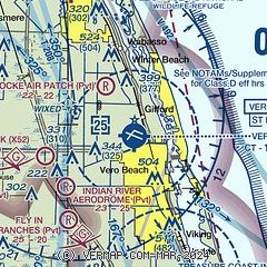
| Sectional chart |
|---|
|
CAUTION: Diagram may not be current
 Download PDF
of official airport diagram from the FAA
| Airport distance calculator |
|---|
|
|
| Sunrise and sunset |
|---|
|
Times for 02-Dec-2025
| | Local
(UTC-5) | | Zulu
(UTC) |
|---|
| Morning civil twilight | | 06:31 | | 11:31 |
| Sunrise | | 06:57 | | 11:57 |
| Sunset | | 17:25 | | 22:25 |
| Evening civil twilight | | 17:51 | | 22:51 |
|
| Current date and time |
|---|
| Zulu (UTC) | 02-Dec-2025 11:18:54 |
|---|
| Local (UTC-5) | 02-Dec-2025 06:18:54 |
|---|
|
| METAR |
|---|
| KVRB | 021053Z AUTO 18007KT 10SM CLR 21/21 A2994 RMK AO2 SLP137 T02110206
|
KFPR
10nm S | 021053Z AUTO 18006KT 10SM CLR 21/21 A2994 RMK AO2 SLP138 T02110206
|
KX26
10nm NW | 021055Z AUTO 18004KT 10SM CLR 20/20 A2992 RMK AO2
|
|
| TAF |
|---|
| KVRB | 020745Z 0208/0306 VRB05KT P6SM FEW025 SCT120 TEMPO 0208/0211 1SM BR FM021300 20012G18KT P6SM FEW008 FEW015 SCT100 FM021600 22017G25KT P6SM SCT025 BKN060 FM021900 24015G22KT P6SM VCSH SCT040 SCT150 FM030000 25005KT P6SM SCT030 SCT140 BKN250
|
KFPR
10nm S | 020520Z 0206/0306 VRB05KT P6SM FEW025 SCT120 FM021300 20012G18KT P6SM FEW008 FEW015 SCT100 FM021600 22014G24KT P6SM SCT025 BKN060 FM021900 24014G22KT P6SM VCSH SCT040 SCT150 FM030000 26004KT P6SM SCT030 SCT140 BKN250
|
|
| NOTAMs |
|---|
NOTAMs are issued by the DoD/FAA and will open in a separate window not controlled by AirNav.
|
|


