FAA INFORMATION EFFECTIVE 02 OCTOBER 2025
Location
| FAA Identifier: | W40 |
| Lat/Long: | 35-13-17.2350N 078-02-19.0200W
35-13.287250N 078-02.317000W
35.2214542,-78.0386167
(estimated) |
| Elevation: | 166.7 ft. / 50.8 m (surveyed) |
| Variation: | 09W (2015) |
| From city: | 3 miles NE of MOUNT OLIVE, NC |
| Time zone: | UTC -4 (UTC -5 during Standard Time) |
| Zip code: | 28365 |
Airport Operations
| Airport use: | Open to the public |
| Control tower: | no |
| ARTCC: | WASHINGTON CENTER |
| FSS: | RALEIGH FLIGHT SERVICE STATION |
| NOTAMs facility: | RDU (NOTAM-D service available) |
| Attendance: | 0800-1800
UNATNDD ON MAJOR HOLS. FOR SVC AFTER HRS CALL 252-234-7778 OR 252-289-7778. |
| Wind indicator: | lighted |
| Segmented circle: | yes |
| Lights: | AFTER SS ACTVT AND INCR INTST MIRL RWY 05/23 - CTAF. ACTVT PAPI RWY 05 & 23 - CTAF. |
| Beacon: | white-green (lighted land airport)
Operates sunset to sunrise. |
Airport Communications
| CTAF/UNICOM: | 122.8 |
| WX AWOS-3P: | 120.075 (919-658-8067) |
| SEYMOUR JOHNSON APPROACH: | 119.7 |
| SEYMOUR JOHNSON DEPARTURE: | 119.7 |
| WX AWOS-3PT at GSB (8 nm NE): | 317.625 |
| WX AWOS-3 at DPL (14 nm S): | 120.675 (910-296-9688) |
| WX AWOS-3P at GWW (15 nm N): | 118.975 (919-731-4473) |
- APCH/DEP SVC PRVDD BY WASHINGTON ARTCC (ZDC) ON 123.85/279.65 (NEW BERN RCAG) WHEN APCH CTL CLSD.
Nearby radio navigation aids
| VOR radial/distance | | VOR name | | Freq | | Var |
|---|
| ISOr254/25.2 | | KINSTON VORTAC | | 117.50 | | 05W |
| NDB name | | Hdg/Dist | | Freq | | Var | | ID |
|---|
| CLINTON | | 056/21.7 | | 412 | | 09W | | CTZ | -.-. - --.. |
| HARNETT | | 120/33.6 | | 417 | | 08W | | HQT | .... --.- - |
Airport Services
| Fuel available: | 100LL JET-A1+
100LL:FOR AVGAS AND JET A - 24 HR SELF SVC WITH CREDIT CARD. |
| Parking: | hangars and tiedowns |
| Airframe service: | MAJOR |
| Powerplant service: | MAJOR |
| Bottled oxygen: | HIGH/LOW |
| Bulk oxygen: | NONE |
Runway Information
Runway 5/23
| Dimensions: | 5254 x 75 ft. / 1601 x 23 m |
| Surface: | asphalt, in good condition |
| Weight bearing capacity: | |
| Runway edge lights: | medium intensity |
| RUNWAY 5 | | RUNWAY 23 |
| Latitude: | 35-12.956978N | | 35-13.617505N |
| Longitude: | 078-02.658345W | | 078-01.975605W |
| Elevation: | 166.2 ft. | | 166.5 ft. |
| Traffic pattern: | left | | left |
| Runway heading: | 049 magnetic, 040 true | | 229 magnetic, 220 true |
| Displaced threshold: | no | | 254 ft. |
| Markings: | nonprecision, in fair condition | | nonprecision, in fair condition |
| Visual slope indicator: | 2-light PAPI on left (3.50 degrees glide path) | | 2-light PAPI on left (3.50 degrees glide path) |
| Touchdown point: | yes, no lights | | yes, no lights |
| Obstructions: | 65 ft. trees, 2005 ft. from runway, 81 ft. right of centerline, 27:1 slope to clear | | 19 ft. road, 279 ft. from runway, 96 ft. left of centerline, 4:1 slope to clear
APCH SLOPE 20:1 TO DSPLCD THR. |
Airport Ownership and Management from official FAA records
| Ownership: | Publicly-owned |
| Owner: | TOWN OF MT OLIVE AND WAYNE COUNTY
114 EAST JAMES STREET
MT OLIVE, NC 28365
Phone 919-635-9539 |
| Manager: | MICHAEL BASS
227 MT OLIVE AIRPORT ROAD
MT OLIVE, NC 28365
Phone 919-635-1471 |
Additional Remarks
| - | RWY 05 +200 FT AM RADIO TWR APPROX 6000 FT SW OF RWY END ON CNTRLN. |
| - | LOW-LEVEL MIL ACT NEAR ARPT. |
| - | -5 FT DRAINAGE DITCH 100 FT LEFT OF CNTRLN OF RWY 05. |
| - | FOR COLLISION AVOIDANCE CONTACT SEYMOUR AFB 119.7. |
| - | FOR CD CTC WASHINGTON ARTCC AT 703-771-3587. |
Instrument Procedures
NOTE: All procedures below are presented as PDF files. If you need a reader for these files, you should download the free Adobe Reader.NOT FOR NAVIGATION. Please procure official charts for flight.
FAA instrument procedures published for use from 02 October 2025 at 0901Z to 30 October 2025 at 0900z.
IAPs - Instrument Approach Procedures |
|---|
| RNAV (GPS) RWY 05 | |
download (206KB) |
| RNAV (GPS) RWY 23 | |
download (187KB) |
| NOTE: Special Alternate Minimums apply | |
download (167KB) |
| NOTE: Special Take-Off Minimums/Departure Procedures apply | |
download (141KB) |
Other nearby airports with instrument procedures:
KGSB - Seymour Johnson Air Force Base (8 nm NE)
KDPL - Duplin County Airport (14 nm S)
KGWW - Wayne Executive Jetport Airport (15 nm N)
KCTZ - Clinton-Sampson County Airport (22 nm SW)
KISO - Kinston Regional Jetport at Stallings Field (22 nm E)
|
|

Road maps at:
MapQuest
Bing
Google
| Aerial photo |
|---|
WARNING: Photo may not be current or correct
 Photo by Tim Wooten
Photo taken 28-May-2011
looking northeast.
Photo by Tim Wooten
Photo taken 28-May-2011
looking northeast.
Do you have a better or more recent aerial photo of Mount Olive Municipal Airport that you would like to share? If so, please send us your photo.
|
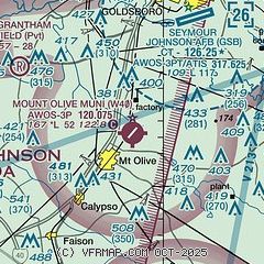
| Sectional chart |
|---|
|
| Airport distance calculator |
|---|
|
|
| Sunrise and sunset |
|---|
|
Times for 25-Oct-2025
| | Local
(UTC-4) | | Zulu
(UTC) |
|---|
| Morning civil twilight | | 07:02 | | 11:02 |
| Sunrise | | 07:28 | | 11:28 |
| Sunset | | 18:25 | | 22:25 |
| Evening civil twilight | | 18:50 | | 22:50 |
|
| Current date and time |
|---|
| Zulu (UTC) | 26-Oct-2025 03:07:24 |
|---|
| Local (UTC-4) | 25-Oct-2025 23:07:24 |
|---|
|
| METAR |
|---|
KGSB
7nm NE | 260255Z AUTO 07006KT 10SM OVC190 12/02 A3034 RMK AO2 SLP278 T01200024 50000 $
|
KDPL
14nm S | 260300Z AUTO 00000KT 10SM CLR 07/06 A3036 RMK AO2
|
KGWW
15nm N | 260300Z AUTO 06003KT 10SM CLR 09/04 A3037 RMK AO2 T00920036
|
|
| TAF |
|---|
KGSB
7nm NE | 252200Z 2522/2702 02006KT 9999 SCT180 QNH3030INS TX19/2619Z TN06/2608Z LAST NO AMDS AFT 2522 NEXT 2603
|
|
| NOTAMs |
|---|
NOTAMs are issued by the DoD/FAA and will open in a separate window not controlled by AirNav.
|
|

