FAA INFORMATION EFFECTIVE 16 APRIL 2026
Location
| FAA Identifier: | TSO |
| Lat/Long: | 40-33-42.0000N 081-04-41.1000W
40-33.700000N 081-04.685000W
40.5616667,-81.0780833
(estimated) |
| Elevation: | 1163.6 ft. / 355 m (estimated) |
| Variation: | 07W (1985) |
| From city: | 1 mile SE of CARROLLTON, OH |
| Time zone: | UTC -4 (UTC -5 during Standard Time) |
| Zip code: | 44615 |
Airport Operations
| Airport use: | Open to the public |
| Activation date: | 02/1948 |
| Control tower: | no |
| ARTCC: | CLEVELAND CENTER |
| FSS: | CLEVELAND FLIGHT SERVICE STATION |
| NOTAMs facility: | CLE (NOTAM-D service available) |
| Attendance: | UNATNDD |
| Pattern altitude: | 2013.6 ft. MSL |
| Wind indicator: | yes |
| Segmented circle: | no |
| Lights: | ACTVT REIL RWY 07 & 25; MIRL RWY 07/25 - CTAF. TWY LGTS AT TURNAROUND BUTTONS/RWY ENTRANCE. |
| Beacon: | white-green (lighted land airport)
Operates sunset to sunrise. |
Airport Communications
| CTAF/UNICOM: | 122.7 |
| CLEVELAND APPROACH: | 125.5 |
| CLEVELAND DEPARTURE: | 125.5 |
| WX ASOS at PHD (17 nm W): | 121.425 (330-339-1125) |
- APCH/DEP SVC PRVDD BY CLEVELAND APCH (CLE) 0600-0100. APCH/DEP SVC PRVDD BY CLEVELAND ARTCC (ZOB) ON FREQS 120.6/379.275 (MOUNT HOPE RCAG) 0100-0600.
Nearby radio navigation aids
| VOR radial/distance | | VOR name | | Freq | | Var |
|---|
| BSVr128/19.4 | | BRIGGS VOR/DME | | 114.05 | | 04W |
| HLGr315/29.5 | | WHEELING VOR/DME | | 114.25 | | 07W |
| ACOr174/33.2 | | AKRON VOR/DME | | 114.40 | | 04W |
| AIRr347/34.8 | | BELLAIRE VOR/DME | | 117.10 | | 07W |
| NDB name | | Hdg/Dist | | Freq | | Var | | ID |
|---|
| CADIZ | | 358/19.7 | | 239 | | 07W | | CFX | -.-. ..-. -..- |
Airport Services
| Fuel available: | 100LL JET-A
100LL:100LL & JET A AVBL H24 VIA CREDIT CARD. |
| Parking: | hangars and tiedowns |
| Airframe service: | NONE |
| Powerplant service: | NONE |
| Bottled oxygen: | NONE |
| Bulk oxygen: | NONE |
Runway Information
Runway 7/25
| Dimensions: | 4300 x 75 ft. / 1311 x 23 m |
| Surface: | asphalt, in excellent condition |
| Runway edge lights: | medium intensity |
| RUNWAY 7 | | RUNWAY 25 |
| Latitude: | 40-33.546782N | | 40-33.852733N |
| Longitude: | 081-05.103452W | | 081-04.266065W |
| Elevation: | 1161.4 ft. | | 1163.5 ft. |
| Traffic pattern: | left | | left |
| Runway heading: | 071 magnetic, 064 true | | 251 magnetic, 244 true |
| Markings: | nonprecision, in good condition | | nonprecision, in good condition |
| Visual slope indicator: | 2-light PAPI on left | | 2-light PAPI on left |
| Runway end identifier lights: | yes | | yes |
| Touchdown point: | yes, no lights | | yes, no lights |
| Obstructions: | 15 ft. trees, 201 ft. from runway, 235 ft. right of centerline
+12 FT FENCE, 0-200 FT DIST, 196 FT R. | | 42 ft. trees, 565 ft. from runway, 217 ft. left of centerline, 8:1 slope to clear
+7 BLDG, 34 FT DIST, 245 FT R. |
Airport Ownership and Management from official FAA records
| Ownership: | Publicly-owned |
| Owner: | CARROLL COUNTY ARPT AUTH
PO BOX 266
CARROLLTON, OH 44615-0266
Phone 330-323-8626 |
| Manager: | AL JESKE
PO BOX 266
CARROLLTON, OH 44615-0266
Phone 330-323-8626
RESTAURANT/FUEL ASSISTANCE 330-627-5250. |
Additional Remarks
| - | DEER ON & INVOF ARPT. |
| - | FOR CD CTC CLEVELAND APCH AT 216-352-2323, WHEN APCH CLSD CTC CLEVELAND ARTCC AT 440-774-0223/0490. |
Instrument Procedures
NOTE: All procedures below are presented as PDF files. If you need a reader for these files, you should download the free Adobe Reader.NOT FOR NAVIGATION. Please procure official charts for flight.
FAA instrument procedures published for use from 16 April 2026 at 0901Z to 14 May 2026 at 0900Z.
IAPs - Instrument Approach Procedures |
|---|
| RNAV (GPS) RWY 07 | |
download (160KB) |
| VOR-A | |
download (158KB) |
| NOTE: Special Take-Off Minimums/Departure Procedures apply | |
download (491KB) |
Other nearby airports with instrument procedures:
KPHD - Harry Clever Field Airport (17 nm W)
8G6 - Harrison County Airport (20 nm S)
3G6 - Tri-City Airport (21 nm N)
02G - Columbiana County Airport (21 nm E)
2G2 - Geary A Bates/Jefferson County Airpark (21 nm SE)
|
|

Road maps at:
MapQuest
Bing
Google
| Aerial photo |
|---|
WARNING: Photo may not be current or correct
 Photo by Brad Smith
Taken in July 2008
from a Cessna 172 at 1000 feet AGL
Photo by Brad Smith
Taken in July 2008
from a Cessna 172 at 1000 feet AGL
Do you have a better or more recent aerial photo of Carroll County/Tolson Airport that you would like to share? If so, please send us your photo.
|
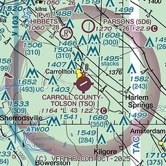
| Sectional chart |
|---|
|
| Airport distance calculator |
|---|
|
|
| Sunrise and sunset |
|---|
|
Times for 06-May-2026
| | Local
(UTC-4) | | Zulu
(UTC) |
|---|
| Morning civil twilight | | 05:48 | | 09:48 |
| Sunrise | | 06:18 | | 10:18 |
| Sunset | | 20:24 | | 00:24 |
| Evening civil twilight | | 20:54 | | 00:54 |
|
| Current date and time |
|---|
| Zulu (UTC) | 06-May-2026 21:07:57 |
|---|
| Local (UTC-4) | 06-May-2026 17:07:57 |
|---|
|
| METAR |
|---|
KPHD
16nm W | 062053Z AUTO 33009KT 10SM FEW050 BKN080 OVC120 14/02 A2986 RMK AO2 SLP114 T01440022 58001
|
KCAK
27nm NW | 062051Z 31009KT 10SM FEW050 OVC090 12/01 A2987 RMK AO2 SLP119 T01170006 53002
|
KHLG
31nm SE | 062053Z 32007KT 10SM OVC034 12/06 A2986 RMK AO2 SLP112 T01220056 53003
|
|
| TAF |
|---|
KCAK
27nm NW | 061720Z 0618/0718 31010KT P6SM BKN060 FM070000 26004KT P6SM BKN070 FM071200 30007KT P6SM BKN100
|
KHLG
31nm SE | 061907Z 0619/0718 32008KT P6SM BKN025 FM062000 31007KT P6SM SCT015 BKN040 FM070100 30004KT P6SM SCT060 FM071700 28008G16KT P6SM SCT030 BKN060
|
KBVI
33nm E | 061720Z 0618/0718 33008KT P6SM BKN020 FM062000 32007KT P6SM SCT020 BKN040 FM070300 30004KT P6SM SCT060 FM071600 29010KT P6SM SCT030 BKN060
|
|
| NOTAMs |
|---|
NOTAMs are issued by the DoD/FAA and will open in a separate window not controlled by AirNav.
|
|


