FAA INFORMATION EFFECTIVE 30 OCTOBER 2025
Location
| FAA Identifier: | BVI |
| Lat/Long: | 40-46-20.9000N 080-23-29.2000W
40-46.348333N 080-23.486667W
40.7724722,-80.3914444
(estimated) |
| Elevation: | 1252.7 ft. / 381.8 m (surveyed) |
| Variation: | 07W (1985) |
| From city: | 3 miles NW of BEAVER FALLS, PA |
| Time zone: | UTC -5 (UTC -4 during Daylight Saving Time) |
| Zip code: | 15010 |
Airport Operations
| Airport use: | Open to the public |
| Activation date: | 05/1954 |
| Control tower: | yes |
| ARTCC: | CLEVELAND CENTER |
| FSS: | ALTOONA FLIGHT SERVICE STATION |
| NOTAMs facility: | BVI (NOTAM-D service available) |
| Attendance: | MON-FRI 0700-2100, UNATNDD FED HOL 24 HOURS/DAY, ALL SAT-SUN 0900-1600 |
| Wind indicator: | lighted |
| Segmented circle: | no |
| Lights: | ATCT-CTL. WHEN ATCT CLSD MIRL RWY 10/28 & TWY LGTS OPER LOW INTST. INCR INTST & ACTVT REIL RWY 10 & 28 - CTAF. PAPI RWY 10 & 28 OPER CONT. |
| Beacon: | white-green (lighted land airport)
Operates sunset to sunrise. |
Airport Communications
| CTAF: | 120.3 |
| ATIS: | 118.35 |
| WX AWOS-3PT: | 118.35 (724-843-1024) |
| BEAVER COUNTY GROUND: | 121.8 [0730-1930 MON-FRI; CLSD SAT-SUN.] |
| BEAVER COUNTY TOWER: | 120.3 [0730-1930 MON-FRI; CLSD SAT-SUN.] |
| CLEARANCE DELIVERY: | 124.85 ;WHEN TWR CLSD |
| CLASS B: | 124.75 |
| WX AWOS-3PT at PJC (11 nm E): | 118.45 (724-452-5304) |
| WX AWOS-3PT at UCP (15 nm N): | 124.175 ((724) 652-4184) |
| WX ASOS at PIT (18 nm SE): | PHONE 215-798-0218 |
- EMERG FREQ 121.5 NOT AVAILABLE AT TOWER.
- COMMUNICATIONS PRVDD BY ALTOONA RADIO ON FREQS 122.1R/115.8T (ELLWOOD CITY RCO).
Nearby radio navigation aids
| VOR radial/distance | | VOR name | | Freq | | Var |
|---|
| EWCr257/8.8 | | ELLWOOD CITY VOR/DME | | 115.80 | | 08W |
| HLGr022/31.8 | | WHEELING VOR/DME | | 114.25 | | 07W |
| AGCr341/33.7 | | ALLEGHENY VOR/DME | | 110.00 | | 09W |
| NDB name | | Hdg/Dist | | Freq | | Var | | ID |
|---|
| CASTLE | | 185/15.1 | | 272 | | 09W | | UCP | ..- -.-. .--. |
Airport Services
| Fuel available: | 100LL JET-A JET-A+ |
| Parking: | hangars and tiedowns |
| Airframe service: | MAJOR |
| Powerplant service: | MAJOR |
| Bottled oxygen: | NONE |
| Bulk oxygen: | NONE |
Runway Information
Runway 10/28
| Dimensions: | 4501 x 100 ft. / 1372 x 30 m |
| Surface: | asphalt/grooved, in good condition |
| Weight bearing capacity: | | Single wheel: | 16.0 | | Double wheel: | 32.0 |
|
| Runway edge lights: | medium intensity |
| RUNWAY 10 | | RUNWAY 28 |
| Latitude: | 40-46.373098N | | 40-46.323318N |
| Longitude: | 080-23.972207W | | 080-22.999535W |
| Elevation: | 1204.2 ft. | | 1252.7 ft. |
| Traffic pattern: | left | | left |
| Runway heading: | 101 magnetic, 094 true | | 281 magnetic, 274 true |
| Markings: | nonprecision, in fair condition | | nonprecision, in fair condition |
| Visual slope indicator: | 4-light PAPI on left (3.00 degrees glide path) | | 4-light PAPI on left (3.00 degrees glide path) |
| Runway end identifier lights: | yes | | yes
RWY 28 REILS OTS INDEFLY. |
| Touchdown point: | yes, no lights | | yes, no lights |
| Instrument approach: | LOCALIZER | | |
| Obstructions: | 78 ft. trees, 1759 ft. from runway, 286 ft. right of centerline, 19:1 slope to clear | | 18 ft. trees, 622 ft. from runway, 117 ft. left of centerline, 23:1 slope to clear
RWY 28: 20 FT TREES, 13 FT FM RWY END, 195 FT LEFT. |
Airport Ownership and Management from official FAA records
| Ownership: | Publicly-owned |
| Owner: | BEAVER COUNTY AIRPORT AUTHORITY
COURT HOUSE
BEAVER, PA 15009
Phone 724-728-3934 |
| Manager: | TIMOTHY NESTOR
15 PIPER ST
BEAVER FALLS, PA 15010
Phone 724-847-4662 |
Additional Remarks
| - | NOISE ABATEMENT PROCS IN EFCT FOR DEPS ONLY, CTC AMGR 0800-1600 FOR DTLS AT 724-847-4662. |
| E94 | SAWRS. |
Instrument Procedures
NOTE: All procedures below are presented as PDF files. If you need a reader for these files, you should download the free Adobe Reader.NOT FOR NAVIGATION. Please procure official charts for flight.
FAA instrument procedures published for use from 30 October 2025 at 0901Z to 27 November 2025 at 0900Z.
IAPs - Instrument Approach Procedures |
|---|
| RNAV (GPS) RWY 10 | |
download (234KB) |
| RNAV (GPS) RWY 28 | |
download (247KB) |
| LOC RWY 10 | |
download (239KB) |
| VOR RWY 28 | |
download (245KB) |
| NOTE: Special Alternate Minimums apply | |
download (42KB) |
| NOTE: Special Take-Off Minimums/Departure Procedures apply | |
download (149KB) |
Other nearby airports with instrument procedures:
KPJC - Zelienople Municipal Airport (11 nm E)
02G - Columbiana County Airport (13 nm SW)
KUCP - New Castle Municipal Airport (15 nm N)
4G4 - Youngstown Elser Metro Airport (17 nm NW)
KPIT - Pittsburgh International Airport (18 nm SE)
|
|

Road maps at:
MapQuest
Bing
Google
| Aerial photo |
|---|
WARNING: Photo may not be current or correct
 Photo by Steve Kalasky
Taken in September 2012
looking northeast.
Photo by Steve Kalasky
Taken in September 2012
looking northeast.
Do you have a better or more recent aerial photo of Beaver County Airport that you would like to share? If so, please send us your photo.
|
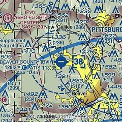
| Sectional chart |
|---|
|
CAUTION: Diagram may not be current

| Airport distance calculator |
|---|
|
|
| Sunrise and sunset |
|---|
|
Times for 25-Nov-2025
| | Local
(UTC-5) | | Zulu
(UTC) |
|---|
| Morning civil twilight | | 06:51 | | 11:51 |
| Sunrise | | 07:21 | | 12:21 |
| Sunset | | 16:56 | | 21:56 |
| Evening civil twilight | | 17:26 | | 22:26 |
|
| Current date and time |
|---|
| Zulu (UTC) | 25-Nov-2025 15:09:44 |
|---|
| Local (UTC-5) | 25-Nov-2025 10:09:44 |
|---|
|
| METAR |
|---|
| KBVI | 251455Z AUTO 17005KT 7SM -RA BKN012 OVC024 09/07 A2996 RMK AO2 T00860066
|
KPJC
11nm E | 251455Z AUTO 00000KT 10SM BKN027 03/03 A2997 RMK AO2 P0006
|
KUCP
15nm N | 251456Z AUTO VRB06KT 7SM -RA SCT020 BKN033 OVC039 07/06 A2996 RMK AO2 SLP166 P0006 60006 T00670061 58008
|
KPIT
17nm S | 251504Z 16007KT 3SM RA BR BKN009 BKN015 OVC028 09/08 A2997 RMK AO2 P0002 T00890078
|
|
| TAF |
|---|
| KBVI | 251122Z 2512/2612 17006KT P6SM -RA OVC050 FM251500 17007KT 4SM -RA BR OVC015 FM251700 18008KT 3SM -RA BR BKN007 TEMPO 2522/2602 3SM -RA BR BKN004 FM260300 20006KT 6SM -SHRA BR OVC006
|
KPIT
17nm S | 251122Z 2512/2618 15005KT P6SM -RA OVC040 FM251500 17008KT 3SM -RA BR OVC015 FM251700 17008KT 3SM -RA BR BKN007 FM260200 20006KT 6SM -SHRA BR OVC007 FM261200 22009G16KT P6SM VCSH OVC015 FM261600 25015G25KT 6SM -SHRA BKN030
|
|
| NOTAMs |
|---|
NOTAMs are issued by the DoD/FAA and will open in a separate window not controlled by AirNav.
|
|


