FAA INFORMATION EFFECTIVE 11 JUNE 2026
Location
| FAA Identifier: | SCR |
| Lat/Long: | 35-42-15.3880N 079-30-15.4720W
35-42.256467N 079-30.257867W
35.7042744,-79.5042978
(estimated) |
| Elevation: | 615.6 ft. / 187.6 m (surveyed) |
| Variation: | 09W (2015) |
| From city: | 3 miles SW of SILER CITY, NC |
| Time zone: | UTC -4 (UTC -5 during Standard Time) |
| Zip code: | 27344 |
Airport Operations
| Airport use: | Open to the public |
| Activation date: | 07/1965 |
| Control tower: | no |
| ARTCC: | ATLANTA CENTER |
| FSS: | RALEIGH FLIGHT SERVICE STATION |
| NOTAMs facility: | RDU (NOTAM-D service available) |
| Attendance: | SUN 1200-1700, ALL MON-SAT 0900-1700 |
| Wind indicator: | lighted |
| Segmented circle: | yes |
| Lights: | ACTVT REILS RWY 04 & 22; MIRL RWY 04/22 - CTAF. PAPI RWY 04 & 22 OPER CONSLY. |
| Beacon: | white-green (lighted land airport)
Operates sunset to sunrise. |
Airport Communications
| CTAF/UNICOM: | 122.7 |
| WX AWOS-3: | 125.775 (919-663-1252) |
| GREENSBORO APPROACH: | 126.6 |
| GREENSBORO DEPARTURE: | 126.6 |
| WX AWOS-3 at HBI (19 nm W): | 119.275 (336-626-7933) |
Nearby radio navigation aids
| VOR radial/distance | | VOR name | | Freq | | Var |
|---|
| LIBr144/8.3 | | LIBERTY VORTAC | | 113.00 | | 03W |
| SDZr011/29.6 | | SANDHILLS VORTAC | | 111.80 | | 03W |
| GSOr135/30.8 | | GREENSBORO VORTAC | | 116.20 | | 03W |
| RDUr263/36.5 | | RALEIGH/DURHAM VORTAC | | 117.20 | | 09W |
Airport Services
| Fuel available: | 100LL JET-A1+
100LL:24 HR CREDIT CARD SVC AVBL FOR 100LL AND JET A. |
| Parking: | tiedowns |
| Airframe service: | MAJOR |
| Powerplant service: | MAJOR |
| Bulk oxygen: | NONE |
Runway Information
Runway 4/22
| Dimensions: | 5000 x 75 ft. / 1524 x 23 m |
| Surface: | asphalt, in excellent condition |
| Weight bearing capacity: | |
| Runway edge lights: | medium intensity |
| RUNWAY 4 | | RUNWAY 22 |
| Latitude: | 35-41.904383N | | 35-42.608555N |
| Longitude: | 079-30.520210W | | 079-29.995500W |
| Elevation: | 598.5 ft. | | 615.1 ft. |
| Traffic pattern: | left | | left |
| Runway heading: | 040 magnetic, 031 true | | 220 magnetic, 211 true |
| Markings: | nonprecision, in fair condition | | nonprecision, in fair condition |
| Visual slope indicator: | 4-light PAPI on left (4.20 degrees glide path) | | 4-light PAPI on left (3.50 degrees glide path) |
| Runway end identifier lights: | yes | | yes |
| Touchdown point: | yes, no lights | | yes, no lights |
| Obstructions: | 45 ft. trees, 1183 ft. from runway, 247 ft. right of centerline, 21:1 slope to clear | | 48 ft. trees, 1283 ft. from runway, 249 ft. left of centerline, 22:1 slope to clear |
Airport Ownership and Management from official FAA records
| Ownership: | Publicly-owned |
| Owner: | TOWN OF SILER CITY
PO BOX 769
SILER CITY, NC 27344
Phone 919-742-4731 |
| Manager: | KAREN MCCRAW
80 AVIATION DR.
SILER CITY, NC 27344
Phone 919-742-3847 |
Additional Remarks
| - | DEER & BIRDS ON & INVOF ARPT. |
| - | ASPH SECTION OF RAMP PAVEMENT STRENGTH IS CSDRBLY LESS THAN RWY. |
| - | AFT HRS FUEL OR SVCS, CALL 919-619-2707. |
| - | SEASONAL FARMING OPNS AND EQPT INVOF RWY. |
| - | FOR CD CTC GREENSBORO APCH AT 336-333-5119. |
Instrument Procedures
NOTE: All procedures below are presented as PDF files. If you need a reader for these files, you should download the free Adobe Reader.NOT FOR NAVIGATION. Please procure official charts for flight.
FAA instrument procedures published for use from 11 June 2026 at 0901Z to 09 July 2026 at 0900z.
IAPs - Instrument Approach Procedures |
|---|
| RNAV (GPS) RWY 04 | |
download (229KB) |
| RNAV (GPS) RWY 22 | |
download (254KB) |
| NOTE: Special Alternate Minimums apply | |
download (151KB) |
| NOTE: Special Take-Off Minimums/Departure Procedures apply | |
download (202KB) |
Other nearby airports with instrument procedures:
KHBI - Asheboro Regional Airport (19 nm W)
KBUY - Burlington/Alamance Regional Airport (21 nm N)
KTTA - Raleigh Executive Jetport at Sanford-Lee County Airport (21 nm E)
43A - Montgomery County Airport (24 nm SW)
KSOP - Moore County Airport (29 nm S)
|
|

Road maps at:
MapQuest
Bing
Google
| Aerial photo |
|---|
WARNING: Photo may not be current or correct
 Photo taken 03-Jun-2014
looking southwest.
Photo taken 03-Jun-2014
looking southwest.
Do you have a better or more recent aerial photo of Siler City Municipal Airport that you would like to share? If so, please send us your photo.
|
| Sectional chart |
|---|
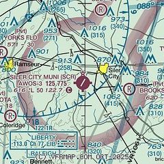
|
| Airport distance calculator |
|---|
|
|
| Sunrise and sunset |
|---|
|
Times for 18-Jun-2026
| | Local
(UTC-4) | | Zulu
(UTC) |
|---|
| Morning civil twilight | | 05:33 | | 09:33 |
| Sunrise | | 06:03 | | 10:03 |
| Sunset | | 20:35 | | 00:35 |
| Evening civil twilight | | 21:05 | | 01:05 |
|
| Current date and time |
|---|
| Zulu (UTC) | 18-Jun-2026 18:27:04 |
|---|
| Local (UTC-4) | 18-Jun-2026 14:27:04 |
|---|
|
| METAR |
|---|
| KSCR | 181815Z AUTO 21011G17KT 10SM BKN050 BKN060 33/21 A2988 RMK AO2 T03300209
|
KHBI
20nm W | 181755Z AUTO 23013G23KT 10SM SCT046 SCT055 BKN085 32/19 A2990 RMK AO2 T03200189 10322 20242
|
|
| TAF |
|---|
KGSO
32nm NW | 181720Z 1818/1918 23016G27KT P6SM SCT035 BKN130 OVC250 TEMPO 1819/1823 3SM TSRA BR BKN035CB FM190000 24010KT P6SM VCSH SCT025 BKN050 BKN100 FM190400 23008KT 3SM -SHRA BR BKN009 OVC025 FM190700 VRB05KT 2SM SHRA BR OVC005 FM191300 32010KT P6SM BKN012 BKN040 FM191600 32012KT P6SM BKN060
|
KRDU
36nm E | 181720Z 1818/1918 24017G28KT P6SM FEW040 BKN140 BKN250 FM182000 24015G27KT P6SM VCTS BKN035CB BKN150 FM190000 24011KT P6SM BKN050 BKN100 FM190600 22007KT 3SM -SHRA BR BKN009 OVC025 FM190900 VRB05KT 2SM TSRA BR BKN005CB BKN020 FM191400 32010KT P6SM BKN012 BKN040 FM191700 32012KT P6SM BKN060
|
KPOB
40nm SE | 181700Z 1817/1923 24015G30KT 9999 BKN045 QNH2982INS BECMG 1908/1909 22010G25KT 4800 VCTS SHRA BKN010CB QNH2983INS BECMG 1911/1912 22010G25KT 9000 -SHRA BKN008 QNH2983INS BECMG 1913/1914 20020G30KT 1600 VCTS +SHRA OVC010CB QNH2983INS BECMG 1915/1916 23010KT 9999 NSW BKN010 QNH2970INS BECMG 1917/1918 30010KT 9999 SCT030 QNH2975INS TX37/1820Z TN24/1909Z
|
|
| NOTAMs |
|---|
NOTAMs are issued by the DoD/FAA and will open in a separate window not controlled by AirNav.
|
|

