FAA INFORMATION EFFECTIVE 16 APRIL 2026
Location
| FAA Identifier: | 00R |
| Lat/Long: | 30-41-09.1000N 095-01-04.5000W
30-41.151667N 095-01.075000W
30.6858611,-95.0179167
(estimated) |
| Elevation: | 150.7 ft. / 45.9 m (surveyed) |
| Variation: | 06E (1985) |
| From city: | 5 miles SW of LIVINGSTON, TX |
| Time zone: | UTC -5 (UTC -6 during Standard Time) |
| Zip code: | 77351 |
Airport Operations
| Airport use: | Open to the public |
| Activation date: | 10/1969 |
| Control tower: | no |
| ARTCC: | HOUSTON CENTER |
| FSS: | MONTGOMERY COUNTY FLIGHT SERVICE STATION |
| NOTAMs facility: | CXO (NOTAM-D service available) |
| Attendance: | MON-FRI 0800-1700, ALL SAT-SUN 1200-1700 |
| Wind indicator: | lighted |
| Segmented circle: | yes |
| Lights: | SS-SR |
| Beacon: | white-green (lighted land airport)
Operates sunset to sunrise. |
Airport Communications
| CTAF/UNICOM: | 122.7 |
| WX AWOS-3 at 6R3 (20 nm S): | 119.325 (281-593-1754) |
- APCH/DEP CTL SVC PRVDD BY HOUSTON ARTCC (ZHU) ON FREQS 125.175/285.575 (LUFKIN RCAG).
Nearby radio navigation aids
| VOR radial/distance | | VOR name | | Freq | | Var |
|---|
| LFKr203/32.5 | | LUFKIN VORTAC | | 112.10 | | 05E |
| DASr322/35.5 | | DAISETTA VORTAC | | 116.90 | | 05E |
Airport Services
| Fuel available: | 100LL |
| Parking: | hangars and tiedowns |
| Airframe service: | MAJOR |
| Powerplant service: | MAJOR |
| Bottled oxygen: | NONE |
| Bulk oxygen: | NONE |
Runway Information
Runway 12/30
| Dimensions: | 3704 x 60 ft. / 1129 x 18 m |
| Surface: | asphalt, in fair condition |
| Weight bearing capacity: | |
| Runway edge lights: | medium intensity |
| RUNWAY 12 | | RUNWAY 30 |
| Latitude: | 30-41.349980N | | 30-40.952607N |
| Longitude: | 095-01.344160W | | 095-00.807090W |
| Elevation: | 150.2 ft. | | 150.4 ft. |
| Traffic pattern: | left | | left |
| Runway heading: | 125 magnetic, 131 true | | 305 magnetic, 311 true |
| Markings: | nonprecision, in fair condition | | nonprecision, in fair condition |
| Touchdown point: | yes, no lights | | yes, no lights |
| Obstructions: | 58 ft. trees, 1200 ft. from runway, 265 ft. left and right of centerline, 17:1 slope to clear | | 80 ft. trees, 1200 ft. from runway, 265 ft. left and right of centerline, 12:1 slope to clear |
Airport Ownership and Management from official FAA records
| Ownership: | Publicly-owned |
| Owner: | CITY OF LIVINGSTON
200 WEST CHURCH
LIVINGSTON, TX 77351
Phone 936-327-4311 |
| Manager: | BILLY S. WIGGINS
200 WEST CHURCH
LIVINGSTON, TX 77351
Phone 936-327-4311
CITY MGR. |
Additional Remarks
| - | FOR CD CTC HOUSTON ARTCC AT 281-230-5622. |
Instrument Procedures
NOTE: All procedures below are presented as PDF files. If you need a reader for these files, you should download the free Adobe Reader.NOT FOR NAVIGATION. Please procure official charts for flight.
FAA instrument procedures published for use from 16 April 2026 at 0901Z to 14 May 2026 at 0900Z.
IAPs - Instrument Approach Procedures |
|---|
| RNAV (GPS) RWY 30 | |
download (187KB) |
| NOTE: Special Take-Off Minimums/Departure Procedures apply | |
download (70KB) |
Other nearby airports with instrument procedures:
6R3 - Cleveland Municipal Airport (20 nm S)
KCXO - Conroe/North Houston Regional Airport (29 nm SW)
KUTS - Huntsville Municipal Airport (30 nm W)
KLFK - Angelina County Airport (36 nm NE)
T78 - Liberty Municipal Airport (40 nm SE)
|
|

Road maps at:
MapQuest
Bing
Google
| Aerial photo |
|---|
WARNING: Photo may not be current or correct
 Photo taken 08-Jul-2018
looking southeast.
Photo taken 08-Jul-2018
looking southeast.
Do you have a better or more recent aerial photo of Livingston Municipal Airport that you would like to share? If so, please send us your photo.
|
| Sectional chart |
|---|
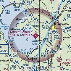
|
| Airport distance calculator |
|---|
|
|
| Sunrise and sunset |
|---|
|
Times for 04-May-2026
| | Local
(UTC-5) | | Zulu
(UTC) |
|---|
| Morning civil twilight | | 06:09 | | 11:09 |
| Sunrise | | 06:34 | | 11:34 |
| Sunset | | 19:59 | | 00:59 |
| Evening civil twilight | | 20:25 | | 01:25 |
|
| Current date and time |
|---|
| Zulu (UTC) | 04-May-2026 13:39:01 |
|---|
| Local (UTC-5) | 04-May-2026 08:39:01 |
|---|
|
| METAR |
|---|
K6R3
20nm S | 041315Z AUTO 00000KT 10SM CLR 13/12 A3002 RMK AO2 T01310121
|
KCXO
29nm SW | 041253Z 00000KT 10SM CLR 14/13 A3001 RMK AO2 SLP159 T01440128
|
KUTS
29nm W | 041253Z AUTO 18005KT 10SM CLR 17/12 A3000 RMK AO1 SLP154 T01670117
|
KLFK
36nm NE | 041253Z AUTO 14004KT 10SM CLR 14/12 A3001 RMK AO2 SLP160 T01440117
|
|
| TAF |
|---|
KCXO
29nm SW | 041120Z 0412/0512 VRB03KT P6SM SKC FM041400 18008KT P6SM SKC FM041700 18011G21KT P6SM FEW060 FM050000 16013KT P6SM FEW045 FM050500 18008KT P6SM SCT015 BKN045 FM050900 17008KT P6SM OVC015
|
KUTS
29nm W | 041120Z 0412/0512 18007KT P6SM SKC FM041500 18010G20KT P6SM FEW060 FM050000 18010KT P6SM SCT050 SCT250 FM050900 19011KT P6SM OVC015
|
KLFK
36nm NE | 041140Z 0412/0512 17006KT P6SM SCT250 FM041600 18012G18KT P6SM SCT060 BKN250 FM050000 17010KT P6SM SCT250 FM050700 17009KT P6SM BKN025 FM050900 17008KT P6SM OVC015
|
|
| NOTAMs |
|---|
NOTAMs are issued by the DoD/FAA and will open in a separate window not controlled by AirNav.
|
|

