FAA INFORMATION EFFECTIVE 14 MAY 2026
Location
| FAA Identifier: | 06A |
| Lat/Long: | 32-27-37.7000N 085-40-48.1000W
32-27.628333N 085-40.801667W
32.4604722,-85.6800278
(estimated) |
| Elevation: | 264 ft. / 80.5 m (surveyed) |
| Variation: | 03W (2010) |
| From city: | 3 miles N of TUSKEGEE, AL |
| Time zone: | UTC -5 (UTC -6 during Standard Time) |
| Zip code: | 36083 |
Airport Operations
| Airport use: | Open to the public |
| Activation date: | 11/1941 |
| Control tower: | no |
| ARTCC: | ATLANTA CENTER |
| FSS: | ANNISTON FLIGHT SERVICE STATION |
| NOTAMs facility: | ANB (NOTAM-D service available) |
| Attendance: | 0700-1700
AFT HRS 334-421-4266. |
| Wind indicator: | lighted |
| Segmented circle: | yes |
| Lights: | ACTVT MIRL RWY 13/31 - CTAF. |
| Beacon: | white-green (lighted land airport)
Operates sunset to sunrise. |
Airport Communications
| CTAF/UNICOM: | 122.8 |
| ATLANTA APPROACH: | 125.5 126.55 ;7000 FT & ABV |
| ATLANTA DEPARTURE: | 125.5 126.55 ;7000 FT & ABV |
| WX AWOS-3PT at AUO (16 nm NE): | 132.575 (334-501-0387) |
- APCH/DEP SVC PRVDD BY ATLANTA LARGE TRACON 125.5 (0515-2200) OTHER TIMES ATLANTA ARTCC 120.45/298.850 (COLUMBUS RCAG).
Nearby radio navigation aids
| VOR radial/distance | | VOR name | | Freq | | Var |
|---|
| MGMr063/35.4 | | MONTGOMERY VORTAC | | 112.10 | | 03E |
| LSFr287/35.6 | | LAWSON VOR/DME | | 111.40 | | 05W |
Airport Services
| Fuel available: | 100LL JET-A+ |
| Parking: | hangars and tiedowns |
| Airframe service: | NONE |
| Powerplant service: | NONE |
| Bottled oxygen: | NONE |
| Bulk oxygen: | NONE |
Runway Information
Runway 13/31
| Dimensions: | 5005 x 100 ft. / 1526 x 30 m |
| Surface: | asphalt, in fair condition |
| Weight bearing capacity: | |
| Runway edge lights: | medium intensity |
| RUNWAY 13 | | RUNWAY 31 |
| Latitude: | 32-27.886912N | | 32-27.369283N |
| Longitude: | 085-41.181352W | | 085-40.423030W |
| Elevation: | 263.9 ft. | | 263.8 ft. |
| Traffic pattern: | left | | left |
| Runway heading: | 132 magnetic, 129 true | | 312 magnetic, 309 true |
| Markings: | nonprecision, in fair condition | | nonprecision, in fair condition |
| Visual slope indicator: | 2-light PAPI on left (3.00 degrees glide path)
OTS | | 2-light PAPI on left (3.00 degrees glide path)
OTS |
| Touchdown point: | yes, no lights | | yes, no lights |
| Obstructions: | 18 ft. trees, 274 ft. from runway, 136 ft. left of centerline, 4:1 slope to clear | | 109 ft. trees, 1265 ft. from runway, 47 ft. left of centerline, 9:1 slope to clear |
Airport Ownership and Management from official FAA records
| Ownership: | Publicly-owned |
| Owner: | CITY OF TUSKEGEE
101 FONVILLE ST
TUSKEGEE, AL 36083
Phone 334-727-2180 |
| Manager: | NIKKI JORDAN
1729 GENERAL B.O. DAVIS JR DRIVE
TUSKEGEE, AL 36083
Phone 334-724-0208 |
Additional Remarks
| - | PARL TWY LGTD FULL LEN. |
| - | WILDLIFE ON & INVOF ARPT. |
| - | FOR CD CTC ATLANTA APCH AT 678-364-6132, WHEN APCH CLSD CTC ATLANTA ARTCC AT 770-210-7692. |
Instrument Procedures
NOTE: All procedures below are presented as PDF files. If you need a reader for these files, you should download the free Adobe Reader.NOT FOR NAVIGATION. Please procure official charts for flight.
FAA instrument procedures published for use from 14 May 2026 at 0901Z to 11 June 2026 at 0900Z.
IAPs - Instrument Approach Procedures |
|---|
| RNAV (GPS) RWY 13 | |
download (259KB) |
| RNAV (GPS) RWY 31 | |
download (240KB) |
| NOTE: Special Take-Off Minimums/Departure Procedures apply | |
download (490KB) |
Other nearby airports with instrument procedures:
KAUO - Auburn University Regional Airport (16 nm NE)
07A - Franklin Field Airport (19 nm S)
KALX - Thomas C Russell Field Airport (31 nm NW)
7A3 - Lanett Regional Airport (31 nm NE)
08A - Wetumpka Municipal Airport (33 nm W)
|
|

Road maps at:
MapQuest
Bing
Google
| Aerial photo |
|---|
WARNING: Photo may not be current or correct
 Photo courtesy of Golden Eagle Aviation
Photo taken 23-Dec-2010
looking northwest.
Photo courtesy of Golden Eagle Aviation
Photo taken 23-Dec-2010
looking northwest.
Do you have a better or more recent aerial photo of Moton Field Municipal Airport that you would like to share? If so, please send us your photo.
|
| Sectional chart |
|---|
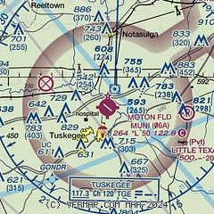
|
CAUTION: Diagram may not be current

| Airport distance calculator |
|---|
|
|
| Sunrise and sunset |
|---|
|
Times for 21-May-2026
| | Local
(UTC-5) | | Zulu
(UTC) |
|---|
| Morning civil twilight | | 05:14 | | 10:14 |
| Sunrise | | 05:42 | | 10:42 |
| Sunset | | 19:37 | | 00:37 |
| Evening civil twilight | | 20:04 | | 01:04 |
|
| Current date and time |
|---|
| Zulu (UTC) | 21-May-2026 11:51:53 |
|---|
| Local (UTC-5) | 21-May-2026 06:51:53 |
|---|
|
| METAR |
|---|
KAUO
16nm NE | 211056Z AUTO 00000KT 9SM CLR 21/ A3006 RMK AO2 SLP166 T0206 $
|
KALX
31nm NW | 211135Z AUTO 06001KT 10SM FEW090 21/20 A3005 RMK AO2
|
|
| TAF |
|---|
KAUO
16nm NE | 210527Z 2106/2206 12006KT P6SM SCT040 BKN100 FM210800 VRB03KT P6SM VCSH OVC015 TEMPO 2111/2115 VRB03KT 4SM BR OVC007 FM211800 20006KT P6SM VCSH OVC050 PROB30 2120/2124 VRB10G20KT 2SM TSRA OVC035CB
|
|
| NOTAMs |
|---|
NOTAMs are issued by the DoD/FAA and will open in a separate window not controlled by AirNav.
|
|


