FAA INFORMATION EFFECTIVE 16 APRIL 2026
Location
| FAA Identifier: | 0M5 |
| Lat/Long: | 36-06-59.8000N 087-44-17.4000W
36-06.996667N 087-44.290000W
36.1166111,-87.7381667
(estimated) |
| Elevation: | 755.8 ft. / 230.4 m (surveyed) |
| Variation: | 02W (2010) |
| From city: | 3 miles NE of WAVERLY, TN |
| Time zone: | UTC -5 (UTC -6 during Standard Time) |
| Zip code: | 37185 |
Airport Operations
| Airport use: | Open to the public |
| Activation date: | 12/1964 |
| Control tower: | no |
| ARTCC: | MEMPHIS CENTER |
| FSS: | JACKSON FLIGHT SERVICE STATION |
| NOTAMs facility: | MKL (NOTAM-D service available) |
| Attendance: | M-F 0800-1700 |
| Wind indicator: | lighted |
| Segmented circle: | yes |
| Lights: | ACTVT REIL RWY 03/21 - CTAF. |
| Beacon: | white-green (lighted land airport)
Operates sunset to sunrise. |
Airport Communications
| CTAF/UNICOM: | 122.8 |
| WX AWOS-3 at M02 (15 nm E): | 123.875 (615-446-5481) |
- APCH/DEP SVC PRVDD BY MEMPHIS ARTCC ON FREQS 125.85/379.25 (CENTERVILLE RCAG).
Nearby radio navigation aids
| VOR radial/distance | | VOR name | | Freq | | Var |
|---|
| CKVr208/34.2 | | CLARKSVILLE VOR/DME | | 110.60 | | 01W |
Airport Services
| Fuel available: | 100LL JET-A+
100LL:FUEL AVBL 24/7 WITH CC. |
| Parking: | hangars and tiedowns |
Runway Information
Runway 3/21
| Dimensions: | 4000 x 75 ft. / 1219 x 23 m |
| Surface: | asphalt, in good condition |
| Weight bearing capacity: | |
| Runway edge lights: | medium intensity |
| RUNWAY 3 | | RUNWAY 21 |
| Latitude: | 36-06.711465N | | 36-07.280383N |
| Longitude: | 087-44.494725W | | 087-44.084038W |
| Elevation: | 754.7 ft. | | 739.5 ft. |
| Traffic pattern: | left | | left |
| Runway heading: | 032 magnetic, 030 true | | 212 magnetic, 210 true |
| Markings: | nonprecision, in good condition | | nonprecision, in good condition |
| Visual slope indicator: | 2-light PAPI on left (3.00 degrees glide path) | | 2-light PAPI on left (3.00 degrees glide path) |
| Runway end identifier lights: | yes | | yes |
| Touchdown point: | yes, no lights | | yes, no lights |
| Obstructions: | 114 ft. tree, 3672 ft. from runway, 237 ft. left of centerline, 30:1 slope to clear | | 34 ft. tree, 557 ft. from runway, 149 ft. right of centerline, 10:1 slope to clear |
Airport Ownership and Management from official FAA records
| Ownership: | Publicly-owned |
| Owner: | HUMPHREYS COUNTY
COUNTY COURTHOUSE, RM 1, ANNEX BLDG
WAVERLY, TN 37185
Phone 931-296-7795 |
| Manager: | JEFF FINCHER
1005 AIRPORT ROAD
WAVERLY, TN 37185
Phone 931-296-2719
205-496-8130 |
Additional Remarks
| - | FOR CD CTC MEMPHIS ARTCC AT 901-368-8453/8449. |
| - | LCL SKYDIVING OPS FRI-SUN. |
| - | WILDLIFE ON & INVOF ARPT. |
Instrument Procedures
NOTE: All procedures below are presented as PDF files. If you need a reader for these files, you should download the free Adobe Reader.NOT FOR NAVIGATION. Please procure official charts for flight.
FAA instrument procedures published for use from 16 April 2026 at 0901Z to 14 May 2026 at 0900Z.
IAPs - Instrument Approach Procedures |
|---|
| RNAV (GPS) RWY 03 | |
download (206KB) |
| RNAV (GPS) RWY 21 | |
download (201KB) |
| NOTE: Special Take-Off Minimums/Departure Procedures apply | |
download (400KB) |
Other nearby airports with instrument procedures:
M02 - Dickson Municipal Airport (15 nm E)
0M4 - Benton County Airport (20 nm W)
KGHM - Centerville Municipal Airport (22 nm SE)
KEOD - Sabre Army Airfield (Fort Campbell) (30 nm NE)
KPHT - Henry County Airport (34 nm NW)
|
|

Road maps at:
MapQuest
Bing
Google
| Aerial photo |
|---|
WARNING: Photo may not be current or correct
 Photo by Eve Cascella
Photo taken 20-Jun-2008
looking north
Photo by Eve Cascella
Photo taken 20-Jun-2008
looking north
Do you have a better or more recent aerial photo of Humphreys County Airport that you would like to share? If so, please send us your photo.
|
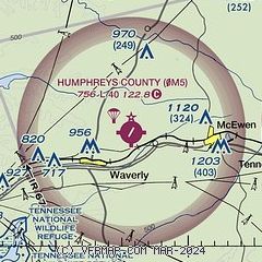
| Sectional chart |
|---|
|
| Airport distance calculator |
|---|
|
|
| Sunrise and sunset |
|---|
|
Times for 21-Apr-2026
| | Local
(UTC-5) | | Zulu
(UTC) |
|---|
| Morning civil twilight | | 05:44 | | 10:44 |
| Sunrise | | 06:11 | | 11:11 |
| Sunset | | 19:28 | | 00:28 |
| Evening civil twilight | | 19:55 | | 00:55 |
|
| Current date and time |
|---|
| Zulu (UTC) | 21-Apr-2026 12:51:31 |
|---|
| Local (UTC-5) | 21-Apr-2026 07:51:31 |
|---|
|
| METAR |
|---|
KM02
15nm E | 211235Z AUTO 22005KT 10SM CLR 14/07 A3027 RMK A01
|
KEOD
30nm NE | 211155Z AUTO 22004KT 9SM CLR 11/08 A3027 RMK AO2 SLP252 T01090079 10109 20085 53011
|
|
| NOTAMs |
|---|
NOTAMs are issued by the DoD/FAA and will open in a separate window not controlled by AirNav.
|
|

