FAA INFORMATION EFFECTIVE 14 MAY 2026
Location
| FAA Identifier: | 12K |
| Lat/Long: | 40-02-46.3195N 098-03-40.5196W
40-02.771992N 098-03.675327W
40.0461999,-98.0612554
(estimated) |
| Elevation: | 1691.5 ft. / 515.6 m (surveyed) |
| Variation: | 05E (2010) |
| From city: | 2 miles N of SUPERIOR, NE |
| Time zone: | UTC -5 (UTC -6 during Standard Time) |
| Zip code: | 68978 |
Airport Operations
| Airport use: | Open to the public |
| Activation date: | 01/1947 |
| Control tower: | no |
| ARTCC: | MINNEAPOLIS CENTER |
| FSS: | COLUMBUS FLIGHT SERVICE STATION |
| NOTAMs facility: | OLU (NOTAM-D service available) |
| Attendance: | MON-FRI 0800-1700
FOR ATTENDANT AFT HRS CALL 402-879-5852 OR 402-879-1383. |
| Wind indicator: | lighted |
| Segmented circle: | yes |
| Lights: | ACTVT MIRL, PAPI & REIL RWY 14/32 - CTAF. |
| Beacon: | white-green (lighted land airport)
Operates sunset to sunrise. |
Airport Communications
- APCH/DEP SVC PRVDD BY MINNEAPOLIS ARTCC ON FREQS 119.4/278.8 (HASTINGS RCAG).
Nearby radio navigation aids
| NDB name | | Hdg/Dist | | Freq | | Var | | ID |
|---|
| BEKLOF | | 212/39.7 | | 392 | | 03E | | FMZ | ..-. -- --.. |
Airport Services
| Fuel available: | 100LL |
| Parking: | hangars and tiedowns |
| Bottled oxygen: | NONE |
| Bulk oxygen: | NONE |
Runway Information
Runway 14/32
| Dimensions: | 4301 x 75 ft. / 1311 x 23 m |
| Surface: | concrete, in excellent condition |
| Runway edge lights: | medium intensity |
| RUNWAY 14 | | RUNWAY 32 |
| Latitude: | 40-03.030852N | | 40-02.450832N |
| Longitude: | 098-03.833488W | | 098-03.304718W |
| Elevation: | 1691.5 ft. | | 1639.4 ft. |
| Traffic pattern: | left | | left |
| Runway heading: | 140 magnetic, 145 true | | 320 magnetic, 325 true |
| Markings: | nonprecision, in good condition | | nonprecision, in good condition |
| Visual slope indicator: | 2-light PAPI on left (3.00 degrees glide path) | | 2-light PAPI on left (3.00 degrees glide path) |
| Runway end identifier lights: | yes | | yes |
| Touchdown point: | yes, no lights | | yes, no lights |
| Obstructions: | none
CLNC SLP 35:1 DUE TO ROAD, 21 FT ABV RWY END, 943 FT OUT, 327 R FM RWY END. | | 38 ft. tree, 1018 ft. from runway, 19 ft. right of centerline, 21:1 slope to clear |
Runway 18/36
| Dimensions: | 2999 x 200 ft. / 914 x 61 m |
| Surface: | turf, in fair condition |
| RUNWAY 18 | | RUNWAY 36 |
| Latitude: | 40-03.059500N | | 40-02.573833N |
| Longitude: | 098-03.769333W | | 098-03.886000W |
| Elevation: | 1682.0 ft. | | 1691.0 ft. |
| Traffic pattern: | left | | left |
| Runway heading: | 185 magnetic, 190 true | | 005 magnetic, 010 true |
| Touchdown point: | yes, no lights | | yes, no lights |
Airport Ownership and Management from official FAA records
| Ownership: | Publicly-owned |
| Owner: | SUPERIOR AIRPORT AUTHORITY
422 HIGHWAY 14
SUPERIOR, NE 68978-1021
Phone 402-879-3006
LUKE MEYERS, CHAIRMAN. |
| Manager: | LUKE MEYERS
422 HIGHWAY 14
SUPERIOR, NE 68978-9503
Phone 402-879-3006 |
Additional Remarks
| - | FOR CD CTC MINNEAPOLIS ARTCC AT 651-463-5588. |
Instrument Procedures
NOTE: All procedures below are presented as PDF files. If you need a reader for these files, you should download the free Adobe Reader.NOT FOR NAVIGATION. Please procure official charts for flight.
FAA instrument procedures published for use from 14 May 2026 at 0901Z to 11 June 2026 at 0900Z.
IAPs - Instrument Approach Procedures |
|---|
| RNAV (GPS) RWY 14 | |
download (225KB) |
| RNAV (GPS) RWY 32 | |
download (250KB) |
| NOTE: Special Take-Off Minimums/Departure Procedures apply | |
download (147KB) |
Other nearby airports with instrument procedures:
7V7 - Red Cloud Municipal Airport (22 nm W)
KHJH - Hebron Municipal Airport (23 nm E)
KRPB - Belleville Municipal Airport (23 nm SE)
K61 - Moritz Memorial Airport (35 nm S)
KCNK - Blosser Municipal Airport (35 nm SE)
|
|

Road maps at:
MapQuest
Bing
Google
| Aerial photo |
|---|

|
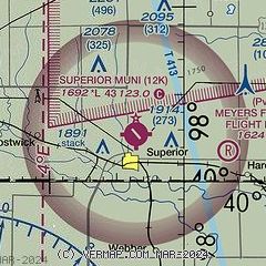
| Sectional chart |
|---|
|
| Airport distance calculator |
|---|
|
|
| Sunrise and sunset |
|---|
|
Times for 01-Jun-2026
| | Local
(UTC-5) | | Zulu
(UTC) |
|---|
| Morning civil twilight | | 05:34 | | 10:34 |
| Sunrise | | 06:06 | | 11:06 |
| Sunset | | 20:54 | | 01:54 |
| Evening civil twilight | | 21:26 | | 02:26 |
|
| Current date and time |
|---|
| Zulu (UTC) | 02-Jun-2026 03:09:43 |
|---|
| Local (UTC-5) | 01-Jun-2026 22:09:43 |
|---|
|
| METAR |
|---|
KHJH
23nm E | 020255Z AUTO 00000KT 10SM CLR 25/17 A3007 RMK AO2 T02450173
|
KCNK
35nm SE | 020255Z AUTO 11004KT 10SM CLR 25/19 A3006 RMK AO2 LTG DSNT S AND SW SLP164 60000 T02500194 53012
|
KHSI
37nm NW | 020253Z AUTO 10007KT 10SM BKN110 26/15 A3009 RMK AO2 SLP174 T02560150 51018
|
KK82
38nm SW | 020255Z AUTO 12010KT 10SM SCT050 SCT060 BKN120 24/20 A3012 RMK AO2 LTG DSNT SW T02410198
|
|
| NOTAMs |
|---|
NOTAMs are issued by the DoD/FAA and will open in a separate window not controlled by AirNav.
|
|

