FAA INFORMATION EFFECTIVE 12 JUNE 2025
Location
| FAA Identifier: | 12G |
| Lat/Long: | 40-52-22.3000N 082-41-50.6000W
40-52.371667N 082-41.843333W
40.8728611,-82.6973889
(estimated) |
| Elevation: | 1120.4 ft. / 341.5 m (surveyed) |
| Variation: | 06W (1985) |
| From city: | 2 miles W of SHELBY, OH |
| Time zone: | UTC -4 (UTC -5 during Standard Time) |
| Zip code: | 44875 |
Airport Operations
| Airport use: | Open to the public |
| Activation date: | 12/1948 |
| Control tower: | no |
| ARTCC: | CLEVELAND CENTER |
| FSS: | CLEVELAND FLIGHT SERVICE STATION |
| NOTAMs facility: | CLE (NOTAM-D service available) |
| Attendance: | 0600-1700 |
| Wind indicator: | lighted |
| Segmented circle: | no |
| Lights: | SS-SR |
| Beacon: | white-green (lighted land airport)
Operates sunset to sunrise. |
Airport Communications
| CTAF/UNICOM: | 122.8 |
| CLEVELAND APPROACH: | 128.35 |
| CLEVELAND DEPARTURE: | 128.35 |
| WX ASOS at MFD (9 nm E): | 125.3 (419-520-7277) |
| WX AWOS-3 at 17G (14 nm SW): | 126.625 (419-562-0279) |
- APCH/DEP SVC PRVDD BY CLEVELAND APCH (CLE) 0600-0100. APCH/DEP SVC PRVDD BY CLEVELAND ARTCC (ZOB) ON FREQS 134.9/269.475 (MANSFIELD RCAG) 0100-0600.
Nearby radio navigation aids
| VOR radial/distance | | VOR name | | Freq | | Var |
|---|
| MFDr276/4.8 | | MANSFIELD VORTAC | | 108.80 | | 03W |
| BUDr052/(22.7) | | BUCKEYE VOR | | 109.80 | | 05W |
| DJBr225/37.9 | | DRYER VOR/DME | | 113.60 | | 05W |
| NDB name | | Hdg/Dist | | Freq | | Var | | ID |
|---|
| MANNS | | 305/13.1 | | 372 | | 06W | | MF | -- ..-. |
| TIFFIN | | 125/27.0 | | 269 | | 05W | | TII | - .. .. |
Airport Services
| Parking: | hangars and tiedowns |
Runway Information
Runway 18/36
| Dimensions: | 3174 x 50 ft. / 967 x 15 m |
| Surface: | asphalt, in fair condition |
| Weight bearing capacity: | |
| Runway edge lights: | non-standard
NSTD LIRL DUE TO RWY 18 THR LGTS 220 FT FM RWY END; RWY LGTS 62 FT FM EAST EDGE & 47 FT FM WEST EDGE. |
| RUNWAY 18 | | RUNWAY 36 |
| Latitude: | 40-52.573192N | | 40-52.050600N |
| Longitude: | 082-41.813367W | | 082-41.803177W |
| Elevation: | 1117.5 ft. | | 1119.4 ft. |
| Traffic pattern: | left | | left |
| Runway heading: | 185 magnetic, 179 true | | 005 magnetic, 359 true |
| Markings: | basic, in good condition | | basic, in good condition |
| Runway end identifier lights: | no | | no |
| Touchdown point: | yes, no lights | | yes, no lights |
| Obstructions: | 15 ft. road, 201 ft. from runway
ROAD 165'FM RWY END 125'R. | | 94 ft. pline, 1810 ft. from runway, 289 ft. left of centerline, 17:1 slope to clear
SEASONAL CROPS 75 FT L/R, UP TO 10 FT. |
Runway 3/21
| Dimensions: | 1890 x 125 ft. / 576 x 38 m |
| Surface: | turf, in good condition |
| RUNWAY 3 | | RUNWAY 21 |
| Latitude: | 40-52.329738N | | 40-52.611560N |
| Longitude: | 082-41.988327W | | 082-41.814255W |
| Elevation: | 1120.4 ft. | | 1118.3 ft. |
| Traffic pattern: | left | | left |
| Runway heading: | 031 magnetic, 025 true | | 211 magnetic, 205 true |
| Markings: | none | | none |
| Runway end identifier lights: | no | | no |
| Touchdown point: | yes, no lights | | yes, no lights |
| Obstructions: | 75 ft. tree, 345 ft. from runway, 70 ft. left of centerline, 4:1 slope to clear | | 42 ft. bldg, 427 ft. from runway, 68 ft. left of centerline, 10:1 slope to clear |
Airport Ownership and Management from official FAA records
| Ownership: | Privately-owned |
| Owner: | SHELBY AIRPORT LLC
PO BOX 29
SHELBY, OH 44875-0029
Phone 419-347-1185 |
| Manager: | DOUG SCHMIDT
5085 STATE ROUTE 39 W
SHELBY, OH 44875-9061
Phone 419-347-1185
HOME 419-347-8543. |
Additional Remarks
| - | FOR CD CTC CLEVELAND APCH AT 216-352-2323, WHEN APCH CLSD CTC CLEVELAND ARTCC AT 440-774-0223. |
| - | RWY 18/36: 35 FT PLINE, 975 FT NORTH OF RWY END 18, NOT MKD; 95 FT PLINE, 1810 FT SOUTH OF RWY END 36, NOT MKD. |
Instrument Procedures
NOTE: All procedures below are presented as PDF files. If you need a reader for these files, you should download the free Adobe Reader.NOT FOR NAVIGATION. Please procure official charts for flight.
FAA instrument procedures published for use from 12 June 2025 at 0901Z to 10 July 2025 at 0900z.
IAPs - Instrument Approach Procedures |
|---|
| VOR-A | |
download (161KB) |
| NOTE: Special Take-Off Minimums/Departure Procedures apply | |
download (386KB) |
Other nearby airports with instrument procedures:
KGQQ - Galion Municipal Airport (7 nm S)
KMFD - Mansfield Lahm Regional Airport (9 nm E)
8G1 - Willard Airport (10 nm N)
17G - Port Bucyrus/Crawford County Airport (14 nm SW)
3G4 - Ashland County Airport (20 nm E)
|
|

Road maps at:
MapQuest
Bing
Google
| Aerial photo |
|---|
WARNING: Photo may not be current or correct
 Photo courtesy of Raptor Aviation, LLC
Do you have a better or more recent aerial photo of Shelby Community Airport that you would like to share? If so, please send us your photo.
|
| Sectional chart |
|---|
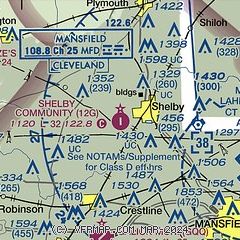
|
| Airport distance calculator |
|---|
|
|
| Sunrise and sunset |
|---|
|
Times for 30-Jun-2025
| | Local
(UTC-4) | | Zulu
(UTC) |
|---|
| Morning civil twilight | | 05:30 | | 09:30 |
| Sunrise | | 06:03 | | 10:03 |
| Sunset | | 21:06 | | 01:06 |
| Evening civil twilight | | 21:39 | | 01:39 |
|
| Current date and time |
|---|
| Zulu (UTC) | 30-Jun-2025 12:12:26 |
|---|
| Local (UTC-4) | 30-Jun-2025 08:12:26 |
|---|
|
| METAR |
|---|
KMFD
9nm E | 301152Z 15006KT 10SM FEW080 BKN110 22/21 A2998 RMK AO2 LTG DSNT SE RAB1054E07 SLP142 P0001 60005 70005 T02170206 10239 20217 50000
|
|
| TAF |
|---|
KMFD
9nm E | 300536Z 3006/0106 VRB04KT P6SM FEW100 TEMPO 3009/3012 4SM -SHRA OVC035 FM301200 VRB04KT 6SM -SHRA VCTS BKN070CB TEMPO 3012/3014 4SM -TSRA OVC025CB FM301400 19006KT 6SM -SHRA VCTS SCT070CB TEMPO 3016/3020 2SM TSRA BKN035CB FM302000 22008KT 4SM -TSRA BKN035CB FM010000 23006KT 4SM -SHRA VCTS BKN050CB PROB30 0100/0102 4SM -TSRA OVC025CB
|
|
| NOTAMs |
|---|
NOTAMs are issued by the DoD/FAA and will open in a separate window not controlled by AirNav.
|
|


