FAA INFORMATION EFFECTIVE 14 MAY 2026
Location
| FAA Identifier: | MFD |
| Lat/Long: | 40-49-17.1000N 082-30-59.9000W
40-49.285000N 082-30.998333W
40.8214167,-82.5166389
(estimated) |
| Elevation: | 1297 ft. / 395.3 m (surveyed) |
| Variation: | 06W (1985) |
| From city: | 3 miles N of MANSFIELD, OH |
| Time zone: | UTC -4 (UTC -5 during Standard Time) |
| Zip code: | 44903 |
Airport Operations
| Airport use: | Open to the public |
| Activation date: | 12/1937 |
| Control tower: | yes |
| ARTCC: | CLEVELAND CENTER |
| FSS: | CLEVELAND FLIGHT SERVICE STATION |
| NOTAMs facility: | MFD (NOTAM-D service available) |
| Attendance: | MON-FRI 0700-1900, ALL SAT-SUN 0800-1800
FBO AFT HRS CTC: 419-524-4261 / 419-989-2911. |
| Wind indicator: | lighted |
| Segmented circle: | yes |
| Lights: | WHEN ATCT CLSD ACTVT MALSR RWY 32; REIL RWY 05 & 23; PAPI RWY 14, 05, & 23; HIRL RWY 05/23 & 14/32 - CTAF. |
| Beacon: | white-green (lighted land airport)
Operates sunset to sunrise. |
| Landing fee: | no, LDG FEES ON ALL COML OPRS INVOICED MONTHLY; FOR OTR ARNGMTS CTC AMGR. |
| Fire and rescue: | ARFF index A |
| Airline operations: | CLSD TO SKEDD ACR OPS GTR THAN 9 PAX SEATS - CALL AMGR. |
Airport Communications
| CTAF: | 119.8 |
| UNICOM: | 122.95 |
| ATIS: | 125.3 |
| WX ASOS: | 125.3 (419-520-7277) |
| MANSFIELD GROUND: | 121.8 291.775 [0600-2300] |
| MANSFIELD TOWER: | 119.8 291.775 [0600-2300] |
| CLEVELAND APPROACH: | 128.35 |
| CLEVELAND DEPARTURE: | 128.35 |
| EMERG: | 121.5 |
- APCH/DEP SVC PRVDD BY CLEVELAND APCH (CLE) 0600-0100. APCH/DEP SVC PRVDD BY CLEVELAND ARTCC (ZOB) ON FREQS 134.9/269.475 (MANSFIELD RCAG) 0100-0600.
Nearby radio navigation aids
| VOR radial/distance | | VOR name | | Freq | | Var |
|---|
| BUDr069/(27.8) | | BUCKEYE VOR | | 109.80 | | 05W |
| DJBr211/36.0 | | DRYER VOR/DME | | 113.60 | | 05W |
| NDB name | | Hdg/Dist | | Freq | | Var | | ID |
|---|
| MANNS | | 322/4.6 | | 372 | | 06W | | MF | -- ..-. |
| TIFFIN | | 122/35.6 | | 269 | | 05W | | TII | - .. .. |
Airport Services
| Fuel available: | 100LL JET-A1+ |
| Parking: | hangars and tiedowns |
| Airframe service: | MAJOR |
| Powerplant service: | MAJOR |
| Bottled oxygen: | HIGH |
| Bulk oxygen: | NONE |
Runway Information
Runway 14/32
| Dimensions: | 9001 x 150 ft. / 2744 x 46 m |
| Surface: | asphalt/grooved, in fair condition |
| Weight bearing capacity: | | Single wheel: | 102.0 | | Double wheel: | 170.0 | | Double tandem: | 286.0 |
|
| Runway edge lights: | high intensity |
| RUNWAY 14 | | RUNWAY 32 |
| Latitude: | 40-49.985397N | | 40-48.902358N |
| Longitude: | 082-31.699638W | | 082-30.367670W |
| Elevation: | 1245.5 ft. | | 1289.7 ft. |
| Traffic pattern: | left | | left |
| Runway heading: | 143 magnetic, 137 true | | 323 magnetic, 317 true |
| Declared distances: | TORA:9001 TODA:9001 ASDA:9001 LDA:9001 | | TORA:9001 TODA:9001 ASDA:9001 LDA:9001 |
| Markings: | precision, in good condition | | precision, in good condition |
| Visual slope indicator: | 4-light PAPI on left (3.00 degrees glide path) | | |
| RVR equipment: | rollout | | touchdown |
| Approach lights: | | | MALSR: 1,400 foot medium intensity approach lighting system with runway alignment indicator lights |
| Runway end identifier lights: | no | | |
| Touchdown point: | yes, no lights | | yes, no lights |
| Instrument approach: | | | ILS |
| Obstructions: | 27 ft. road, 1143 ft. from runway, 629 ft. right of centerline, 34:1 slope to clear | | 58 ft. trees, 2650 ft. from runway, 250 ft. right of centerline, 42:1 slope to clear |
Runway 5/23
| Dimensions: | 6819 x 150 ft. / 2078 x 46 m |
| Surface: | asphalt/grooved, in good condition |
| Weight bearing capacity: | | Single wheel: | 91.0 | | Double wheel: | 118.0 | | Double tandem: | 175.0 |
|
| Runway edge lights: | high intensity |
| RUNWAY 5 | | RUNWAY 23 |
| Latitude: | 40-48.691220N | | 40-49.457963N |
| Longitude: | 082-31.490467W | | 082-30.410485W |
| Elevation: | 1287.0 ft. | | 1276.1 ft. |
| Traffic pattern: | left | | left |
| Runway heading: | 053 magnetic, 047 true | | 233 magnetic, 227 true |
| Declared distances: | TORA:6819 TODA:6819 ASDA:6819 LDA:6819 | | TORA:6819 TODA:6819 ASDA:6819 LDA:6819 |
| Markings: | nonprecision, in fair condition | | nonprecision, in fair condition |
| Visual slope indicator: | 4-light PAPI on left (3.00 degrees glide path) | | 4-light PAPI on left (3.00 degrees glide path) |
| Runway end identifier lights: | yes | | yes |
| Touchdown point: | yes, no lights | | yes, no lights |
| Obstructions: | none | | 48 ft. trees, 1550 ft. from runway, 600 ft. right of centerline, 28:1 slope to clear |
Airport Ownership and Management from official FAA records
| Ownership: | Publicly-owned |
| Owner: | CITY OF MANSFIELD
2000 HARRINGTON MEMORIAL RD
MANSFIELD, OH 44903-8051
Phone 419-522-2191 |
| Manager: | MARK T DAUGHERTY
2000 HARRINGTON MEMORIAL RD
MANSFIELD, OH 44903-8051
Phone 419-522-2191 |
Additional Remarks
| A39-05/23 | PCR VALUE: 374/F/D/X/T |
| A39-14/32 | PCR VALUE: 406/F/B/X/T |
| - | 11 FT FENCE, 95 FT FM TWY A CNTRLN BTN AER 05 & TWY F, DOES NOT HAVE RQRD CLNC FM TWY CNTRLN. |
| - | ACFT WITH WINGSPAN GTR THAN 132 FT ARE RESTRICTED TO 15 MPH ON TWY A. |
| - | FOR CD CTC CLEVELAND APCH AT 216-352-2323, WHEN APCH CLSD CTC CLEVELAND ARTCC AT 440-774-0223/0490. |
| - | LGTD & BARRICADED MIL RAMP CLSD TO ALL ACFT. |
| - | DEER, BIRDS, & WATERFOWL ON & INVOF ARPT. |
| - | ACFT ON EITHER END OF RWY 05/23 & 14/32 NOT VSB ON THE OTR END DUE TO RWY GRADE. |
| - | ACFT LARGER THAN A 'G1' OR WITH A WING SPAN GREATER THAN 80 FT (TIP TO TIP) ARE RESTRICTED ON TWYS G/H/J/L/M/N & SHOULD USE THE MAIN RAMP AREA. |
Instrument Procedures
NOTE: All procedures below are presented as PDF files. If you need a reader for these files, you should download the free Adobe Reader.NOT FOR NAVIGATION. Please procure official charts for flight.
FAA instrument procedures published for use from 14 May 2026 at 0901Z to 11 June 2026 at 0900z.
IAPs - Instrument Approach Procedures |
|---|
| ILS OR LOC RWY 32 | |
download (193KB) |
| RNAV (GPS) RWY 05 | |
download (213KB) |
| RNAV (GPS) RWY 14 | |
download (202KB) |
| RNAV (GPS) RWY 23 | |
download (214KB) |
| RNAV (GPS) RWY 32 | |
download (237KB) |
| NDB RWY 32 | |
download (181KB) |
| NOTE: Special Alternate Minimums apply | |
download (150KB) |
| NOTE: Special Take-Off Minimums/Departure Procedures apply | |
download (164KB) |
Other nearby airports with instrument procedures:
12G - Shelby Community Airport (9 nm W)
KGQQ - Galion Municipal Airport (10 nm SW)
3G4 - Ashland County Airport (13 nm NE)
8G1 - Willard Airport (16 nm NW)
17G - Port Bucyrus/Crawford County Airport (21 nm W)
|
|

Road maps at:
MapQuest
Bing
Google
| Aerial photo |
|---|
WARNING: Photo may not be current or correct

Do you have a better or more recent aerial photo of Mansfield Lahm Regional Airport that you would like to share? If so, please send us your photo.
|
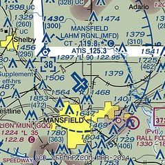
| Sectional chart |
|---|
|
 Download PDF
of official airport diagram from the FAA
| Airport distance calculator |
|---|
|
|
| Sunrise and sunset |
|---|
|
Times for 15-May-2026
| | Local
(UTC-4) | | Zulu
(UTC) |
|---|
| Morning civil twilight | | 05:42 | | 09:42 |
| Sunrise | | 06:14 | | 10:14 |
| Sunset | | 20:39 | | 00:39 |
| Evening civil twilight | | 21:10 | | 01:10 |
|
| Current date and time |
|---|
| Zulu (UTC) | 15-May-2026 07:24:03 |
|---|
| Local (UTC-4) | 15-May-2026 03:24:03 |
|---|
|
| METAR |
|---|
| KMFD | 150652Z AUTO 00000KT 10SM CLR 04/03 A3004 RMK AO2 SLP174 T00440028 $
|
|
| TAF |
|---|
| KMFD | 150537Z 1506/1606 VRB03KT P6SM FEW250 FM151500 21010KT P6SM BKN250 FM160000 17005KT P6SM BKN100
|
|
| NOTAMs |
|---|
NOTAMs are issued by the DoD/FAA and will open in a separate window not controlled by AirNav.
|
|


