FAA INFORMATION EFFECTIVE 16 APRIL 2026
Location
| FAA Identifier: | 13K |
| Lat/Long: | 37-51-05.8180N 096-17-31.2880W
37-51.096967N 096-17.521467W
37.8516161,-96.2920244
(estimated) |
| Elevation: | 1208.1 ft. / 368.2 m (surveyed) |
| Variation: | 02E (2024) |
| From city: | 2 miles N of EUREKA, KS |
| Time zone: | UTC -5 (UTC -6 during Standard Time) |
| Zip code: | 67045 |
Airport Operations
| Airport use: | Open to the public |
| Activation date: | 07/1959 |
| Control tower: | no |
| ARTCC: | KANSAS CITY CENTER |
| FSS: | WICHITA FLIGHT SERVICE STATION |
| NOTAMs facility: | ICT (NOTAM-D service available) |
| Attendance: | IREG |
| Wind indicator: | lighted |
| Segmented circle: | yes |
| Lights: | ACTVT PAPI RWY 18; MIRL RWY 18/36 - CTAF. |
| Beacon: | white-green (lighted land airport)
Operates sunset to sunrise. |
Airport Communications
| CTAF/UNICOM: | 122.8 |
| WX AWOS-3PT: | 120.975 (620-583-2760) |
- APCH/DEP CTL SVC PRVDD BY KANSAS CITY ARTCC (ZKC) ON FREQS 120.2/323.2 (EMPORIA RCAG).
Nearby radio navigation aids
| VOR radial/distance | | VOR name | | Freq | | Var |
|---|
| EMPr187/27.4 | | EMPORIA VORTAC | | 112.80 | | 08E |
Airport Services
| Fuel available: | 100LL |
| Parking: | tiedowns |
| Airframe service: | NONE |
| Powerplant service: | NONE |
| Bottled oxygen: | NONE |
| Bulk oxygen: | NONE |
Runway Information
Runway 18/36
| Dimensions: | 3504 x 60 ft. / 1068 x 18 m |
| Surface: | asphalt, in good condition |
| Weight bearing capacity: | | PCN 3 /F/C/Y/U | | Single wheel: | 8.0 |
|
| Runway edge lights: | medium intensity |
| RUNWAY 18 | | RUNWAY 36 |
| Latitude: | 37-51.323772N | | 37-50.756320N |
| Longitude: | 096-17.419308W | | 096-17.552970W |
| Elevation: | 1206.4 ft. | | 1195.6 ft. |
| Traffic pattern: | left | | left |
| Runway heading: | 189 magnetic, 191 true | | 009 magnetic, 011 true |
| Markings: | nonprecision, in good condition | | numbers only, in good condition |
| Visual slope indicator: | 2-light PAPI on left (3.00 degrees glide path) | | 2-light PAPI on left (3.00 degrees glide path) |
| Runway end identifier lights: | no | | no |
| Touchdown point: | yes, no lights | | yes, no lights |
Runway 8/26
| Dimensions: | 2143 x 55 ft. / 653 x 17 m |
| Surface: | turf |
| Runway edge markings: | WHITE TIRES MARK RY END. |
| RUNWAY 8 | | RUNWAY 26 |
| Latitude: | 37-51.182272N | | 37-51.197775N |
| Longitude: | 096-17.801663W | | 096-17.356783W |
| Elevation: | 1194.6 ft. | | 1208.1 ft. |
| Traffic pattern: | left | | left |
| Runway heading: | 085 magnetic, 087 true | | 265 magnetic, 267 true |
| Markings: | NSTD, in fair condition | | NSTD, in fair condition |
| Runway end identifier lights: | no | | no |
| Touchdown point: | yes, no lights | | yes, no lights |
| Obstructions: | 4 ft. fence, marked
CONTROLLING OBSTN EXCEEDS A 45 DEG SLP. | | none |
Airport Ownership and Management from official FAA records
| Ownership: | Publicly-owned |
| Owner: | CITY OF EUREKA
MEMORIAL HALL
EUREKA, KS 67045
Phone 620-583-6511 |
Additional Remarks
| - | WILDLIFE ON & INVOF ARPT. |
| - | FOR CD CTC KANSAS CITY ARTCC AT 913-254-8508. |
| A58-36 | GROUND DROPS DOWN ABRUPTLY 85 FT FM END OF RY. |
Instrument Procedures
NOTE: All procedures below are presented as PDF files. If you need a reader for these files, you should download the free Adobe Reader.NOT FOR NAVIGATION. Please procure official charts for flight.
FAA instrument procedures published for use from 16 April 2026 at 0901Z to 14 May 2026 at 0900Z.
IAPs - Instrument Approach Procedures |
|---|
| RNAV (GPS) RWY 18 | |
download (215KB) |
| VOR RWY 18 | |
download (197KB) |
| NOTE: Special Alternate Minimums apply | |
download (147KB) |
| NOTE: Special Take-Off Minimums/Departure Procedures apply | |
download (370KB) |
Other nearby airports with instrument procedures:
KEQA - El Dorado/Capt Jack Thomas Memorial Airport (25 nm W)
KEMP - Emporia Municipal Airport (29 nm N)
KUKL - Coffey County Airport (38 nm NE)
3AU - Augusta Municipal Airport (39 nm W)
1K1 - Lloyd Stearman Field Airport (39 nm W)
|
|

Road maps at:
MapQuest
Bing
Google
| Aerial photo |
|---|
WARNING: Photo may not be current or correct
 Photo by David Newcomer
Photo taken 17-Oct-2015
from 4,500 altitude looking southeast.
Photo by David Newcomer
Photo taken 17-Oct-2015
from 4,500 altitude looking southeast.
Do you have a better or more recent aerial photo of Lt. William M. Milliken Airport that you would like to share? If so, please send us your photo.
|
| Sectional chart |
|---|
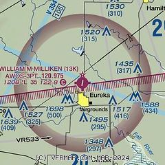
|
| Airport distance calculator |
|---|
|
|
| Sunrise and sunset |
|---|
|
Times for 11-May-2026
| | Local
(UTC-5) | | Zulu
(UTC) |
|---|
| Morning civil twilight | | 05:51 | | 10:51 |
| Sunrise | | 06:20 | | 11:20 |
| Sunset | | 20:23 | | 01:23 |
| Evening civil twilight | | 20:53 | | 01:53 |
|
| Current date and time |
|---|
| Zulu (UTC) | 12-May-2026 02:15:30 |
|---|
| Local (UTC-5) | 11-May-2026 21:15:30 |
|---|
|
| METAR |
|---|
| K13K | 120155Z AUTO 19008KT 10SM CLR 18/07 A3014 RMK AO2 T01820070
|
|
| TAF |
|---|
KCNU
40nm E | 111727Z 1118/1218 19008KT P6SM SKC FM121400 19013G22KT P6SM SKC
|
KIAB
48nm W | 111000Z 1110/1216 VRB06KT 9999 SKC QNH3022INS BECMG 1116/1117 21009KT 9999 SKC QNH3008INS BECMG 1209/1210 18012KT 9999 SKC 520056 QNH3007INS BECMG 1213/1214 20015G25KT 9999 SKC QNH3005INS TX25/1121Z TN09/1111Z
|
|
| NOTAMs |
|---|
NOTAMs are issued by the DoD/FAA and will open in a separate window not controlled by AirNav.
|
|

