FAA INFORMATION EFFECTIVE 19 FEBRUARY 2026
Location
| FAA Identifier: | IAB |
| Lat/Long: | 37-37-23.2175N 097-16-03.4650W
37-37.386958N 097-16.057750W
37.6231160,-97.2676292
(estimated) |
| Elevation: | 1371.5 ft. / 418.0 m (surveyed) |
| Variation: | 04E (2015) |
| From city: | 4 miles S of WICHITA, KS |
| Time zone: | UTC -6 (UTC -5 during Daylight Saving Time) |
| Zip code: | 67221 |
Airport Operations
| Airport use: | Private use, PPR V962-5271. |
| Activation date: | 04/1940 |
| Control tower: | yes |
| ARTCC: | KANSAS CITY CENTER |
| FSS: | WICHITA FLIGHT SERVICE STATION |
| NOTAMs facility: | IAB (NOTAM-D service available) |
| Attendance: | CONTINUOUS |
| Wind indicator: | yes |
| Segmented circle: | no |
| Beacon: | white-green (lighted land airport)
Operates sunset to sunrise. |
Airport Communications
| MC CONNELL GROUND: | 118.0 275.8 |
| MC CONNELL TOWER: | 127.25 291.775 |
| WICHITA APPROACH: | 126.7 ;WEST OF ICT 134.8 134.8 ;EAST OF IAB, 4000 FT & BLW 134.85 ;EAST OF IAB ABV 4000 FT |
| WICHITA DEPARTURE: | 134.8 134.8 ;4000 FT & BLW 134.85 ;ABV 4000 FT |
| COMD POST: | 311.0 323.8 |
| D-ATIS: | 124.65 269.9 |
| EMERG: | 121.5 243.0 |
| PMSV METRO: | 374.2 |
| PTD: | 372.2 |
| SFA: | 269.1 ;BLW 4000 FT 302.2 339.3 351.1 372.9 |
| WX AWOS-3PT at BEC (5 nm NE): | 119.45 (316-515-7116) |
| WX ASOS at AAO (8 nm N): | 134.025 (316-636-2541) |
| WX ASOS at ICT (8 nm W): | PHONE 316-800-1006 |
| WX AWOS-3P at 3AU (9 nm E): | 124.175 (316-733-6696) |
| WX AWOS-2 at 1K1 (12 nm NE): | 118.3 (316-530-6004) |
| WX AWOS-3P at EGT (19 nm S): | 118.875 (620-359-2156) |
- REMOTE BRIEFING SVC AVBL: KANSAS CITY METRO - 369.9.
- TA31 MOBILE RADAR OPERATES 24 HOURS.
- PMSV NOT AVBL WHEN TWR CLSD.
Nearby radio navigation aids
| VOR radial/distance | | VOR name | | Freq | | Var |
|---|
| ICTr109/16.7 | | WICHITA VORTAC | | 113.80 | | 07E |
| HUTr121/38.7 | | HUTCHINSON VOR/DME | | 116.80 | | 04E |
| NDB name | | Hdg/Dist | | Freq | | Var | | ID |
|---|
| PICHE | | 069/9.3 | | 332 | | 04E | | IC | .. -.-. |
Airport Services
| Parking: | hangars |
| Airframe service: | MAJOR |
| Powerplant service: | MAJOR |
| Bottled oxygen: | HIGH/LOW |
| Bulk oxygen: | HIGH/LOW |
Runway Information
Runway 1R/19L
| Dimensions: | 12007 x 150 ft. / 3660 x 46 m |
| Surface: | asphalt/grooved, in fair condition
MID 9500' GROOVED. |
| Weight bearing capacity: | |
| Runway edge lights: | high intensity |
| RUNWAY 1R | | RUNWAY 19L |
| Latitude: | 37-36.406500N | | 37-38.338167N |
| Longitude: | 097-16.242833W | | 097-15.705667W |
| Elevation: | 1336.0 ft. | | 1364.4 ft. |
| Traffic pattern: | left | | left |
| Runway heading: | 008 magnetic, 012 true | | 188 magnetic, 192 true |
| Markings: | precision, in fair condition | | precision, in fair condition |
| Visual slope indicator: | 4-light PAPI on left (3.00 degrees glide path) | | 4-light PAPI on left (3.00 degrees glide path) |
| Approach lights: | SSALR: simplified short approach lighting system with runway alignment indicator lights | | ALSF1: standard 2,400 foot high intensity approach lighting system with centerline sequenced flashers (category I) |
| Runway end identifier lights: | no | | no |
| Touchdown point: | yes, no lights | | yes, no lights |
Runway 1L/19R
| Dimensions: | 12000 x 150 ft. / 3658 x 46 m |
| Surface: | asphalt/concrete |
| Weight bearing capacity: | |
| Runway edge lights: | high intensity |
| RUNWAY 1L | | RUNWAY 19R |
| Latitude: | 37-36.436333N | | 37-38.366833N |
| Longitude: | 097-16.409833W | | 097-15.872667W |
| Elevation: | 1337.6 ft. | | 1371.5 ft. |
| Traffic pattern: | left | | left |
| Runway heading: | 008 magnetic, 012 true | | 188 magnetic, 192 true |
| Markings: | precision | | precision |
| Visual slope indicator: | 4-light PAPI on left (3.00 degrees glide path) | | 4-light PAPI on left (3.00 degrees glide path) |
| RVR equipment: | touchdown | | rollout |
| Approach lights: | ALSF1: standard 2,400 foot high intensity approach lighting system with centerline sequenced flashers (category I) | | ALSF1: standard 2,400 foot high intensity approach lighting system with centerline sequenced flashers (category I) |
| Runway end identifier lights: | no | | no |
| Touchdown point: | yes, no lights | | yes, no lights |
| Instrument approach: | ILS | | ILS |
Airport Ownership and Management from official FAA records
| Ownership: | U.S. Air Force |
| Owner: | USAF
HQ MCCONNELL AFB
WICHITA, KS 67221 |
| Manager: | CHIEF AIRFIELD MANAGEMENT
HQ MCCONNELL AFB
WICHITA, KS 67221
Phone 316-759-3835 |
Additional Remarks
| - | JASU: 4(M32A-86) (MA-1A) (MC-1A) 2(MC-2A) 5(MD-4) 3(AM32-95) |
| - | FUEL: A++ |
| - | OIL: O-133-148-156 SOAP. |
| - | TRAN ALERT: NO PRIORITY BASIS. LTD TRAN MAINT SVC AVBL 1300-0500Z++ WKD; 1400-0000Z++ SAT-SUN; CLSD FED HOL. |
| - | TRANS ALERT: TRAN MAINT NOT AVBL OUTSIDE PUBL HR. TRANS SVC LIMITED. WEAPONS/GUNS, ARM/DE-ARM/SAFEING NOT AVBL. |
| - | REQ FOR PPR TAKEN NO ERYR THAN 7 DAYS PRIOR TO PLANNED MSN. PPR'S VALID +/- 1 HR SKED PPR SLOT TIMES. PPR INCL SKED DV, AIREVAC, AMC AND SAM MSN DUE LTD RAMP SPACE, TRAN ACFT PRK LT. CTC AMOPS DSN 743-3701, C316-759-3701. INBD ACFT WITH DV CTC COMD POST 30 MIN PRIOR TO ETA WITH BLOCK TIME. |
| - | RSTD: INBD ACFT WITH DV CTC COMD POST 30 MIN PRIOR TO ETA WITH BLOCK TIME. DO NOT OVFT MUNITIONS STOR AREA 2500' E OF MIDPOINT RWY 01R-19L. ALL INBD PAX/CARGO ACFT MUST CTC COMD POST NO LATER THAN 30 MIN PRIOR TO LDG.ACFT OPR RSTD DUR BIRD WATCH COND MODERATE (TKOF OR LDG PERMS ONLY WHEN DEP AND ARR RTE AVOID IDENT BIRD ACT. NO LCL IFR/VFR TFC PAT ACT) AND SEVERE (TKOF AND LDG PROH WO OG/CC APVL), CTC ATIS, TWR, COMD POST, OR PTD/AMOPS FOR CURRENT BIRD WATCH COND. |
| - | CAUTION: ACFT MAY APPEAR TO BE LEFT OF CRS WHEN FLYING INST APCH TO RWY 01L IN IMC DUE TO PARL RWY 01R APCH LGT. |
| - | SOAP SVCS NOT AVBL FOR TRANSIENT ACFT. |
| - | TRAN ALERT: PRK SPACE, SVCG, AND RON CANNOT BE ASSURED WITHOUT PRIOR COORD DSN 743-3701, C316-759-3701. GND SVCG NOT AVBL WHEN LIGHTNING WITHIN 5 NM. |
| - | CAUTION: RWY 01R/19L EDGE LIGHTS LCTD MORE THAN 10 FT FR EDGE OF USABLE RWY SFC. |
| - | TRAN ALERT: NO DEICING CAPABILITY FOR C-5, C-17, B-747, KC OR DC-10. |
| - | RWY 01L-19R FULLY GROOVED. RWY 01R-19L: FIRST 1000 FT AND LAST 1000 FT- CONC; MID 10,000 FT- ASPH; MID 9500 FT GROOVED. |
| - | PMSV METRO: WX SVC AVBL H24 UNLESS AFLD CLSD AT DSN 743-3707/4311, C316-759-3707/4311. AN/FMQ-19 AWOS IN USE, AUGMENTED BY HUMAN OBSN WHEN NEC. VIS OF AFLD RSTD FR BASE WX OPS NNE-SE DUR MANUAL AUGMENTATION BY WX FORECASTER. CTC TACC DSN 779-0308, C618-229-0308, OR 26 OWS DSN 331-2651/2652/2653, C318-529-2641/2652/2653 DUR WX FLT CLOSURE OR EVAC. WHEN POSSIBLE, PROVIDE 2 HR ADVANCE NTC FOR ALL RQR BRIEFS. |
| - | CAUTION: BACKUP WX OBSN VIEW LTD, RSTD FR 020-140 BY FLIGHTLINE FAC. ATC PERS IAW COOPERATIVE WX WATCH WILL ALERT WX PERS ON ANY UNREPORTED WX COND THAT COULD AFCT FLT SAFETY. ALTN WX LCTN VIEW LTD, RSTD FR 210-320 BY BLDGS. |
| - | RSTD: HAZ CARGO PRK AVBL WITH 48 HRS PN. |
| - | STOR OF CLASSIFIED MATERIAL NOT AVBL AT AFLD MGMT, CTC COMD POST DSN 743-3251, C316-759-3251, 24 HR PRIOR. |
| - | RSTD: PRACTICE APCH (VFR/IFR) RSTD TO KC-135, KC-46, A10, C-12, T-1, C-130, UH-60 AND T-38 ACFT ONLY 0400-1200Z++. |
| - | MISC: ACFT RESCUE FIRE FIGHTING (ARFF) CAPABILITIES HAS PERM REDUCED LEVEL OF SVC (RLS) FOR USAF CAT 5 AND 6/NFPA CAT 9 AND 10 (ACFT TYPE: C5, VC-25, KC-10 AND E-4). |
| - | KANSAS ANG APRON CLSD, NO ACFT OPS WITHOUT AFLD MGR APVL. |
| - | NVD TRNG EVERY MON AND WED 0300-0830Z++ (MON, WED 2100-0230L). RWY 19L-01R UNAVBL FOR ACFT NOT PARTICIPATING IN NVD OPS. VFR PAT WILL BE CLSD FOR ALL TFC EXC PARTICIPATING ACFT. |
| - | RWYCC NOT RPT. |
| - | (CONTACT TITLE) MR. LENZI CAN BE REACHED AT RICHARD.LENZI@US.AF.MIL |
Instrument Procedures
NOTE: All procedures below are presented as PDF files. If you need a reader for these files, you should download the free Adobe Reader.NOT FOR NAVIGATION. Please procure official charts for flight.
FAA instrument procedures published for use from 19 February 2026 at 0901Z to 19 March 2026 at 0900Z.
IAPs - Instrument Approach Procedures |
|---|
| ILS OR LOC RWY 01L | |
download (90KB) |
| ILS OR LOC RWY 19R | |
download (128KB) |
| RNAV (RNP) Z RWY 01L | |
download (82KB) |
| RNAV (RNP) Z RWY 19R | |
download (85KB) |
| RNAV (GPS) RWY 01R | |
download (83KB) |
| RNAV (GPS) RWY 19L | |
download (87KB) |
| RNAV (GPS) Y RWY 01L | |
download (90KB) |
| RNAV (GPS) Y RWY 19R | |
download (85KB) |
| TACAN RWY 01L | |
download (82KB) |
| TACAN RWY 01R | |
download (81KB) |
| TACAN RWY 19L | |
download (110KB) |
| TACAN RWY 19R | |
download (112KB) |
| NOTE: Special Take-Off Minimums/Departure Procedures apply | |
download (546KB) |
Other nearby airports with instrument procedures:
KCEA - Cessna Aircraft Field Airport (2 nm NE)
KBEC - Beech Factory Airport (5 nm NE)
K50 - Cook Airfield (6 nm SE)
KAAO - Colonel James Jabara Airport (8 nm N)
KICT - Wichita Dwight D Eisenhower National Airport (8 nm W)
3AU - Augusta Municipal Airport (9 nm E)
1K1 - Lloyd Stearman Field Airport (12 nm NE)
KEGT - Wellington Municipal Airport (19 nm S)
|
|

Road maps at:
MapQuest
Bing
Google
| Aerial photo |
|---|
WARNING: Photo may not be current or correct
 Taken in June 2008
Do you have a better or more recent aerial photo of Mc Connell Air Force Base that you would like to share? If so, please send us your photo.
|
| Sectional chart |
|---|
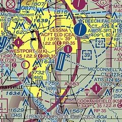
|
 Download PDF
of official airport diagram from the FAA
| Airport distance calculator |
|---|
|
|
| Sunrise and sunset |
|---|
|
Times for 02-Mar-2026
| | Local
(UTC-6) | | Zulu
(UTC) |
|---|
| Morning civil twilight | | 06:34 | | 12:34 |
| Sunrise | | 07:00 | | 13:00 |
| Sunset | | 18:22 | | 00:22 |
| Evening civil twilight | | 18:49 | | 00:49 |
|
| Current date and time |
|---|
| Zulu (UTC) | 02-Mar-2026 08:19:47 |
|---|
| Local (UTC-6) | 02-Mar-2026 02:19:47 |
|---|
|
| METAR |
|---|
| KIAB | 020755Z AUTO 04014KT 10SM OVC005 02/01 A3012 RMK AO2 SLP210 T00170005
|
KBEC
5nm NE | 020755Z AUTO 03013KT 3SM BR OVC004 01/01 A3014 RMK AO2 T00060006
|
KAAO
8nm N | 020754Z AUTO 03010KT 3SM BR OVC004 01/00 A3015 RMK AO2 PRESFR SLP219 T00060000 $
|
KICT
8nm W | 020753Z 03012G20KT 7SM OVC006 01/00 A3016 RMK AO2 SLP219 T00110000 $
|
K3AU
9nm E | 020755Z AUTO 02010KT 7SM OVC005 01/00 A3016 RMK AO2
|
KEGT
19nm S | 020755Z AUTO 01011KT 7SM OVC006 01/01 A3016 RMK AO2 T00150007
|
|
| TAF |
|---|
| KIAB | 020200Z 0202/0308 04012G18KT 9999 OVC010 QNH3015INS BECMG 0203/0204 02010G15KT 9999 BKN006 OVC010 QNH3013INS BECMG 0210/0211 03006KT 6000 BR SCT004 OVC006 QNH3015INS BECMG 0217/0218 VRB06KT 9999 NSW SCT007 OVC015 QNH3012INS BECMG 0223/0224 12009KT 9999 SCT005 BKN007 OVC015 QNH2997INS TX09/0222Z TN01/0212Z
|
KICT
8nm W | 020520Z 0206/0306 03010KT P6SM OVC007 FM021900 11007KT P6SM OVC015 FM030300 12008KT P6SM OVC009
|
|
| NOTAMs |
|---|
NOTAMs are issued by the DoD/FAA and will open in a separate window not controlled by AirNav.
|
|


