FAA INFORMATION EFFECTIVE 14 MAY 2026
Location
| FAA Identifier: | 19M |
| Lat/Long: | 33-07-31.6600N 090-01-32.0050W
33-07.527667N 090-01.533417W
33.1254611,-90.0255569
(estimated) |
| Elevation: | 340 ft. / 103.6 m (surveyed) |
| Variation: | 02E (1985) |
| From city: | 2 miles NE of LEXINGTON, MS |
| Time zone: | UTC -5 (UTC -6 during Standard Time) |
| Zip code: | 39095 |
Airport Operations
| Airport use: | Open to the public |
| Control tower: | no |
| ARTCC: | MEMPHIS CENTER |
| FSS: | GREENWOOD FLIGHT SERVICE STATION |
| NOTAMs facility: | GWO (NOTAM-D service available) |
| Attendance: | UNATNDD |
| Wind indicator: | lighted |
| Segmented circle: | yes |
| Lights: | SS-SR |
| Beacon: | white-green (lighted land airport)
Operates sunset to sunrise. |
Airport Communications
- APCH/DEP SVC PRVDD BY MEMPHIS ARTCC ON FREQS 132.5/259.1 (GREENWOOD RCAG).
Nearby radio navigation aids
| VOR radial/distance | | VOR name | | Freq | | Var |
|---|
| SQSr145/23.9 | | SIDON VORTAC | | 114.70 | | 03E |
Airport Services
| Parking: | tiedowns |
| Airframe service: | NONE |
| Powerplant service: | NONE |
| Bottled oxygen: | NONE |
| Bulk oxygen: | NONE |
Runway Information
Runway 1/19
| Dimensions: | 3199 x 60 ft. / 975 x 18 m |
| Surface: | asphalt, in good condition |
| Weight bearing capacity: | |
| Runway edge lights: | medium intensity |
| RUNWAY 1 | | RUNWAY 19 |
| Latitude: | 33-07.269583N | | 33-07.785917N |
| Longitude: | 090-01.597167W | | 090-01.468700W |
| Elevation: | 324.0 ft. | | 339.0 ft. |
| Traffic pattern: | left | | left |
| Runway heading: | 010 magnetic, 012 true | | 190 magnetic, 192 true |
| Markings: | basic, in fair condition | | basic, in fair condition |
| Visual slope indicator: | 2-light PAPI on left (3.00 degrees glide path) | | 2-light PAPI on left (4.00 degrees glide path) |
| Touchdown point: | yes, no lights | | yes, no lights |
| Obstructions: | 32 ft. trees, 1365 ft. from runway, 50 ft. right of centerline, 36:1 slope to clear | | 41 ft. tree, 1200 ft. from runway, 60 ft. left of centerline, 24:1 slope to clear |
Airport Ownership and Management from official FAA records
| Ownership: | Publicly-owned |
| Owner: | CITY OF LEXINGTON
112 SPRING ST
LEXINGTON, MS 39095
Phone 662-834-1261 |
| Manager: | MAYOR PERCY WASHINGTON
PO BOX 455, 112 SPRING ST
LEXINGTON, MS 39095
Phone 662-834-1261
POLICE DEPT 662-834-3508. |
Additional Remarks
| - | FOR CD CTC MEMPHIS ARTCC AT 901-368-8453/8449. |
Instrument Procedures
NOTE: All procedures below are presented as PDF files. If you need a reader for these files, you should download the free Adobe Reader.NOT FOR NAVIGATION. Please procure official charts for flight.
FAA instrument procedures published for use from 14 May 2026 at 0901Z to 11 June 2026 at 0900Z.
IAPs - Instrument Approach Procedures |
|---|
| VOR/DME OR GPS-A | |
download (182KB) |
| NOTE: Special Take-Off Minimums/Departure Procedures apply | |
download (116KB) |
Other nearby airports with instrument procedures:
KGWO - Greenwood-Leflore Airport (22 nm N)
KOSX - Kosciusko-Attala County Airport (24 nm E)
5A6 - Winona-Montgomery County Airport (25 nm NE)
87I - Yazoo County Airport (26 nm SW)
KIDL - Indianola Municipal Airport (39 nm NW)
|
|

Road maps at:
MapQuest
Bing
Google
| Aerial photo |
|---|
WARNING: Photo may not be current or correct

Do you have a better or more recent aerial photo of C A Moore Airport that you would like to share? If so, please send us your photo.
|
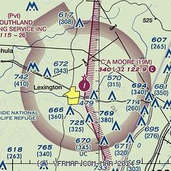
| Sectional chart |
|---|
|
| Airport distance calculator |
|---|
|
|
| Sunrise and sunset |
|---|
|
Times for 18-May-2026
| | Local
(UTC-5) | | Zulu
(UTC) |
|---|
| Morning civil twilight | | 05:32 | | 10:32 |
| Sunrise | | 05:59 | | 10:59 |
| Sunset | | 19:54 | | 00:54 |
| Evening civil twilight | | 20:21 | | 01:21 |
|
| Current date and time |
|---|
| Zulu (UTC) | 18-May-2026 05:41:07 |
|---|
| Local (UTC-5) | 18-May-2026 00:41:07 |
|---|
|
| METAR |
|---|
KGWO
23nm N | 180353Z AUTO 17007KT 10SM OVC070 26/21 A3001 RMK AO2 SLP161 T02560211
|
K5A6
25nm NE | 180415Z AUTO 17005KT 10SM SCT060 BKN070 24/21 A3003 RMK AO2 T02420208
|
KMBO
41nm S | 180415Z AUTO 16003KT 10SM CLR 23/22 A3003 RMK AO2
|
|
| TAF |
|---|
KGWO
23nm N | 171720Z 1718/1818 18008KT P6SM FEW250
|
|
| NOTAMs |
|---|
NOTAMs are issued by the DoD/FAA and will open in a separate window not controlled by AirNav.
|
|

