FAA INFORMATION EFFECTIVE 14 MAY 2026
Location
| FAA Identifier: | 5A6 |
| Lat/Long: | 33-27-53.9560N 089-43-48.7830W
33-27.899267N 089-43.813050W
33.4649878,-89.7302175
(estimated) |
| Elevation: | 363.8 ft. / 110.9 m (surveyed) |
| Variation: | 01W (2010) |
| From city: | 1 mile S of WINONA, MS |
| Time zone: | UTC -5 (UTC -6 during Standard Time) |
| Zip code: | 38967 |
Airport Operations
| Airport use: | Open to the public |
| Activation date: | 09/1942 |
| Control tower: | no |
| ARTCC: | MEMPHIS CENTER |
| FSS: | GREENWOOD FLIGHT SERVICE STATION |
| NOTAMs facility: | GWO (NOTAM-D service available) |
| Attendance: | CONTINUOUS |
| Wind indicator: | lighted |
| Segmented circle: | yes |
| Lights: | ACTVT PAPI RWY 03 & 21; MIRL RWY 3/21 - CTAF. MIRL OPR DUSK-2200. |
| Beacon: | white-green (lighted land airport)
Operates sunset to sunrise. |
Airport Communications
| CTAF: | 122.9 |
| WX AWOS-3PT: | 120.175 (662-283-2172) |
| WX ASOS at GWO (18 nm W): | 119.975 (662-453-3304) |
- APCH/DEP SVC PRVDD BY MEMPHIS ARTCC ON FREQS 128.5/279.55 (TUPELO RCAG).
Nearby radio navigation aids
| VOR radial/distance | | VOR name | | Freq | | Var |
|---|
| SQSr087/27.4 | | SIDON VORTAC | | 114.70 | | 03E |
Airport Services
| Fuel available: | 100LL
100LL:FUEL 24 HR CREDIT CARD SVC AVBL. |
| Parking: | tiedowns |
| Airframe service: | MINOR
AVBL IN EMERG OR WITH PN 662-283-9833. |
| Powerplant service: | MINOR
AVBL IN EMERG OR WITH PN 662-283-9833. |
| Bottled oxygen: | NONE |
| Bulk oxygen: | NONE |
Runway Information
Runway 3/21
| Dimensions: | 4000 x 60 ft. / 1219 x 18 m |
| Surface: | asphalt, in good condition |
| Weight bearing capacity: | |
| Runway edge lights: | medium intensity |
| RUNWAY 3 | | RUNWAY 21 |
| Latitude: | 33-27.609967N | | 33-28.188567N |
| Longitude: | 089-44.001883W | | 089-43.624183W |
| Elevation: | 347.5 ft. | | 363.8 ft. |
| Traffic pattern: | left | | left |
| Runway heading: | 030 magnetic, 029 true | | 210 magnetic, 209 true |
| Markings: | basic, in good condition | | basic, in good condition |
| Visual slope indicator: | 2-light PAPI on left (4.00 degrees glide path) | | 2-light PAPI on left (4.00 degrees glide path) |
| Touchdown point: | yes, no lights | | yes, no lights |
| Obstructions: | 44 ft. trees, 1300 ft. from runway, 225 ft. left of centerline, 25:1 slope to clear | | 49 ft. trees, 1455 ft. from runway, 100 ft. right of centerline, 25:1 slope to clear |
Airport Ownership and Management from official FAA records
| Ownership: | Publicly-owned |
| Owner: | WINONA CITY & MONTGOMERY COUNTY
PO BOX 29, 217 AIRPORT DR
WINONA, MS 38967
Phone 662-283-1232 |
| Manager: | BRENT RICHARDSON
217 AIRPORT DR
WINONA, MS 38967
Phone 662-417-4417 |
Additional Remarks
| - | FOR CD CTC MEMPHIS ARTCC AT 901-368-8453/8449. |
Instrument Procedures
NOTE: All procedures below are presented as PDF files. If you need a reader for these files, you should download the free Adobe Reader.NOT FOR NAVIGATION. Please procure official charts for flight.
FAA instrument procedures published for use from 14 May 2026 at 0901Z to 11 June 2026 at 0900Z.
IAPs - Instrument Approach Procedures |
|---|
| RNAV (GPS) RWY 03 | |
download (179KB) |
| RNAV (GPS) RWY 21 | |
download (208KB) |
| NOTE: Special Take-Off Minimums/Departure Procedures apply | |
download (194KB) |
Other nearby airports with instrument procedures:
KGWO - Greenwood-Leflore Airport (18 nm W)
KGNF - Grenada Municipal Airport (22 nm N)
KOSX - Kosciusko-Attala County Airport (24 nm SE)
19M - C A Moore Airport (25 nm SW)
KLMS - Louisville/Winston County Airport (39 nm SE)
|
|

Road maps at:
MapQuest
Bing
Google
| Aerial photo |
|---|
WARNING: Photo may not be current or correct

Do you have a better or more recent aerial photo of Winona-Montgomery County Airport that you would like to share? If so, please send us your photo.
|
| Sectional chart |
|---|
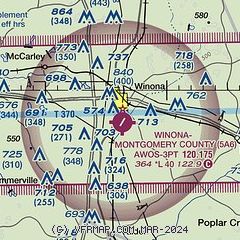
|
| Airport distance calculator |
|---|
|
|
| Sunrise and sunset |
|---|
|
Times for 28-May-2026
| | Local
(UTC-5) | | Zulu
(UTC) |
|---|
| Morning civil twilight | | 05:24 | | 10:24 |
| Sunrise | | 05:52 | | 10:52 |
| Sunset | | 20:00 | | 01:00 |
| Evening civil twilight | | 20:28 | | 01:28 |
|
| Current date and time |
|---|
| Zulu (UTC) | 28-May-2026 12:32:17 |
|---|
| Local (UTC-5) | 28-May-2026 07:32:17 |
|---|
|
| METAR |
|---|
| K5A6 | 281215Z AUTO 10SM BKN005 OVC010 23/22 A2997 RMK AO2 T02310223
|
KGWO
18nm W | 281222Z AUTO 00000KT 10SM FEW007 SCT035 OVC090 24/23 A2996 RMK AO2 T02390228
|
|
| TAF |
|---|
KGWO
18nm W | 281123Z 2812/2912 09003KT P6SM OVC005 FM281430 12003KT P6SM OVC015 FM281600 13006KT P6SM BKN050 TEMPO 2823/2903 4SM -TSRA OVC050CB FM290700 16003KT P6SM OVC015
|
|
| NOTAMs |
|---|
NOTAMs are issued by the DoD/FAA and will open in a separate window not controlled by AirNav.
|
|

