FAA INFORMATION EFFECTIVE 16 APRIL 2026
Location
| FAA Identifier: | 1B8 |
| Lat/Long: | 43-03-09.7000N 073-21-47.3000W
43-03.161667N 073-21.788333W
43.0526944,-73.3631389
(estimated) |
| Elevation: | 510 ft. / 155 m (estimated) |
| Variation: | 14W (1985) |
| From city: | 2 miles N of CAMBRIDGE, NY |
| Time zone: | UTC -4 (UTC -5 during Standard Time) |
| Zip code: | 12816 |
Airport Operations
| Airport use: | Open to the public |
| Activation date: | 07/1966 |
| Control tower: | no |
| ARTCC: | BOSTON CENTER |
| FSS: | BURLINGTON FLIGHT SERVICE STATION |
| NOTAMs facility: | BTV (NOTAM-D service available) |
| Attendance: | UNATNDD |
| Wind indicator: | yes |
| Segmented circle: | no |
Airport Communications
| CTAF: | 122.9 |
| WX ASOS at DDH (11 nm SE): | 135.925 (802-442-6059) |
Nearby radio navigation aids
| VOR radial/distance | | VOR name | | Freq | | Var |
|---|
| CAMr001/3.6 | | CAMBRIDGE VOR/DME | | 115.00 | | 14W |
| ALBr060/26.6 | | ALBANY VORTAC | | 115.30 | | 13W |
| NDB name | | Hdg/Dist | | Freq | | Var | | ID |
|---|
| HUNTER | | 079/27.7 | | 356 | | 14W | | HEU | .... . ..- |
Airport Services
| Parking: | tiedowns |
| Airframe service: | NONE |
| Powerplant service: | NONE |
Runway Information
Runway 5/23
| Dimensions: | 2130 x 65 ft. / 649 x 20 m
WID VARIES FM 65-80 FT BASED ON MOWING. |
| Surface: | turf, in good condition
& RWY 07/25 SOFT & WET MAR-JUN. |
| RUNWAY 5 | | RUNWAY 23 |
| Latitude: | 43-03.012688N | | 43-03.310805N |
| Longitude: | 073-21.913578W | | 073-21.661648W |
| Elevation: | 508.0 ft. | | 510.0 ft. |
| Traffic pattern: | left | | left |
| Runway heading: | 046 magnetic, 032 true | | 226 magnetic, 212 true |
| Obstructions: | 86 ft. tree, 723 ft. from runway, 102 ft. left of centerline, 8:1 slope to clear | | 86 ft. trees, 29 ft. from runway, 96 ft. right of centerline, 1:1 slope to clear |
Runway 7/25
| Dimensions: | 2100 x 63 ft. / 640 x 19 m |
| Surface: | turf, in good condition |
| Runway edge markings: | RWY 07 & 25: DTHR MKD WITH CONES. |
| RUNWAY 7 | | RUNWAY 25 |
| Traffic pattern: | left | | left |
| Displaced threshold: | 222 ft. | | 306 ft. |
| Markings: | NSTD | | NSTD |
| Runway end identifier lights: | no | | |
| Obstructions: | 28 ft. rr, 21 ft. from runway, 55 ft. left of centerline, 1:1 slope to clear
23 FT RR, 55 FT LT; X EXTND RWY CNTRLN 21 FT FM RWY END. 8:1 SLP TO DTHR. | | 60 ft. road, 153 ft. from runway, 107 ft. left of centerline, 2:1 slope to clear
7:1 SLP TO DTHR. 14 FT HANGAR, 0 FT FM RWY END, 66 FT RIGHT. 99FT TREES; 113 FT LEFT, 14 FT FM RWY END. |
Airport Ownership and Management from official FAA records
| Ownership: | Privately-owned |
| Owner: | DEAN CHAPIN
PO BOX 144
CAMBRIDGE, NY 12816
Phone (518) 677-8866 |
| Manager: | GEORGE GRACEY
6 MYRTLE AVE.
CAMBRIDGE, NY 12816
Phone (518) 727-6509 |
Additional Remarks
| - | LGTD 5 FT FENCE AT RWY 25 END. |
| - | FOR CD CTC ALBANY APCH AT 518-862-2299. |
Instrument Procedures
There are no published instrument procedures at 1B8.
Some nearby airports with instrument procedures:
KDDH - William H Morse State Airport (11 nm SE)
KGFL - Floyd Bennett Memorial Airport (20 nm NW)
5B2 - Saratoga County Airport (22 nm W)
KAQW - Harriman-and-West Airport (23 nm S)
KALB - Albany International Airport (27 nm SW)
|
|

Road maps at:
MapQuest
Bing
Google
| Aerial photo |
|---|
WARNING: Photo may not be current or correct
 Photo taken 13-Oct-2013
looking east.
Photo taken 13-Oct-2013
looking east.
Do you have a better or more recent aerial photo of Chapin Field Airport that you would like to share? If so, please send us your photo.
|
| Sectional chart |
|---|
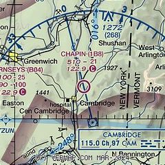
|
| Airport distance calculator |
|---|
|
|
| Sunrise and sunset |
|---|
|
Times for 04-May-2026
| | Local
(UTC-4) | | Zulu
(UTC) |
|---|
| Morning civil twilight | | 05:13 | | 09:13 |
| Sunrise | | 05:44 | | 09:44 |
| Sunset | | 19:56 | | 23:56 |
| Evening civil twilight | | 20:28 | | 00:28 |
|
| Current date and time |
|---|
| Zulu (UTC) | 04-May-2026 10:28:20 |
|---|
| Local (UTC-4) | 04-May-2026 06:28:20 |
|---|
|
| METAR |
|---|
KDDH
11nm SE | 040954Z AUTO 00000KT 10SM FEW120 04/01 A2981 RMK AO2 SLP095 T00440006 $
|
KGFL
20nm NW | 040953Z AUTO 21005KT 10SM OVC075 08/02 A2979 RMK AO2 SLP090 T00780017
|
|
| TAF |
|---|
KGFL
20nm NW | 040523Z 0406/0506 22005KT P6SM OVC060 WS020/25035KT PROB30 0407/0411 6SM -SHRA OVC040 FM041300 22012G20KT P6SM BKN080 FM041800 23013G24KT P6SM SCT080 BKN250 FM050000 21007KT P6SM SCT250
|
|
| NOTAMs |
|---|
NOTAMs are issued by the DoD/FAA and will open in a separate window not controlled by AirNav.
|
|

