FAA INFORMATION EFFECTIVE 14 MAY 2026
Location
| FAA Identifier: | 1S5 |
| Lat/Long: | 46-19-37.4600N 119-58-13.3040W
46-19.624333N 119-58.221733W
46.3270722,-119.9703622
(estimated) |
| Elevation: | 768 ft. / 234.1 m (surveyed) |
| Variation: | 19E (1985) |
| From city: | 2 miles E of SUNNYSIDE, WA |
| Time zone: | UTC -7 (UTC -8 during Standard Time) |
| Zip code: | 98944 |
Airport Operations
| Airport use: | Open to the public |
| Activation date: | 05/1947 |
| Control tower: | no |
| ARTCC: | SEATTLE CENTER |
| FSS: | SEATTLE FLIGHT SERVICE STATION |
| NOTAMs facility: | 1S5 (NOTAM-D service available) |
| Attendance: | UNATNDD |
| Wind indicator: | lighted |
| Segmented circle: | yes |
| Beacon: | white-green (lighted land airport)
Operates sunset to sunrise. |
Airport Communications
| CTAF: | 122.9 |
| WX AWOS-3PT: | 123.675 (509-836-2384) |
| WX AWOS-1 at S40 (10 nm SE): | 121.125 (509-786-8889) |
Nearby radio navigation aids
| VOR radial/distance | | VOR name | | Freq | | Var |
|---|
| YKMr106/24.4 | | YAKIMA VORTAC | | 116.00 | | 21E |
| PSCr261/35.5 | | PASCO VOR/DME | | 113.75 | | 15E |
Airport Services
| Fuel available: | 100LL |
| Parking: | tiedowns |
| Bottled oxygen: | NONE |
| Bulk oxygen: | NONE |
Runway Information
Runway 7/25
| Dimensions: | 3425 x 60 ft. / 1044 x 18 m |
| Surface: | asphalt, in good condition |
| Weight bearing capacity: | |
| Runway edge lights: | low intensity |
| RUNWAY 7 | | RUNWAY 25 |
| Latitude: | 46-19.625965N | | 46-19.622862N |
| Longitude: | 119-58.628437W | | 119-57.815032W |
| Elevation: | 745.7 ft. | | 767.7 ft. |
| Traffic pattern: | left | | left |
| Runway heading: | 071 magnetic, 090 true | | 251 magnetic, 270 true |
| Markings: | basic, in good condition | | basic, in good condition |
| Touchdown point: | yes, no lights | | yes, no lights |
| Obstructions: | 15 ft. road, 331 ft. from runway, 8:1 slope to clear | | 46 ft. pole, 1437 ft. from runway, 21 ft. right of centerline, 26:1 slope to clear
RWY 25 ACES RD 80 FT FM END OF RWY. |
Airport Ownership and Management from official FAA records
| Ownership: | Publicly-owned |
| Owner: | CITY OF SUNNYSIDE
CITY HALL, 818 EAST EDISON AVENUE
SUNNYSIDE, WA 98944
Phone 509-837-5399 |
| Manager: | RAUL SANCHEZ
818 EAST EDISON AVENUE
SUNNYSIDE, WA 98944
Phone 509-837-5399 |
Additional Remarks
| - | ALL ARPT PROPERTY IS USED FOR AGRI PURPOSES WI 20' OF RY. |
| - | RETRO-REFLECTIVE DEVICES ALONG TWYS. |
| - | FOR CD CTC SPOKANE APCH AT 509-742-2525, WHEN APCH CLSD CTC SEATTLE ARTCC AT 253-351-3694. |
| - | MIGRATORY GEESE. |
Instrument Procedures
There are no published instrument procedures at 1S5.
Some nearby airports with instrument procedures:
KRLD - Richland Airport (28 nm E)
KYKM - Yakima Air Terminal/McAllister Field (28 nm NW)
KPSC - Tri-Cities Airport (35 nm E)
KHRI - Hermiston Municipal Airport (42 nm SE)
KELN - Bowers Field Airport (48 nm NW)
|
|

Road maps at:
MapQuest
Bing
Google
| Aerial photo |
|---|
WARNING: Photo may not be current or correct
 Photo by Lesley Porter
Photo taken 29-Sep-2006
from a Super Cub
Photo by Lesley Porter
Photo taken 29-Sep-2006
from a Super Cub
Do you have a better or more recent aerial photo of Sunnyside Municipal Airport that you would like to share? If so, please send us your photo.
|
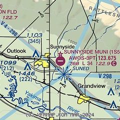
| Sectional chart |
|---|
|
| Airport distance calculator |
|---|
|
|
| Sunrise and sunset |
|---|
|
Times for 10-Jun-2026
| | Local
(UTC-7) | | Zulu
(UTC) |
|---|
| Morning civil twilight | | 04:30 | | 11:30 |
| Sunrise | | 05:09 | | 12:09 |
| Sunset | | 20:50 | | 03:50 |
| Evening civil twilight | | 21:29 | | 04:29 |
|
| Current date and time |
|---|
| Zulu (UTC) | 11-Jun-2026 02:01:35 |
|---|
| Local (UTC-7) | 10-Jun-2026 19:01:35 |
|---|
|
| TAF |
|---|
KYKM
27nm NW | 101720Z 1018/1118 31012G18KT P6SM FEW070 FM110000 30009KT P6SM SKC
|
|
| NOTAMs |
|---|
NOTAMs are issued by the DoD/FAA and will open in a separate window not controlled by AirNav.
|
|

