FAA INFORMATION EFFECTIVE 14 MAY 2026
Location
| FAA Identifier: | 2S0 |
| Lat/Long: | 48-21-02.1070N 120-05-38.2230W
48-21.035117N 120-05.637050W
48.3505853,-120.0939508
(estimated) |
| Elevation: | 1602 ft. / 488 m (estimated) |
| Variation: | 20E (1985) |
| From city: | 1 mile SE of TWISP, WA |
| Time zone: | UTC -7 (UTC -8 during Standard Time) |
| Zip code: | 98856 |
Airport Operations
| Airport use: | Open to the public |
| Activation date: | 10/1945 |
| Control tower: | no |
| ARTCC: | SEATTLE CENTER |
| FSS: | SEATTLE FLIGHT SERVICE STATION |
| NOTAMs facility: | SEA (NOTAM-D service available) |
| Attendance: | UNATNDD |
| Wind indicator: | yes |
| Segmented circle: | no |
| Lights: | ACTVT MIRL RY 10/28 & PAPI RY 28 - CTAF. |
| Beacon: | white-green (lighted land airport)
ACTVT ROTG BCN - CTAF. |
Airport Communications
| CTAF: | 122.9 |
| WX AWOS-3 at S52 (5 nm NW): | 118.425 (509-997-0142) |
Airport Services
| Parking: | tiedowns |
| Airframe service: | NONE |
| Powerplant service: | NONE |
Runway Information
Runway 10/28
| Dimensions: | 2701 x 60 ft. / 823 x 18 m |
| Surface: | asphalt/concrete, in fair condition |
| Runway edge lights: | medium intensity |
| RUNWAY 10 | | RUNWAY 28 |
| Latitude: | 48-21.140600N | | 48-20.929633N |
| Longitude: | 120-05.930350W | | 120-05.343750W |
| Traffic pattern: | left | | left |
| Displaced threshold: | no | | 200 ft.
DSPLCD THR MARKED BY LIGHT FIXTURE. |
| Markings: | basic, in fair condition | | basic, in fair condition |
| Visual slope indicator: | | | 2-light PAPI on left (4.00 degrees glide path) |
| Obstructions: | 30 ft. trees, 290 ft. from runway, 3:1 slope to clear
+4 FT BRUSH & CLIFF WI 200 FT OF THR. | | 38 ft. trees, 380 ft. from runway, 4:1 slope to clear
ROAD 15 FT HI, 127 FT FM THR; ROAD 80 FT L, 15 FT HI; TREE 112 FT L, 30 FT HI; TREE 123 FT L, 55 FT FM THR. |
Airport Ownership and Management from official FAA records
| Ownership: | Publicly-owned |
| Owner: | TOWN OF TWISP
P.O. BOX 278, TOWN HALL, 118 S GLOVER
TWISP, WA 98856
Phone 509-997-4081 |
| Manager: | ANDREW DURHAM
P.O. BOX 278
TWISP, WA 98856
Phone (509) 997-1311 |
Additional Remarks
| - | DEER & PEDESTRIANS ON & INVOF ARPT. |
| - | TREES; FENCE; ROAD IN PRIM SFC. |
| - | MOUNTAINOUS TERRAIN SURROUNDS AIRPORT. |
| - | ARPT CTAF FREQ 122.9; ANOTHER AIRPORT, METHOW VALLEY STATE (S52) WITHIN 8 NM CTAF FREQ 122.8. |
| - | FOR CD CTC SEATTLE ARTCC AT 253-351-3694. |
| - | FOR OKANOGAN MOA A AND B, FREQ 126.1 |
Instrument Procedures
There are no published instrument procedures at 2S0.
Some nearby airports with instrument procedures:
KOMK - Omak Airport (24 nm E)
3W7 - Grand Coulee Dam Airport (48 nm SE)
KEAT - Pangborn Memorial Airport (57 nm S)
2S8 - Wilbur Airport (65 nm SE)
KEPH - Ephrata Municipal Airport (67 nm S)
|
|

Road maps at:
MapQuest
Bing
Google
| Aerial photo |
|---|
WARNING: Photo may not be current or correct
 Photo by Fred Wert
Photo taken 20-Jun-2011
looking northwest.
Photo by Fred Wert
Photo taken 20-Jun-2011
looking northwest.
Do you have a better or more recent aerial photo of Twisp Municipal Airport that you would like to share? If so, please send us your photo.
|
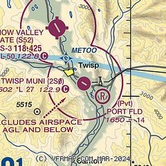
| Sectional chart |
|---|
|
| Airport distance calculator |
|---|
|
|
| Sunrise and sunset |
|---|
|
Times for 29-May-2026
| | Local
(UTC-7) | | Zulu
(UTC) |
|---|
| Morning civil twilight | | 04:27 | | 11:27 |
| Sunrise | | 05:07 | | 12:07 |
| Sunset | | 20:49 | | 03:49 |
| Evening civil twilight | | 21:29 | | 04:29 |
|
| Current date and time |
|---|
| Zulu (UTC) | 29-May-2026 23:25:11 |
|---|
| Local (UTC-7) | 29-May-2026 16:25:11 |
|---|
|
| METAR |
|---|
KS52
5nm NW | 292255Z AUTO 35005KT 10SM SCT070 OVC100 16/08 A2985 RMK AO2 T01600084
|
|
| NOTAMs |
|---|
NOTAMs are issued by the DoD/FAA and will open in a separate window not controlled by AirNav.
|
|

