FAA INFORMATION EFFECTIVE 16 APRIL 2026
Location
| FAA Identifier: | EPH |
| Lat/Long: | 47-18-29.0580N 119-31-00.8890W
47-18.484300N 119-31.014817W
47.3080717,-119.5169136
(estimated) |
| Elevation: | 1276.2 ft. / 389.0 m (surveyed) |
| Variation: | 16E (2010) |
| From city: | 2 miles SE of EPHRATA, WA |
| Time zone: | UTC -7 (UTC -8 during Standard Time) |
| Zip code: | 98823 |
Airport Operations
| Airport use: | Open to the public |
| Activation date: | 08/1943 |
| Control tower: | no |
| ARTCC: | SEATTLE CENTER |
| FSS: | SEATTLE FLIGHT SERVICE STATION |
| NOTAMs facility: | EPH (NOTAM-D service available) |
| Attendance: | MON-FRI 0700-1600 |
| Wind indicator: | lighted |
| Segmented circle: | yes |
| Lights: | ACTVT REIL RWYS 3, 11, 21 & 29; MIRL RWY 03/21 & MIRL RWY 11/29 - CTAF. PAPI RWY 29, RWY 03 & RWY 21 OPR CONSLY. |
| Beacon: | white-green (lighted land airport)
Operates sunset to sunrise. |
| Taxiway lights: | REFLECTORS ON PORTIONS OF TWYS. |
Airport Communications
| CTAF/UNICOM: | 122.8 |
| WX ASOS: | 135.775 (509-754-3761) |
| GRANT COUNTY APPROACH: | 126.4 |
| GRANT COUNTY DEPARTURE: | 126.4 |
| IC: | 126.4 |
| WX ASOS at MWH (10 nm SE): | 119.05 (509-762-5082) |
- UNICOM MNTD INTMTLY.
- APCH/DEP CTL SVC PRVDD BY SEATTLE ARTCC (ZSE) ON FREQS 126.1/291.6 (MARLIN RCAG) WHEN GRANT COUNTY APCH CTL (MWH)CLSD.
Nearby radio navigation aids
| VOR radial/distance | | VOR name | | Freq | | Var |
|---|
| EPHr201/5.6 | | EPHRATA VORTAC | | 112.60 | | 21E |
| MWHr288/10.0 | | MOSES LAKE VOR/DME | | 115.00 | | 18E |
| EATr086/28.7 | | WENATCHEE VOR/DME | | 114.35 | | 15E |
Airport Services
| Fuel available: | 100LL JET-A JET-A+
100LL:FUEL 24 HR CREDIT CARD SVC AVBL.
A+:JET-A W/ ADDITIVE AVBL SEVEN DAYS A WEEK 1500Z-2300Z
A:JET-A AVBL SEVEN DAYS A WEEK 1500Z-2300Z. |
| Parking: | hangars and tiedowns |
| Airframe service: | MINOR |
| Powerplant service: | MINOR |
| Bottled oxygen: | NONE |
Runway Information
Runway 3/21
| Dimensions: | 5500 x 75 ft. / 1676 x 23 m |
| Surface: | asphalt, in good condition |
| Weight bearing capacity: | | Single wheel: | 30.0 | | Double wheel: | 60.0 |
|
| Runway edge lights: | medium intensity |
| RUNWAY 3 | | RUNWAY 21 |
| Latitude: | 47-18.351833N | | 47-19.016500N |
| Longitude: | 119-31.314167W | | 119-30.411833W |
| Elevation: | 1261.4 ft. | | 1275.5 ft. |
| Traffic pattern: | right | | left |
| Runway heading: | 027 magnetic, 043 true | | 207 magnetic, 223 true |
| Markings: | nonprecision, in good condition | | nonprecision, in good condition |
| Visual slope indicator: | 4-light PAPI on left (3.00 degrees glide path) | | 4-light PAPI on left (3.00 degrees glide path) |
| Runway end identifier lights: | yes | | yes |
| Touchdown point: | yes, no lights | | yes, no lights |
| Obstructions: | 58 ft. gnd, 2450 ft. from runway, 550 ft. left of centerline, 38:1 slope to clear | | none |
Runway 11/29
| Dimensions: | 3843 x 60 ft. / 1171 x 18 m |
| Surface: | asphalt, in good condition |
| Weight bearing capacity: | |
| Runway edge lights: | medium intensity |
| RUNWAY 11 | | RUNWAY 29 |
| Latitude: | 47-18.277330N | | 47-17.890725N |
| Longitude: | 119-31.438280W | | 119-30.703200W |
| Elevation: | 1261.3 ft. | | 1257.3 ft. |
| Traffic pattern: | left | | left |
| Runway heading: | 112 magnetic, 128 true | | 292 magnetic, 308 true |
| Markings: | basic, in good condition | | basic, in good condition |
| Visual slope indicator: | | | 2-light PAPI on left (3.00 degrees glide path) |
| Runway end identifier lights: | yes | | yes |
| Touchdown point: | yes, no lights | | yes, no lights |
| Obstructions: | 52 ft. gnd, 1666 ft. from runway, 293 ft. left of centerline, 28:1 slope to clear | | none |
Runway 4/22
| Dimensions: | 3467 x 150 ft. / 1057 x 46 m |
| Surface: | asphalt, in fair condition |
| Weight bearing capacity: | |
| Operational restrictions: | RWY 04/22 GLDS USE 1 APR TO 1 NOV. |
| RUNWAY 4 | | RUNWAY 22 |
| Latitude: | 47-18.400833N | | 47-18.821000N |
| Longitude: | 119-31.477167W | | 119-30.910167W |
| Elevation: | 1260.9 ft. | | 1261.5 ft. |
| Traffic pattern: | left | | right |
| Runway heading: | 026 magnetic, 042 true | | 206 magnetic, 222 true |
| Markings: | none, in fair condition | | none, in fair condition |
Airport Ownership and Management from official FAA records
| Ownership: | Publicly-owned |
| Owner: | PORT DIST NO 9 GRANT CO
PORT OF EPHRATA PO BOX 1089
EPHRATA, WA 98823
Phone 509-754-3508 |
| Manager: | DAVID LANMAN
PO BOX 1089
EPHRATA, WA 98823
Phone 509-754-3508 |
Additional Remarks
| - | BE ALERT AEROBATIC ACFT ACTIVITY OVER CENTER OF AIRPORT. |
| - | CONDS NOT MNT MON-FRI 1600-0700, CONDS NOT MNT SAT-SUN & HOLS 1600-0700. |
| - | FOR CD IF UNA TO CTC ON FSS FREQ, CTC GRANT COUNTY APCH AT 509-762-2842. WHEN APCH CLSD CTC SEATTLE ARTCC AT 253-351-3694. |
Instrument Procedures
NOTE: All procedures below are presented as PDF files. If you need a reader for these files, you should download the free Adobe Reader.NOT FOR NAVIGATION. Please procure official charts for flight.
FAA instrument procedures published for use from 16 April 2026 at 0901Z to 14 May 2026 at 0900Z.
IAPs - Instrument Approach Procedures |
|---|
| RNAV (GPS) RWY 03 | |
download (241KB) |
| RNAV (GPS) RWY 21 | |
download (232KB) |
| VOR RWY 21 | |
download (249KB) |
| NOTE: Special Alternate Minimums apply | |
download (177KB) |
| NOTE: Special Take-Off Minimums/Departure Procedures apply | |
download (223KB) |
Other nearby airports with instrument procedures:
KMWH - Grant County International Airport (10 nm SE)
KEAT - Pangborn Memorial Airport (29 nm W)
3W7 - Grand Coulee Dam Airport (41 nm NE)
2S8 - Wilbur Airport (41 nm NE)
KELN - Bowers Field Airport (44 nm W)
|
|

Road maps at:
MapQuest
Bing
Google
| Aerial photo |
|---|
WARNING: Photo may not be current or correct
 Photo by Michael Wren.
Photo taken 30-Apr-2009
Photo by Michael Wren.
Photo taken 30-Apr-2009
Do you have a better or more recent aerial photo of Ephrata Municipal Airport that you would like to share? If so, please send us your photo.
|
| Sectional chart |
|---|
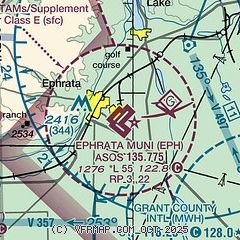
|
| Airport distance calculator |
|---|
|
|
| Sunrise and sunset |
|---|
|
Times for 04-May-2026
| | Local
(UTC-7) | | Zulu
(UTC) |
|---|
| Morning civil twilight | | 05:03 | | 12:03 |
| Sunrise | | 05:38 | | 12:38 |
| Sunset | | 20:12 | | 03:12 |
| Evening civil twilight | | 20:47 | | 03:47 |
|
| Current date and time |
|---|
| Zulu (UTC) | 04-May-2026 19:01:40 |
|---|
| Local (UTC-7) | 04-May-2026 12:01:40 |
|---|
|
| METAR |
|---|
| KEPH | 041853Z AUTO 36015G23KT 10SM CLR 29/01 A2976 RMK AO2 PK WND 35026/1826 SLP068 T02890011
|
KMWH
10nm SE | 041852Z 01012G23KT 10SM CLR 29/01 A2977 RMK AO2 PK WND 36026/1804 SLP074 T02940006
|
|
| TAF |
|---|
KMWH
10nm SE | 041728Z 0418/0518 01013G20KT P6SM SKC FM050300 01007KT P6SM FEW100
|
|
| NOTAMs |
|---|
NOTAMs are issued by the DoD/FAA and will open in a separate window not controlled by AirNav.
|
|

