FAA INFORMATION EFFECTIVE 16 APRIL 2026
Location
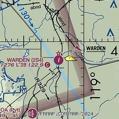
| FAA Identifier: | 2S4 |
| Lat/Long: | 46-57-56.9348N 119-03-58.7942W
46-57.948913N 119-03.979903W
46.9658152,-119.0663317
(estimated) |
| Elevation: | 1276 ft. / 389 m (estimated) |
| Variation: | 19E (1985) |
| From city: | 1 mile W of WARDEN, WA |
| Time zone: | UTC -7 (UTC -8 during Standard Time) |
| Zip code: | 98857 |
Airport Operations
| Airport use: | Open to the public |
| Activation date: | 11/1964 |
| Control tower: | no |
| ARTCC: | SEATTLE CENTER |
| FSS: | SEATTLE FLIGHT SERVICE STATION |
| NOTAMs facility: | SEA (NOTAM-D service available) |
| Attendance: | UNATNDD |
| Wind indicator: | lighted |
| Segmented circle: | no |
| Lights: | SS-SR |
| Beacon: | white-green (lighted land airport)
Operates sunset to sunrise. |
Airport Communications
| CTAF: | 122.9 |
| WX ASOS at MWH (18 nm NW): | 119.05 (509-762-5082) |
Nearby radio navigation aids
| VOR radial/distance | | VOR name | | Freq | | Var |
|---|
| MWHr127/17.9 | | MOSES LAKE VOR/DME | | 115.00 | | 18E |
| EPHr128/28.7 | | EPHRATA VORTAC | | 112.60 | | 21E |
| NDB name | | Hdg/Dist | | Freq | | Var | | ID |
|---|
| PELLY | | 119/12.4 | | 408 | | 18E | | MW | -- .-- |
Airport Services
| Parking: | tiedowns |
| Airframe service: | NONE |
| Powerplant service: | NONE |
| Bottled oxygen: | NONE |
| Bulk oxygen: | NONE |
Runway Information
Runway 17/35
| Dimensions: | 2811 x 60 ft. / 857 x 18 m
RY 17/35 320 FT GRVL OVERRUN SOUTH END. |
| Surface: | asphalt, in fair condition |
| Runway edge lights: | medium intensity |
| Runway edge markings: | SOLID CENTERLINE - NO RUNWAY NUMBERS |
| RUNWAY 17 | | RUNWAY 35 |
| Latitude: | 46-58.178250N | | 46-57.719577N |
| Longitude: | 119-03.936717W | | 119-04.023088W |
| Traffic pattern: | left | | left |
| Displaced threshold: | 560 ft. | | no |
| Markings: | NSTD, in poor condition | | NSTD, in poor condition |
| Visual slope indicator: | 2-box SAVASI on right | | |
| Obstructions: | 18 ft. other, 327 ft. from runway, 125 ft. left of centerline, 7:1 slope to clear
+5 FT ROAD 75FT; +10 FT SIGN 105 FT, 110 FT R; SVRL +5 FT SIGNS 58 FT FM RWY END & 66 FT L; 58 FT FM THR, 110 FT L, 15 FT PIPE ON GND; +8 FT SIGN, 58 FT FM THR, 95 FT L. | | none
+4 FT FENCE 0-100 FT, 55 FT L & 70 FT R; 15 FT ROAD, 66 FT L, 0 TO 200 FT FM RWY END; 4 FT STAKE, 26 FT R, 67 FT FM THR; 16 FT IRRIGATION PIVOT POINT, 125 FT L, 162 FT FM THR. |
Airport Ownership and Management from official FAA records
| Ownership: | Publicly-owned |
| Owner: | GRANT COUNTY PORT DISTRICT #8
PO BOX 841, 605 W 1ST ST.
WARDEN, WA 98857
Phone 509-349-2480 |
| Manager: | PAT MILLARD
PO BOX 841, 605 W 1ST ST.
WARDEN, WA 98857
Phone 509-750-4634 |
Additional Remarks
| - | FIRST 800 FT RY 35 SLOPES DOWN TO THE N 3 PERCENT. |
| - | FENCES IN PRIM SFC RY 35. |
| - | GRVL APRON COND GOOD. |
| - | FOR CD CTC GRANT COUNTY APCH AT 509-762-2842, WHEN APCH CLSD CTC SEATTLE ARTCC AT 253-351-3694. |
| - | ROADS PARL BOTH SIDES OF RWY |
| - | CTN: STRUCTURES AND IRRIGATION MATERIAL IN PRI APCH SFCS. |
Instrument Procedures
There are no published instrument procedures at 2S4.
Some nearby airports with instrument procedures:
KMWH - Grant County International Airport (18 nm NW)
KEPH - Ephrata Municipal Airport (28 nm NW)
KRLD - Richland Airport (41 nm S)
KPSC - Tri-Cities Airport (42 nm S)
2S8 - Wilbur Airport (49 nm N)
|
|

Road maps at:
MapQuest
Bing
Google
| Aerial photo |
|---|
WARNING: Photo may not be current or correct

Do you have a better or more recent aerial photo of Warden Airport that you would like to share? If so, please send us your photo.
|
| Sectional chart |
|---|
|
| Airport distance calculator |
|---|
|
|
| Sunrise and sunset |
|---|
|
Times for 06-May-2026
| | Local
(UTC-7) | | Zulu
(UTC) |
|---|
| Morning civil twilight | | 04:59 | | 11:59 |
| Sunrise | | 05:34 | | 12:34 |
| Sunset | | 20:12 | | 03:12 |
| Evening civil twilight | | 20:47 | | 03:47 |
|
| Current date and time |
|---|
| Zulu (UTC) | 06-May-2026 20:33:30 |
|---|
| Local (UTC-7) | 06-May-2026 13:33:30 |
|---|
|
| METAR |
|---|
KMWH
17nm NW | 061952Z 19010KT 10SM CLR 28/07 A2987 RMK AO2 SLP109 T02780067
|
KEPH
27nm NW | 061953Z AUTO 22016G25KT 180V240 10SM CLR 29/07 A2985 RMK AO2 SLP101 T02890072
|
|
| TAF |
|---|
KMWH
17nm NW | 061734Z 0618/0718 VRB03KT P6SM SKC FM062100 22010G18KT P6SM SCT200 FM062300 25015G24KT P6SM SCT200 FM070300 28012KT P6SM FEW200 FM070900 28008KT P6SM FEW250
|
|
| NOTAMs |
|---|
NOTAMs are issued by the DoD/FAA and will open in a separate window not controlled by AirNav.
|
|

