FAA INFORMATION EFFECTIVE 02 OCTOBER 2025
Location
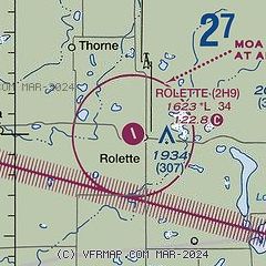
| FAA Identifier: | 2H9 |
| Lat/Long: | 48-40-00.7050N 099-51-11.3800W
48-40.011750N 099-51.189667W
48.6668625,-99.8531611
(estimated) |
| Elevation: | 1623 ft. / 495 m (estimated) |
| Variation: | 09E (1985) |
| From city: | 1 mile W of ROLETTE, ND |
| Time zone: | UTC -5 (UTC -6 during Standard Time) |
| Zip code: | 58366 |
Airport Operations
| Airport use: | Open to the public |
| Activation date: | 10/1949 |
| Control tower: | no |
| ARTCC: | MINNEAPOLIS CENTER |
| FSS: | GRAND FORKS FLIGHT SERVICE STATION |
| NOTAMs facility: | GFK (NOTAM-D service available) |
| Attendance: | UNATNDD |
| Wind indicator: | lighted |
| Segmented circle: | no |
| Lights: | ACTVT LIRL RY 15/33 - CTAF. |
Airport Communications
| CTAF/UNICOM: | 122.8 |
| WX AWOS-3 at 06D (16 nm NE): | 118.125 (701-477-0055) |
| WX AWOS-3 at RUG (18 nm S): | 118.475 (701-776-6100) |
Airport Services
| Parking: | tiedowns |
| Airframe service: | NONE |
| Powerplant service: | NONE |
| Bottled oxygen: | NONE |
| Bulk oxygen: | NONE |
Runway Information
Runway 15/33
| Dimensions: | 3400 x 40 ft. / 1036 x 12 m |
| Surface: | asphalt, in good condition |
| Weight bearing capacity: | |
| Runway edge lights: | non-standard
LIRL NSTD SPACE 20 FT FROM RY EDGE & 2 FT HIGHER THAN RY ELEV. |
| RUNWAY 15 | | RUNWAY 33 |
| Latitude: | 48-40.273333N | | 48-39.750167N |
| Longitude: | 099-51.338333W | | 099-51.041000W |
| Elevation: | 1623.0 ft. | | 1622.0 ft. |
| Traffic pattern: | left | | left |
| Runway heading: | 150 magnetic, 159 true | | 330 magnetic, 339 true |
| Markings: | basic, in good condition | | basic, in good condition |
| Touchdown point: | yes, no lights | | yes, no lights |
| Obstructions: | 60 ft. trees, 1600 ft. from runway, 200 ft. right of centerline, 23:1 slope to clear | | 19 ft. road, 440 ft. from runway, 150 ft. left of centerline, 12:1 slope to clear |
Airport Ownership and Management from official FAA records
| Ownership: | Publicly-owned |
| Owner: | ROLETTE AIRPORT AUTHORITY
BOX 367
ROLETTE, ND 58366
Phone 701-201-0504 |
| Manager: | RICHARD ARSTEIN
BOX 367
ROLETTE, ND 58366
Phone 701-201-0504
ADDNL PHONE FOR MGR, 701-228-4083 OR 701-246-3348. |
Additional Remarks
| - | SNOW REMOVAL IREG; CONFIRM WINTER CONDITIONS WITH AMGR - CALL 701-246-3395. |
| - | RY 15 +21 FT ROAD VIOLATES TRANSITIONAL SFC ON W SIDE OF RY PROTECTION ZONE. |
| - | FOR CD CTC MINNEAPOLIS ARTCC AT 651-463-5588. |
Instrument Procedures
There are no published instrument procedures at 2H9.
Some nearby airports with instrument procedures:
06D - Rolla Municipal Airport/Leonard Krech Field (16 nm NE)
KRUG - Rugby Municipal Airport (18 nm S)
D09 - Bottineau Municipal Airport (24 nm NW)
9D7 - Cando Municipal Airport (27 nm SE)
KDVL - Devils Lake Regional Airport (50 nm SE)
|
|

Road maps at:
MapQuest
Bing
Google
| Aerial photo |
|---|
WARNING: Photo may not be current or correct

Do you have a better or more recent aerial photo of Rolette Airport that you would like to share? If so, please send us your photo.
|
| Sectional chart |
|---|
|
| Airport distance calculator |
|---|
|
|
| Sunrise and sunset |
|---|
|
Times for 05-Oct-2025
| | Local
(UTC-5) | | Zulu
(UTC) |
|---|
| Morning civil twilight | | 07:14 | | 12:14 |
| Sunrise | | 07:46 | | 12:46 |
| Sunset | | 19:10 | | 00:10 |
| Evening civil twilight | | 19:41 | | 00:41 |
|
| Current date and time |
|---|
| Zulu (UTC) | 05-Oct-2025 08:15:50 |
|---|
| Local (UTC-5) | 05-Oct-2025 03:15:50 |
|---|
|
| METAR |
|---|
K06D
16nm NE | 050755Z AUTO 02014KT 10SM -DZ FEW038 BKN050 OVC100 11/11 A2967 RMK AO2 LTG DSNT E AND S
|
KRUG
18nm S | 050755Z AUTO 03010KT 2 1/2SM +RA FEW002 BKN019 OVC046 12/12 A2966 RMK AO2 LTG DSNT NE-SE
|
|
| TAF |
|---|
KDVL
50nm SE | 050520Z 0506/0606 03015KT P6SM -RA OVC015 FM050800 02025G32KT 3SM RA BR OVC009 FM051200 35026G38KT 2SM BR VCSH OVC012 FM051900 33017G28KT P6SM BKN045 FM060000 33015KT P6SM SCT045
|
|
| NOTAMs |
|---|
NOTAMs are issued by the DoD/FAA and will open in a separate window not controlled by AirNav.
|
|

